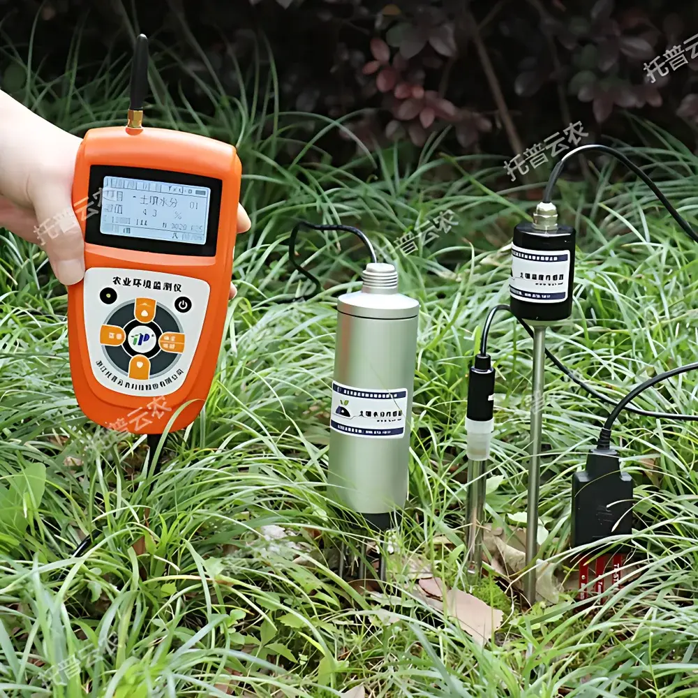
Top Cloud-agri TZS-pHW-4G Multi-parameter Soil Analyzer
| Brand | Top Cloud-agri |
|---|---|
| Origin | Zhejiang, China |
| Manufacturer Type | Manufacturer |
| Product Category | Domestic |
| Model | TZS-pHW-4G |
| Instrument Type | Soil Moisture / Water Potential Analyzer |
| Measurement Parameters | Soil Temperature, Soil Moisture (v/v %), Soil Electrical Conductivity (EC), Soil pH |
| Communication | GPRS + USB + Bluetooth (via App) |
| Data Storage | 30,000 internal Flash entries + expandable 4GB microSD |
| Power | 7.4V 2.8Ah rechargeable Li-ion battery (with low-voltage warning & charging protection) |
| GPS | Integrated high-sensitivity module (WGS84 coordinates, ±5 m CEP) |
| Sensor Interface | IP67-rated multi-channel hub supporting up to 32 sensors |
| Operating Temperature | -20°C to 60°C |
| Display | Backlit Chinese LCD with real-time timestamp, parameter values, storage status, and GPS coordinates |
Overview
The Top Cloud-agri TZS-pHW-4G Multi-parameter Soil Analyzer is an integrated field-deployable instrument engineered for simultaneous, in-situ measurement of four critical soil physical and chemical parameters: soil temperature, volumetric water content (θ, m³/m³), electrical conductivity (EC, mS/cm), and pH. Designed for long-term unattended operation in agricultural research, precision irrigation management, ecological monitoring, and environmental impact assessment, the device employs calibrated solid-state sensor modules adhering to ASTM D511 (pH), ASTM D4972 (EC), and ISO 11276 (soil moisture) methodological principles. Its modular architecture enables direct burial of EC and moisture sensors without encapsulation, while the pH probe utilizes a robust gel-filled reference system optimized for heterogeneous field soils. The analyzer operates on a deterministic sampling protocol—supporting both scheduled interval acquisition (1 min to 24 h) and on-demand manual triggering—ensuring temporal fidelity for diurnal or event-driven soil process studies.
Key Features
- Integrated GPRS telemetry enabling encrypted data transmission to cloud infrastructure at user-defined intervals or on-demand push; supports TLS 1.2 secure handshake with server authentication.
- Dual-platform mobile application (iOS v12+ and Android 8.0+) providing real-time visualization of all four parameters, GPS-tagged location history, and configurable alarm thresholds with audible voice alerts (English/Chinese selectable).
- Low-power embedded ARM Cortex-M4 controller with watchdog timer, brown-out detection, and automatic sleep/wake cycling—achieving >12 months operational life on single battery charge under typical 15-min sampling.
- High-contrast monochrome LCD with localized Chinese interface displaying live sensor outputs, UTC timestamp, SD card status, battery voltage, and WGS84 coordinates (latitude/longitude/altitude).
- Expandable sensor architecture via IP67-rated junction box accepting up to 32 analog (0–2.5 V) or digital (RS485 Modbus RTU) inputs; channel isolation ensures cross-talk < 0.05% FS between simultaneously active probes.
- Built-in GPS receiver compliant with GPS L1 C/A signal standard (1.57542 GHz), delivering position updates every 5 seconds with horizontal accuracy ≤5 m (95% CEP) under open-sky conditions.
- Field-configurable audio feedback: voice-enabled status reporting (e.g., “Moisture below threshold”) with adjustable volume and language selection; alarm activation triggers immediate verbal notification of exceeded parameter limits.
Sample Compatibility & Compliance
The TZS-pHW-4G is validated for use across mineral soils (sand to clay loam), organic substrates (peat, compost), and managed agroecosystems including orchards, vineyards, and greenhouse production systems. All sensor modules meet IP68 ingress protection for continuous submersion (up to 1 m depth for 72 h). Soil moisture sensing follows time-domain transmissometry (TDT) principles per ISO/IEC 17025-accredited calibration protocols traceable to NIM (National Institute of Metrology, China). EC measurements conform to two-electrode conductometric methodology aligned with ISO 11265 for saline soil characterization. pH electrode response is verified against NIST-traceable buffer standards (pH 4.01, 7.00, 10.01). Device firmware and cloud platform comply with GLP data integrity requirements—including electronic audit trails, user role-based access control (RBAC), and immutable timestamped records—supporting regulatory submissions under USDA-NRCS, FAO-SSPS, and national soil health monitoring frameworks.
Software & Data Management
The proprietary Top Cloud-agri Instrument Management Platform operates on a hybrid C/S architecture with redundant AWS-hosted cloud storage (S3 + RDS PostgreSQL backend). Web portal (HTTPS-only) and mobile app provide synchronized access to time-series datasets annotated with geotags, sensor metadata (serial numbers, calibration dates), and environmental context. Data visualization includes interactive dual-Y axis plots, statistical summaries (mean, SD, CV%), and automated anomaly detection using Tukey’s fences (IQR method). Export formats include CSV, Excel (.xlsx), PDF reports (with customizable templates), and NetCDF4 for interoperability with GIS and modeling tools (e.g., SWAT, HYDRUS-1D). Platform supports FDA 21 CFR Part 11-compliant electronic signatures, revision-controlled firmware updates over-the-air (OTA), and granular permission settings for multi-user collaborative projects.
Applications
- Precision irrigation scheduling through real-time θ–EC–pH correlation mapping to optimize water-nutrient delivery and prevent leaching.
- Soil salinity monitoring in coastal or arid-zone agriculture to assess sodicity risk and guide gypsum amendment strategies.
- Long-term soil health assessment in LUCAS (Land Use/Cover Area frame Survey) and national soil monitoring networks.
- Validation of pedotransfer functions (PTFs) and hydrological model boundary conditions using co-located multi-parameter time series.
- Regulatory compliance reporting for landfill cover systems, remediation sites, and constructed wetlands under EPA SW-846 and ISO 10381-6 protocols.
- Academic field experiments requiring synchronized, GPS-referenced soil property dynamics across spatial gradients (e.g., toposequences, tillage transects).
FAQ
What is the maximum cable length supported for remote soil moisture sensors?
Standard configuration includes 1.5 m shielded cables; custom lengths up to 1000 m are available with impedance-matched twisted-pair wiring and optional signal repeaters.
Does the device support external power input during extended deployments?
Yes—8.4 V DC input (≥1000 mA) enables continuous operation while maintaining battery float charge; reverse polarity and overvoltage protection circuits are integrated.
How frequently is factory calibration performed, and what documentation is provided?
Each sensor module ships with NIST-traceable calibration certificates valid for 12 months; recalibration services follow ISO/IEC 17025 procedures with full uncertainty budgets.
Can historical data be migrated from legacy Top Cloud-agri devices to the current cloud platform?
Yes—the platform accepts legacy CSV exports with standardized header fields (timestamp, sensor ID, value, unit) and auto-maps them into unified time-series databases.
Is offline data logging possible if GPRS connectivity is unavailable?
Absolutely—all measurements are redundantly stored in internal Flash (30,000 records) and microSD card (4 GB default); data syncs automatically upon network restoration.
Related Products


