Top Cloud-agri TZS-pHWY-7G Multi-Parameter Soil Analyzer for Moisture, Temperature, EC, pH, Nitrogen, Phosphorus & Potassium
| Brand | Top Cloud-agri |
|---|---|
| Origin | Zhejiang, China |
| Manufacturer Type | OEM/ODM Producer |
| Country of Origin | China |
| Model | TZS-pHWY-7G |
| Instrument Category | Fertilizer & Nutrient Analyzer |
| Communication | 5G/4G Cellular |
| Onboard Storage | 30,000 records (Flash) + 4 GB microSD |
| Power | 7.4 V / 2.8 Ah Li-ion battery (with charging protection & low-voltage alert) |
| GPS | Integrated high-sensitivity module |
| Sensor Expansion | Up to 32 channels via IP67-rated daisy-chain interface |
| Data Upload | Automatic via cellular network or USB bulk transfer |
| Operating Temperature | –40 °C to +85 °C |
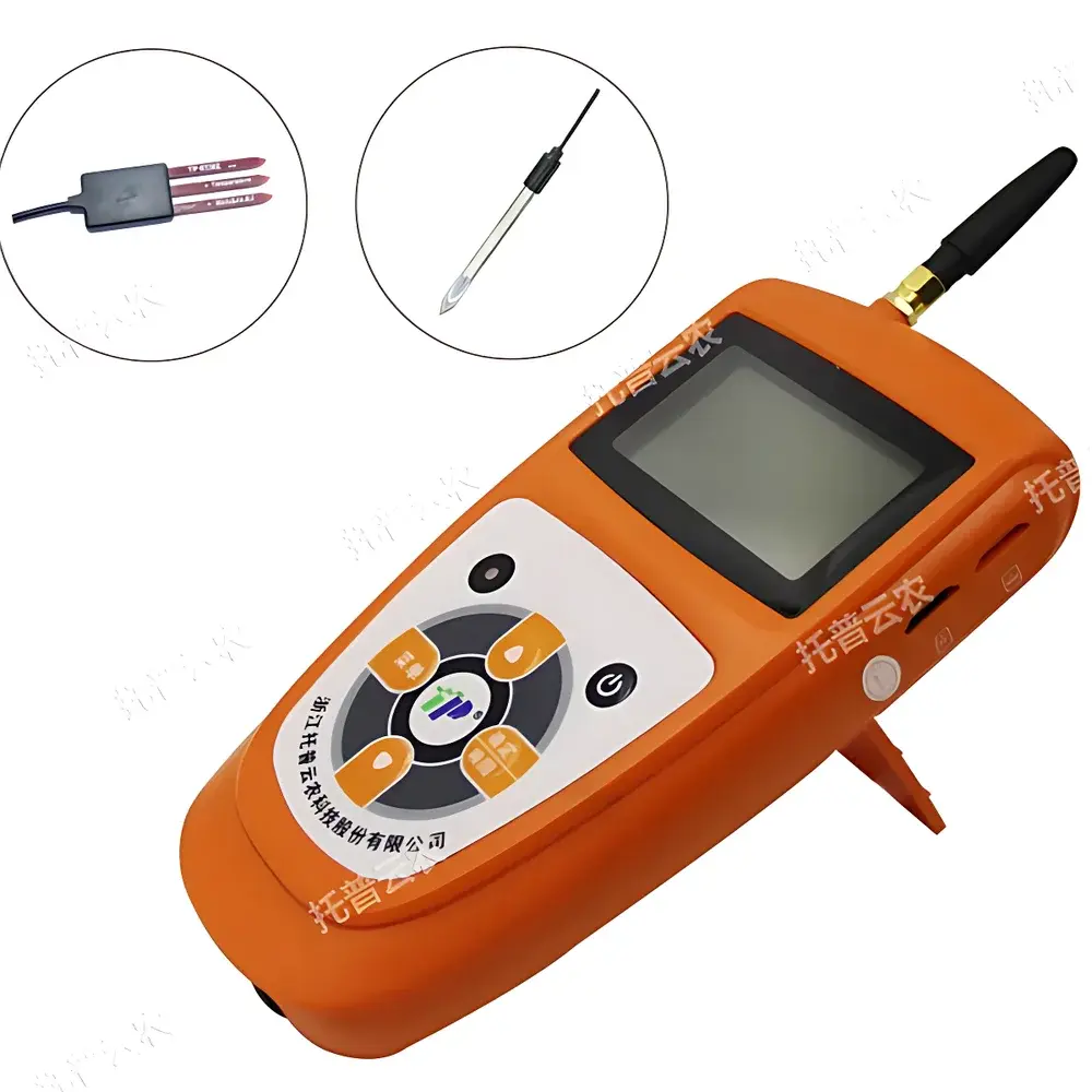
| Display | Backlit Chinese LCD with real-time timestamp, sensor values, storage status, and configuration menu |
Overview
The Top Cloud-agri TZS-pHWY-7G Multi-Parameter Soil Analyzer is a field-deployable, autonomous environmental monitoring instrument engineered for continuous, unattended measurement of seven critical soil physicochemical parameters: volumetric water content (VWC), temperature, electrical conductivity (EC), pH, total nitrogen (N), available phosphorus (P), and exchangeable potassium (K). Unlike single-parameter handheld meters, this integrated analyzer employs calibrated electrochemical (pH, EC), capacitance-based (moisture), thermistor (temperature), and solid-state ion-selective sensor arrays—each validated against standard reference methods per ISO 11277 (soil sampling), ISO 10390 (pH in soil suspensions), and ISO 11265 (electrical conductivity). Designed for long-term deployment in agricultural research stations, precision farming networks, ecological monitoring plots, and land rehabilitation projects, the device operates independently of mains power and supports remote data retrieval via dual-path telemetry—ensuring temporal continuity and spatial traceability across heterogeneous terrain.
Key Features
- Simultaneous real-time acquisition of moisture (0–100% VWC, ±3% accuracy in 0–50% range), temperature (–40 °C to +85 °C, ±0.5 °C), EC (0–23 mS/cm, <2% FS), pH (0–14, 0.1 resolution), N/P/K (0–1999 mg/kg each, ±2% FS)
- Integrated GPS module providing WGS84 coordinates at time of each sample capture—enabling georeferenced time-series mapping and GIS integration
- Dual-storage architecture: 30,000 records retained in onboard Flash memory + expandable 4 GB microSD card (FAT32 formatted); both buffers support synchronized logging
- Low-power embedded architecture with configurable sampling intervals (5 minutes to 99 hours); average standby current draw ≤3 mA
- IP67-rated modular expansion interface supporting up to 32 heterogeneous sensors—including optional nitrate, ammonium, organic matter, or redox potential probes—without cross-channel interference
- Voice-enabled operational feedback: programmable Chinese Mandarin audio alerts for parameter exceedance events; toggleable via on-device menu or cloud command
- Built-in rechargeable 7.4 V / 2.8 Ah lithium-ion battery with overcharge/discharge protection, state-of-charge indicator, and automatic low-voltage warning (≤6.0 V)
Sample Compatibility & Compliance
The TZS-pHWY-7G is optimized for direct insertion into mineral soils (sandy loam to clay loam textures) and amended substrates (e.g., compost-amended fields, greenhouse media). Sensor probe geometry conforms to ASTM D5118-17 guidelines for in-situ soil sensor placement depth (typically 10–20 cm). All electrochemical modules undergo factory calibration traceable to NIST-certified buffer solutions (pH 4.01, 7.00, 10.01) and KCl standards (1.413 mS/cm, 12.88 mS/cm). Data integrity meets GLP-aligned requirements: timestamps are synchronized to UTC via NTP over cellular connection; each record includes sensor ID, calibration epoch, GPS metadata, and CRC-16 checksum. While not FDA 21 CFR Part 11 certified out-of-box, audit-ready export formats (CSV, JSON-LD) support validation protocols required under ISO/IEC 17025-accredited laboratories.
Software & Data Management
The proprietary Top Cloud-agri Instrument Management Platform is a secure, role-based SaaS application accessible via web browser (Chrome/Firefox/Edge) or native iOS/Android clients. It implements C/S architecture with TLS 1.3 encryption, OAuth2 authentication, and granular permission tiers (admin, technician, viewer). Raw sensor streams are ingested in near real-time and stored in time-partitioned PostgreSQL tables with automated daily backups. Visualization tools include interactive multi-axis time-series graphs, heatmaps overlaid on OpenStreetMap tiles, and customizable dashboards with threshold-triggered email/SMS notifications. Export options include PDF reports (with institutional letterhead support), Excel-compatible XLSX, and machine-readable CSV/JSON. All platform updates are delivered over-the-air without service interruption; version history and change logs are retained for ≥12 months.
Applications
- Irrigation scheduling optimization through dynamic soil water potential modeling using concurrent moisture–temperature–EC profiles
- Nutrient use efficiency (NUE) assessment in variable-rate fertilizer trials across maize, wheat, and rice cropping systems
- Salinity intrusion monitoring in coastal aquifer recharge zones and reclaimed tidal flats
- Long-term soil health indexing under conservation tillage, cover cropping, or biochar amendment studies
- Regulatory compliance reporting for national soil quality monitoring programs (e.g., China’s National Soil Pollution Survey Framework)
- Calibration reference for proximal sensing platforms (e.g., drone-mounted multispectral or ground-penetrating radar systems)
FAQ
Does the TZS-pHWY-7G require annual recalibration?
Field recalibration is recommended every 6–12 months depending on usage intensity and soil aggressiveness (e.g., high-salinity or acidic conditions). Factory calibration certificates include uncertainty budgets per parameter.
Can sensor data be exported in formats compatible with statistical analysis software?
Yes—CSV and JSON exports include ISO 8601 timestamps, WGS84 coordinates, sensor metadata, and raw/processed values; all fields are tab-delimited and UTF-8 encoded.
Is the GPS module functional indoors or under dense canopy?
GPS signal acquisition requires open-sky visibility; for forested or greenhouse deployments, coordinate tagging may be supplemented via manual geotagging or external GNSS receivers via Bluetooth serial emulation.
What is the expected service life of the pH and EC electrodes under routine field use?
With proper cleaning (deionized water rinse post-measurement) and storage in KCl solution, electrochemical sensors maintain specification performance for ≥18 months; replacement kits are available as consumables.
How does the system handle data gaps during temporary cellular outages?
All measurements are buffered locally until connectivity resumes; no data loss occurs unless storage capacity is exceeded—buffer fullness alerts are transmitted via SMS when >90% utilized.