TPDM-G-1 Portable Crop Height Measurement System by Top Cloud-agri
| Brand | Top Cloud-agri |
|---|---|
| Origin | Zhejiang, China |
| Manufacturer Type | Direct Manufacturer |
| Country of Origin | China |
| Model | TPDM-G-1 |
| Pricing | Available Upon Request |
| Measuring Rod Height | 1500 mm |
| Measurement Range | 0–1500 mm |
| Accuracy | ±10 mm |
| Housing Material | Aluminum Alloy |
| Operating System | Android |
| Standard Configuration | 1 Android smartphone (pre-installed app), 1 calibrated measuring rod |
| Connectivity | Wi-Fi & 4G-enabled automatic cloud synchronization |
Overview
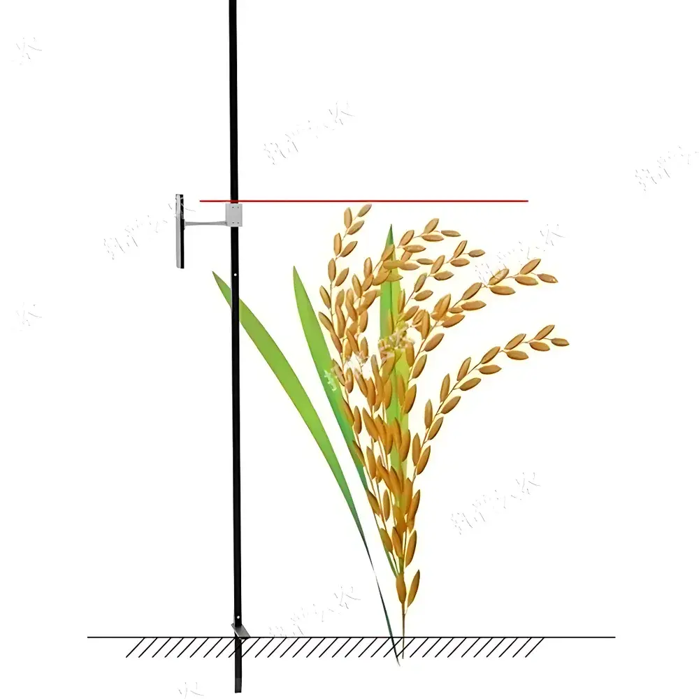
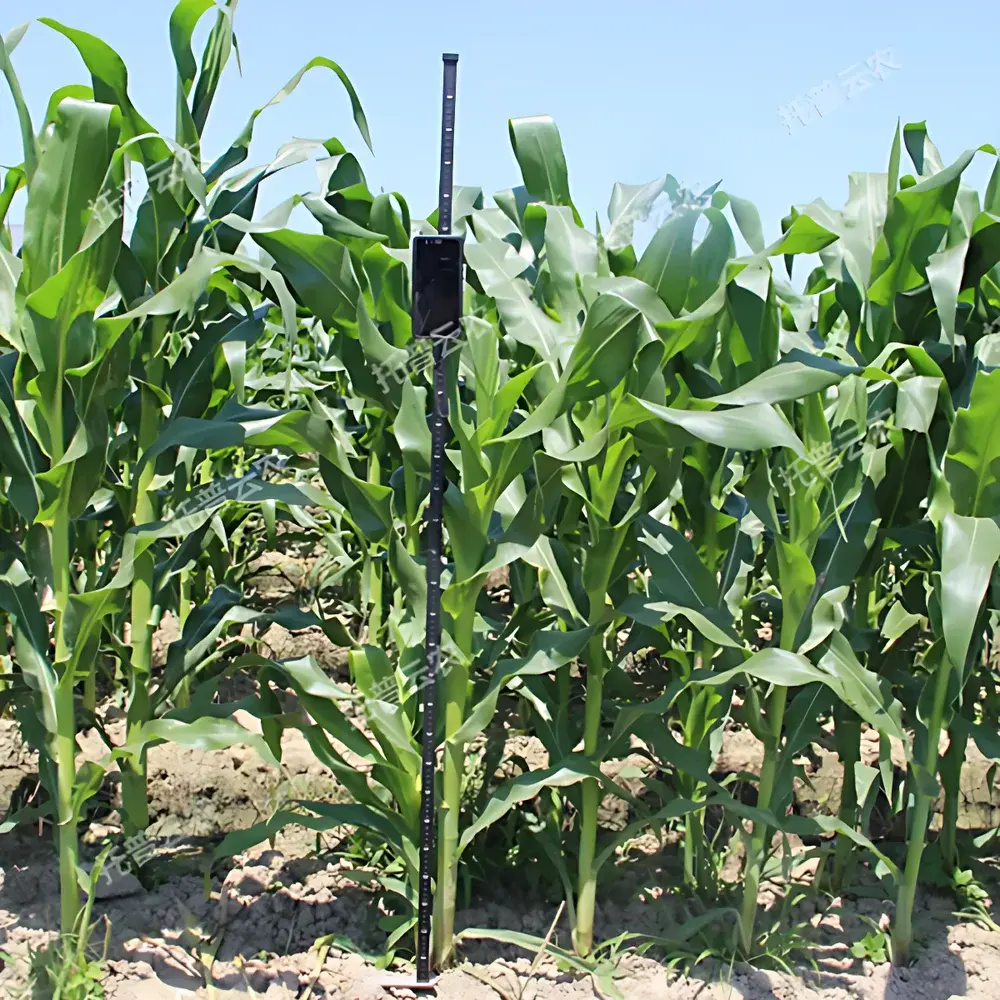
The TPDM-G-1 Portable Crop Height Measurement System is an engineered field-deployable solution designed for rapid, non-destructive quantification of plant height in agronomic and phenotypic research. It operates on a vision-based optical recognition principle: a calibrated aluminum alloy measuring rod—marked with high-contrast metric graduations—is positioned vertically adjacent to the plant stem; an Android smartphone captures a still image aligned with the rod’s scale, and proprietary computer vision algorithms process the image in real time to extract pixel-to-millimeter mapping and compute absolute height values. This approach eliminates manual tape-measure interpolation and operator-dependent parallax errors, delivering consistent, traceable measurements across diverse crop species—including maize (ear height and total height), rice, wheat, soybean, oilseed rape, sorghum, cotton, and fruit trees—within the validated range of 0–1500 mm. The system is purpose-built for high-throughput field trials, breeding nurseries, and longitudinal growth monitoring under variable environmental conditions.
Key Features
- Real-time optical height extraction via smartphone camera and embedded Android application—no external sensors or calibration routines required between uses.
- Integrated metadata capture: users manually input cultivar name, growth stage (e.g., BBCH scale), plot ID, observer ID, and experimental block designation alongside each measurement.
- Automated data synchronization: when Wi-Fi or 4G connectivity is active, measurements—including timestamped images, numerical height values, and contextual metadata—are encrypted and uploaded to the Top Cloud-agri Instrument Cloud Platform.
- Robust mechanical design: lightweight (≤1.2 kg), corrosion-resistant anodized aluminum measuring rod with laser-etched, UV-stable scale markings; optimized for outdoor use in full sunlight and humid field environments.
- Offline-first operation: all measurements are stored locally on the device until network connectivity resumes—ensuring zero data loss during transient signal outages.
- Firmware and application updates delivered over-the-air (OTA) through the cloud platform, maintaining compliance with evolving Android OS versions and security patch requirements.
Sample Compatibility & Compliance
The TPDM-G-1 supports morphological measurement of erect or semi-erect monocot and dicot crops with clearly defined basal nodes and vertical apical dominance. Validation studies confirm reliable performance on maize (Zea mays L.), rice (Oryza sativa L.), winter wheat (Triticum aestivum L.), soybean (Glycine max L.), and Brassica napus L., provided plant canopy density permits unobstructed side-view imaging of the stem base and apex relative to the rod. While not certified to ISO/IEC 17025 for metrological traceability, the system adheres to GLP-aligned data integrity principles: each record contains immutable audit trail fields (creation timestamp, modification timestamp, uploader ID, GPS coordinates if enabled), and all image files are archived losslessly in JPEG2000 format with EXIF metadata preserved. Data export formats comply with FAIR principles (Findable, Accessible, Interoperable, Reusable) and support ingestion into third-party statistical platforms (R, Python pandas, SAS) via CSV and Excel (.xlsx) outputs.
Software & Data Management
The Top Cloud-agri Instrument Cloud Platform functions as a centralized C/S architecture repository supporting multi-device aggregation—including TPDM-G-1 units, soil moisture loggers, canopy spectrometers, and automated weather stations. Web and Android interfaces provide synchronized access to time-series visualization tools: interactive line charts display height progression per plot or genotype, with dynamic zoom, smoothing filters, and statistical overlays (mean ± SD, confidence intervals). All datasets retain full provenance: raw images, processed height values, operator annotations, and geolocation stamps are version-controlled and immutably stored for ≥10 years. Platform-level exports include batch-downloaded Excel workbooks with embedded validation flags (e.g., “low-confidence detection” alerts triggered by motion blur or occlusion), and structured XML reports compatible with LIS/LIMS integration. The platform satisfies FDA 21 CFR Part 11 requirements for electronic records and signatures through role-based access control, audit logs, and digital certificate authentication.
Applications
- Phenotyping pipelines in public and private crop breeding programs for selection of dwarfing or lodging-resistance traits.
- Long-term field experiments assessing genotype × environment (G×E) interactions on vegetative growth dynamics.
- Validation of UAV-based canopy height models using ground-truth reference measurements.
- Teaching laboratories in plant science curricula—demonstrating quantitative trait analysis and digital phenotyping workflows.
- Regulatory field trials requiring auditable, timestamped morphometric documentation per OECD GLP guidelines.
FAQ
What is the minimum measurable height and how is the zero reference established?
The system detects height from the soil surface upward; users place the rod’s base flush with ground level at the plant’s stem base. Minimum measurable height is 0 mm (ground contact point), with reliable detection beginning at ≥50 mm due to algorithmic edge-detection thresholds.
Can the system measure plants taller than 1500 mm?
No—the physical rod length is fixed at 1500 mm and the optical algorithm is calibrated exclusively for this range. For taller crops (e.g., mature maize >2.5 m), users must apply segmented measurement protocols documented in the user manual, with post-hoc summation in the cloud platform.
Is GPS tagging mandatory for data upload?
GPS is optional but strongly recommended. When enabled, it embeds WGS84 coordinates into each record; when disabled, location fields default to “unspecified,” preserving data validity but limiting spatial analytics capabilities.
How frequently does the cloud platform back up data?
Automated daily incremental backups occur at 02:00 UTC, retained for 90 days; full weekly snapshots are archived in geo-redundant object storage compliant with ISO/IEC 27001.
Does the Android app support tablet devices?
Yes—tested and supported on Android 8.0+ tablets with ≥8 MP rear-facing cameras and autofocus capability; however, smartphone form factor is recommended for ergonomic field handling and battery longevity.