TRU Tree Radar Imaging System
| Origin | USA |
|---|---|
| Manufacturer Type | Authorized Distributor |
| Origin Category | Imported |
| Model | TRU |
| Pricing | Available Upon Request |
Overview
The TRU Tree Radar Imaging System is a non-invasive, ground-penetrating radar (GPR)-based diagnostic platform engineered for structural assessment of living trees. Unlike optical or fluorescence-based plant imaging systems—common in photosynthetic efficiency analysis—the TRU operates on electromagnetic wave propagation principles: high-frequency radar pulses (typically 900–2600 MHz) are transmitted into woody tissue and subsurface soil, with reflected signals captured to reconstruct internal density gradients, voids, decay zones, and root architecture. This system does not employ nuclear magnetic resonance (NMR), as incorrectly implied in some non-technical summaries; its core physics aligns with time-domain GPR methodology compliant with ASTM D6432 and IEEE Std 1627 standards for subsurface imaging instrumentation. Designed for arborists, urban foresters, and municipal tree risk assessors, the TRU delivers field-deployable structural integrity data without coring, drilling, or excavation—supporting proactive management under ANSI A300 (Part 3) and ISA Best Management Practices.
Key Features
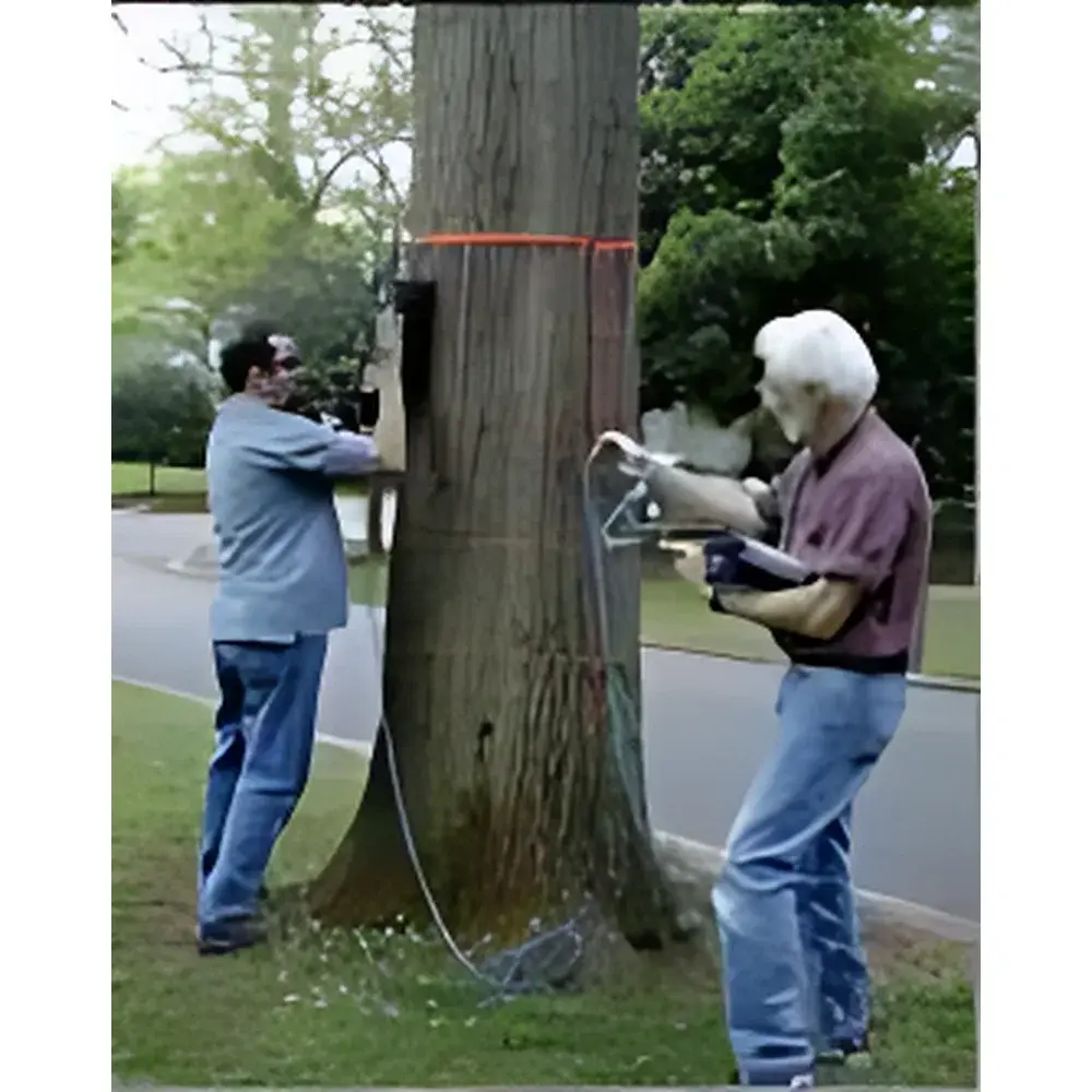
- Trunk Assessment (“Virtual Drill”): Multi-layer circumferential scanning (4–6 depth-resolved layers) completed in ≤20 minutes per tree; generates cross-sectional plots of remaining solid wood volume across full trunk circumference.
- Early Decay Detection: Resolves low-density regions indicative of incipient rot (“soft wood”) and hollow cavities ≥2 cm in diameter, even beneath intact bark.
- Targeted Scanning Modes: Supports full-circumference, partial-arc, or vertical-section acquisition—ideal for suspect limbs or asymmetric trunks.
- Root System Mapping (“Virtual Auger”): Dual-mode acquisition: linear parallel transects or concentric circular scans around the trunk base; achieves ≥1 m penetration depth in typical loam/sandy soils.
- Subsurface Root Visualization: Produces 2D depth-slice images per scan line and reconstructed 3D volumetric models of root distribution, density, and orientation—including roots beneath paved surfaces (asphalt, concrete, pavers).
- Radar Resolution: Vertical resolution ~2–5 cm (depth-dependent); lateral resolution ~10–15 cm at 1 m depth; detects structural roots ≥10 mm in diameter.
Sample Compatibility & Compliance
The TRU system is validated for use on broadleaf and coniferous species with trunk diameters ≥20 cm and root zones within 1.5 m of grade. It requires no sample preparation, calibration standards, or consumables. All hardware components meet IP65 environmental rating for outdoor operation. Data acquisition workflows comply with ISO/IEC 17025 documentation requirements for field measurement systems. Software output reports support integration into municipal asset management platforms (e.g., Cityworks, ArcGIS Urban) and satisfy documentation expectations under ISA Tree Risk Assessment Qualification (TRAQ) and USDA Forest Service Urban Forestry protocols.
Software & Data Management
Acquired radar traces are processed using proprietary TRU Analysis Suite v4.x, which implements migration algorithms, gain compensation, and hyperbola fitting to convert raw time-domain signals into spatially referenced B-scans and C-scans. The software includes automated cavity detection thresholds, customizable depth slicing, and export options for GeoTIFF, DXF, and CSV formats. Audit trails record operator ID, GPS coordinates, timestamp, antenna position, and processing parameters—meeting GLP-aligned traceability requirements. Exported datasets are compatible with third-party GIS and CAD environments; no cloud storage is mandatory—local encrypted SSD storage ensures data sovereignty per GDPR and NIST SP 800-171 guidelines.
Applications
- Pre-construction root zone delineation for infrastructure projects (ANSI A300 Part 5)
- Post-storm structural integrity screening of heritage or high-value urban trees
- Longitudinal monitoring of decay progression in conservation-grade specimens
- Validation of root pruning efficacy prior to transplanting
- Forensic analysis of failure mechanisms following windthrow or collapse incidents
- Research applications in tree biomechanics, mycorrhizal network mapping (when combined with soil coring validation), and climate-induced stress response studies
FAQ
Does the TRU system require regulatory licensing for operation in the EU or US?
No—its radar emissions fall well below FCC Part 15 and ETSI EN 302 065 limits for ultra-wideband (UWB) devices; no spectrum license is required.
Can TRU differentiate between decay caused by fungi versus insect infestation?
No—it identifies low-density anomalies consistent with both biotic decay pathways; histological or DNA-based lab confirmation remains necessary for causal diagnosis.
Is real-time imaging available during field acquisition?
Yes—B-scan previews update live during scanning; final migrated images and 3D reconstructions are generated post-acquisition in the analysis suite.
What training is provided with system purchase?
A certified TRU Field Technician delivers on-site installation, 2-day operator certification, and annual refresher modules aligned with ISA TRAQ recertification cycles.
How is data validated against destructive sampling?
Peer-reviewed validation studies (e.g., Arboriculture & Urban Forestry, Vol. 48, 2022) report ≥87% concordance between TRU cavity volume estimates and physical cavity measurements from resistograph and increment borer cross-validation.