WIRIS Enterprise Infrared Thermal Imaging Measurement System
| Brand | Workswell |
|---|---|
| Origin | Czech Republic |
| Model | WIRIS Enterprise |
| Thermal Resolution (LWIR) | 640 × 512 (up to 1266 × 1010 via super-resolution) |
| Spectral Range | 7.5–13.5 µm |
| Detector Type | Uncooled VOx microbolometer |
| Temperature Range Options | −25 °C to +150 °C |
| NETD | ≤50 mK (standard), optional ≤30 mK |
| Accuracy | ±2% or ±2 °C |
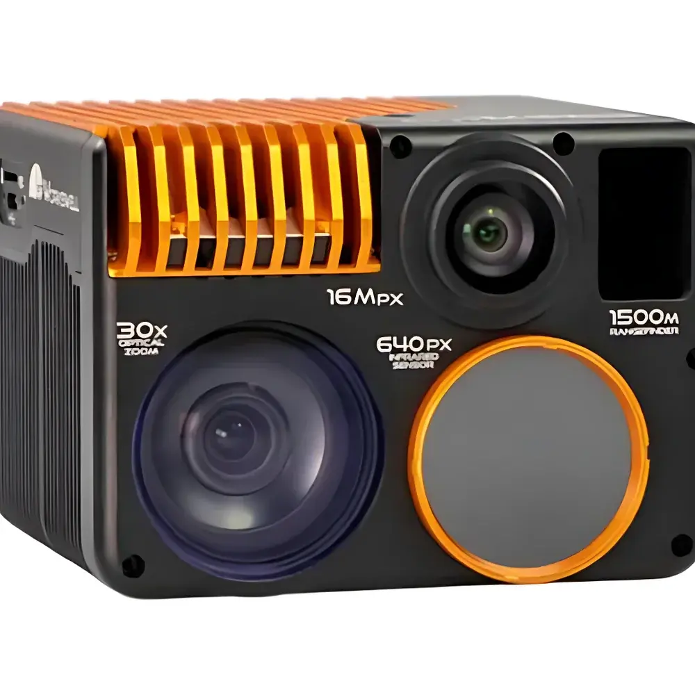
| Visible Light Camera 1 | 16 MP (4656 × 3496), 73.2° FOV |
| Visible Light Camera 2 | Full HD 1080p (1920 × 1080), 30× optical zoom, 1/2.8″ back-illuminated CMOS |
| Laser Rangefinder | 10–1500 m |
| Onboard Storage | 128 GB or 256 GB high-speed SSD |
| Environmental Rating | IP66 |
| Operating Temperature | −15 °C to +50 °C |
| Power Input | 9–36 VDC via 2-pin HARTING connector |
| Dimensions | 76 × 107 × 102 mm |
Overview
The WIRIS Enterprise Infrared Thermal Imaging Measurement System is a multi-sensor, field-deployable imaging platform engineered by Workswell (Czech Republic) for quantitative thermal analysis and synchronized multispectral data acquisition in demanding operational environments. Built upon uncooled vanadium oxide (VOx) microbolometer technology, the system operates in the long-wave infrared (LWIR) spectral band (7.5–13.5 µm), enabling passive, non-contact surface temperature mapping without external illumination. Its core thermal engine delivers native 640 × 512 resolution with hardware-accelerated super-resolution upscaling to 1266 × 1010 pixels—enhancing spatial detail while preserving radiometric integrity. Integrated with dual visible-light sensors—a fixed-focus 16 MP RGB imager and a stabilized 30× optical zoom lens—the system supports simultaneous acquisition of calibrated thermal radiance, high-fidelity photogrammetric imagery, and georeferenced visual context. A Class 1 eye-safe laser rangefinder provides precise distance metadata (10–1500 m), critical for scaling thermal measurements, terrain modeling, and target localization. Designed for integration into both aerial and terrestrial remote sensing architectures, the WIRIS Enterprise serves as a modular payload for UAV platforms—including Ecodrone® series drones—and ground-based PhenoPlot® systems, fulfilling requirements for GLP-aligned field studies, regulatory compliance monitoring, and mission-critical situational awareness.
Key Features
- Multi-sensor fusion architecture: Co-registered LWIR thermal, 16 MP RGB, full-HD 30× optical zoom, and laser distance measurement—all time-synchronized at the hardware level
- High-fidelity thermal imaging: Uncooled VOx detector with ≤50 mK noise-equivalent temperature difference (NETD); selectable calibration ranges from −40 °C to +1500 °C
- Optical stabilization and low-light performance: Back-illuminated 1/2.8″ CMOS sensor with WDR, automatic white balance, IR-cut filter, defogging, and 3D noise reduction
- Onboard radiometric processing: Embedded Linux-based OS supporting real-time spot/area temperature analysis, user-defined alarm thresholds (four modes), and NUC (non-uniformity correction) control
- Ruggedized mechanical design: IP66-rated enclosure rated for continuous operation between −15 °C and +50 °C; compact form factor (76 × 107 × 102 mm) optimized for drone gimbal integration
- Flexible storage and interoperability: Dual-path recording—internal 128 GB / 256 GB NVMe SSD plus microSD/USB expansion—with support for radiometric TIFF (Pix4D, Agisoft Metashape compatible), JPEG, and H.264-encoded video streams
- Standardized power and interface: 9–36 VDC input via ruggedized 2-pin HARTING connector; GPIO and UART interfaces for third-party telemetry synchronization
Sample Compatibility & Compliance
The WIRIS Enterprise is designed for non-destructive, emissivity-aware surface temperature measurement across heterogeneous natural and engineered materials—including vegetation canopies, concrete structures, metallic surfaces, soil substrates, and biological tissues. Its radiometric calibration traceability aligns with ISO 18434-1 (condition monitoring — thermography) and ASTM E1934 (standard guide for examining electrical and mechanical equipment with infrared thermography). The system supports configurable emissivity tables and reflected apparent temperature compensation—enabling accurate quantification under variable environmental conditions. For regulated applications such as industrial safety inspections or environmental impact assessments, its onboard logging includes timestamped metadata (GPS, IMU, laser distance, shutter state) compliant with ISO/IEC 17025 documentation requirements. While not FDA 21 CFR Part 11 certified out-of-the-box, audit-trail functionality (including user login, parameter change logs, and firmware version stamps) can be extended via custom API integration for GxP-aligned deployments.
Software & Data Management
Data acquisition and post-processing are supported through Workswell’s proprietary WIRIS Studio desktop application (Windows/macOS/Linux), which enables batch calibration, emissivity mapping, temporal thermal profiling, and GIS-ready export (GeoTIFF, KML, CSV). All radiometric frames retain full 16-bit dynamic range and embedded calibration coefficients, ensuring reproducibility across analysis workflows. Export formats include radiometric TIFF (with embedded EXIF tags for radiometric parameters), standard JPEG, and H.264 video with synchronized thermal/RGB timestamps. Integration with photogrammetry pipelines is validated for Pix4Dmapper and Agisoft Metashape via standardized EXIF extensions and geotag injection from external GNSS/IMU sources. The system exposes a RESTful API and serial command protocol for OEM-level integration into custom mission control software, autonomous navigation stacks, or SCADA-based infrastructure monitoring systems.
Applications
- Wildlife and conservation ecology: Nocturnal species detection, nest monitoring, thermal signature classification, and habitat use mapping under low-visibility conditions
- Forest fire management: Early smoldering detection, fire front tracking, hotspot prioritization, and post-burn severity assessment using differential emissivity analysis
- Agricultural and forestry health assessment: Canopy temperature differentials for water stress evaluation, disease outbreak screening, and precision irrigation planning
- Industrial predictive maintenance: Electrical substation inspection, mechanical bearing anomaly detection, refractory lining integrity verification, and pipeline leak localization
- Archaeological prospection: Subsurface feature identification via thermal inertia contrast, especially during diurnal transition periods
- Emergency response and civil security: Search-and-rescue operations in smoke-obscured or low-light environments; perimeter surveillance with thermal/visual fusion and laser-assisted targeting
- Geological and environmental monitoring: Volcanic fumarole activity tracking, landfill methane seepage detection, and permafrost degradation assessment
FAQ
Is the WIRIS Enterprise compatible with DJI Matrice 600-series drones?
Yes—the system features standardized mechanical mounting interfaces and power/data pinouts aligned with DJI SDK v4.x and third-party flight controller protocols. Integration requires an optional adapter harness for CAN/UART bridging and gimbal synchronization.
Does the system support real-time streaming over Wi-Fi or Ethernet?
No—WIRIS Enterprise does not include built-in wireless transmission. Video and telemetry output are delivered via Gigabit Ethernet (RJ45) or USB 3.0 for deterministic latency and bandwidth control in mission-critical applications.
Can radiometric data be exported without proprietary software?
Yes—radiometric TIFF files contain embedded calibration metadata readable by open-source tools (e.g., Python’s rasterio, MATLAB Image Processing Toolbox) and comply with the TIFF/EP standard for scientific imaging.
What is the maximum effective frame rate for full-resolution thermal capture?
The native thermal sensor operates at 30 Hz in standard mode; super-resolution mode maintains 25 Hz output with motion-compensated pixel interpolation.
Is firmware update capability available in-field?
Yes—firmware updates are performed via USB or Ethernet using signed binary packages distributed through Workswell’s secure customer portal, with rollback support and checksum validation.