smartcube SmartCIS Camera Image Scanner
| Brand | smartcube |
|---|---|
| Origin | Germany |
| Type | Core Imaging & Surface Digitization System |
| Model | SmartCIS |
| Interface | Ethernet + RS232/USB |
| Software | smartSCAN (with smartDIS database integration) |
| Mounting | Modular, tool-free mechanical assembly |
| Compliance | Designed for geological core logging and digital sample archiving workflows in accordance with ISO 14688-1, ASTM D5079, and GLP-aligned data traceability principles |
Overview
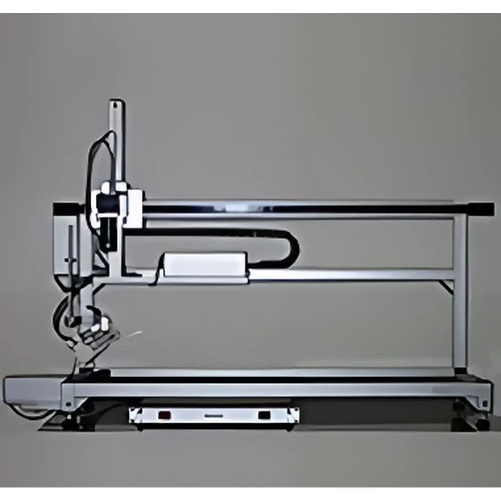
The smartcube SmartCIS Camera Image Scanner is an industrial-grade surface imaging system engineered specifically for high-fidelity digitization of geological core samples—both slabbed (split) and unrolled (whole-round) cores—as well as cuttings, thin sections, rock slabs, and other planar geological specimens. Operating on a precision linear scanning principle, the SmartCIS employs a calibrated digital line-scan camera mounted on a motorized translation stage, capturing continuous, distortion-corrected, pixel-registered image strips along the longitudinal axis of the sample. Each scan produces a georeferenced, orthorectified digital surface map with consistent illumination, uniform resolution (configurable per application), and metadata-enriched EXIF and XML headers. This architecture eliminates parallax error and ensures sub-millimeter spatial repeatability across multi-session acquisitions—critical for long-term core archive integrity and cross-project comparative analysis.
Key Features
- Precision line-scan imaging engine with integrated LED illumination array, optimized for low-glare, shadow-free capture of heterogeneous mineral surfaces.
- Modular mechanical design: tool-free mounting compatible with standard core trays (e.g., 1.5 m or 3.0 m lengths), adjustable for core diameters from 35 mm to 150 mm; optional configurations support slab-only or whole-round operation.
- Plug-and-drive stepper motor system with closed-loop positional feedback—no proprietary interface cards required; connects via standard Ethernet (for camera and controller) and RS232 or USB (for auxiliary sensors or trigger inputs).
- smartSCAN software suite provides real-time preview, automatic seam correction, radiometric calibration (via embedded reference patches), and batch processing with configurable naming conventions and folder structures.
- Fully interoperable with smartcube’s smartDIS Drilling Information System: direct export of TIFF/PNG/JPEG images with embedded core depth metadata, lithological annotations, and borehole context into relational database fields compliant with industry-standard data models (e.g., IADC/OSDU schema extensions).
Sample Compatibility & Compliance
The SmartCIS accommodates a broad spectrum of geological materials—including soft sediments, consolidated sandstones, carbonates, igneous and metamorphic rocks—as well as prepared petrographic thin sections (glass-mounted or resin-embedded) and drill cuttings trays. Its non-contact optical design avoids physical pressure or thermal loading, preserving sample integrity during acquisition. All image metadata conforms to the ISO/IEC 11179 metadata registry framework and includes mandatory fields: borehole ID, core run number, depth interval (top/bottom), scanner calibration timestamp, operator ID, and lighting configuration. Data provenance is preserved through immutable audit trails in smartDIS deployments meeting GLP and internal QA/QC requirements for subsurface data management.
Software & Data Management
smartSCAN operates on Windows-based notebooks or desktop PCs (minimum i5 CPU, 8 GB RAM, SSD storage). It supports dual-mode operation: standalone (local image export only) or network-integrated (real-time ingestion into smartDIS). The software enforces structured metadata entry at acquisition time and permits post-scan annotation using a built-in lithology palette aligned with the IUGS and QAPF classification systems. For regulatory environments, smartSCAN can be configured to generate electronic records compliant with FDA 21 CFR Part 11 when deployed with smartDIS’s validated user access control, electronic signature, and change history modules. Export formats include GeoTIFF (with world files), PNG (8/16-bit), and JPEG2000—each retaining embedded EXIF tags and custom XML sidecar files.
Applications
- Creation and maintenance of virtual core repositories for oil & gas exploration, mining feasibility studies, and academic geoscience research.
- Pre- and post-analysis documentation of core handling events (e.g., sampling, CT scanning, XRF mapping) to support chain-of-custody verification.
- Baseline imaging prior to destructive testing (e.g., plug extraction, thin section preparation) to enable retrospective spatial correlation.
- Integration with machine learning pipelines for automated lithofacies classification, fracture detection, or porosity estimation—using registered image stacks as ground-truth training datasets.
- Support for national geological survey programs requiring FAIR (Findable, Accessible, Interoperable, Reusable) data publishing standards under INSPIRE or GEOSS frameworks.
FAQ
Can SmartCIS scan both whole-round and slabbed cores without hardware reconfiguration?
Yes—mechanical adapters and software-defined scan profiles allow rapid switching between slabbed (flat-face) and whole-round (cylindrical) modes; no recalibration is required between configurations.
Is smartSCAN compatible with third-party GIS or reservoir modeling platforms?
Yes—through OGC-compliant WMS/WFS endpoints exposed by smartDIS, or via direct export of georeferenced rasters with world files and tabular depth metadata in CSV or JSON-LD format.
Does the system support color calibration against standardized targets?
Yes—smartSCAN includes built-in routines for white balance, gamma correction, and spectral response normalization using NIST-traceable ceramic reference tiles placed alongside the core during scanning.
What are the minimum IT infrastructure requirements for networked operation with smartDIS?
A dedicated Gigabit Ethernet segment, Windows Server 2016+, and PostgreSQL 12+ are required for smartDIS backend; smartSCAN clients require only standard TCP/IP connectivity and authenticated API keys.
Can SmartCIS be retrofitted to existing core logging facilities?
Yes—the modular rail system mounts directly onto standard core tray racks; footprint is ≤1.8 m (L) × 0.6 m (W) × 1.2 m (H), with vibration-isolated feet suitable for lab or field-log cabin deployment.
Related Products


 and Vehicle Classification System")
