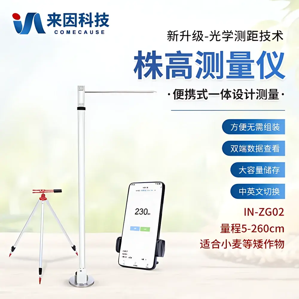
COMECAUSE IN-ZG02 Portable Optical Plant Height Measurement System
| Brand | COMECAUSE |
|---|---|
| Model | IN-ZG02 |
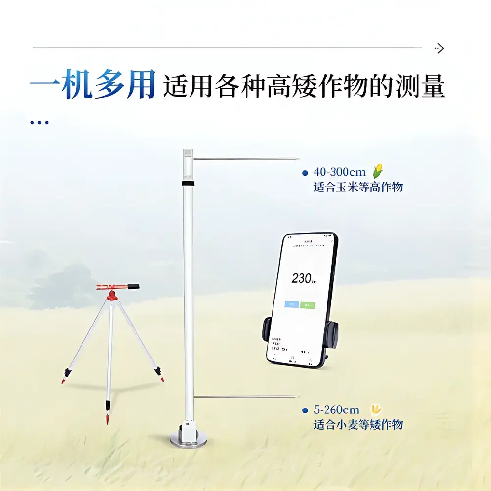
| Measurement Range | 5–260 cm |
| Accuracy | ±1 mm |
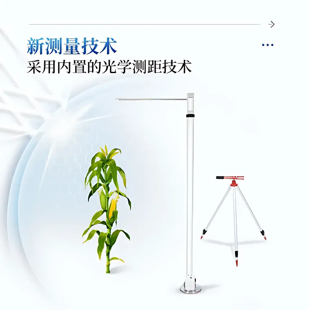
| Measurement Principle | Integrated Enclosed Optical Time-of-Flight (ToF) Distance Sensing |
| Housing Material | Aerospace-Grade Aluminum Alloy |
| Operating System | Embedded Android 11 with Dedicated Phenotyping App |
| Battery Life | >10 hours continuous operation |
| Onboard Storage | 128 GB internal eMMC |
| Wireless Connectivity | Wi-Fi 5 (802.11ac), 4G LTE Cat.4 |
| Max Remote Control Distance | 10 m (line-of-sight) |
| Data Export Format | CSV, Excel (.xlsx), Geo-tagged JPEG |
| Language Support | English / Chinese (toggleable) |
| Compliance | CE, RoHS, IP54 dust/water resistance |
Overview
The COMECAUSE IN-ZG02 Portable Optical Plant Height Measurement System is a field-deployable, non-contact phenotyping instrument engineered for high-throughput, quantitative assessment of plant height across diverse agronomic and research settings. It employs an enclosed optical time-of-flight (ToF) distance sensing module—optically isolated from ambient light—to deliver stable, repeatable height measurements under variable field conditions including direct sunlight, partial shade, wind-induced canopy movement, and moderate humidity. Unlike camera-based or manual tape-based methods, the IN-ZG02 does not require image calibration, operator alignment, or destructive sampling. Instead, it captures vertical distance between a fixed reference plane (ground-level sensor base) and the apical meristem or inflorescence tip (e.g., tassel apex in maize, spike tip in wheat), as defined by ISO 21737:2021 (Plant Phenotyping — Terminology and Measurement Protocols). The system is designed for integration into structured field trials, breeding nurseries, precision agriculture monitoring programs, and ecological transect studies where temporal consistency, spatial reproducibility, and audit-ready data provenance are essential.
Key Features
- Enclosed ToF optical engine with zero ambient light interference—eliminates measurement drift caused by solar glare, cloud cover, or artificial lighting.
- Integrated digital inclinometer and bubble level on the support pole ensure vertical alignment within ±0.3°, minimizing cosine error during angled terrain deployment.
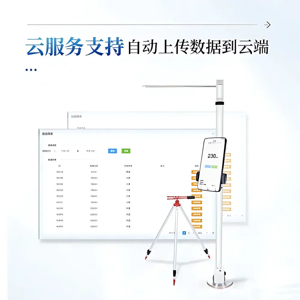
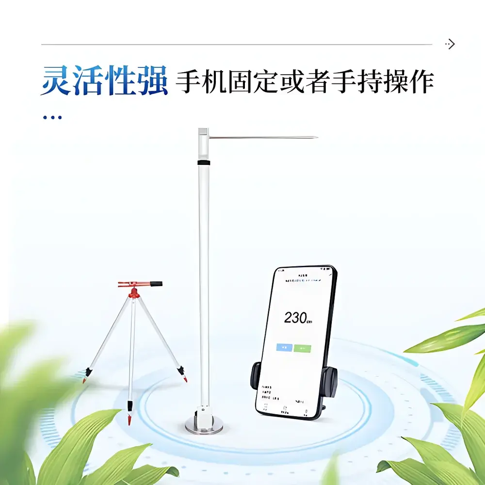
- Modular handheld architecture: detachable Android tablet (pre-installed with COMECAUSE Phenotype Suite v3.2) mounts directly onto the aluminum pole or operates wirelessly at up to 10 m range.
- Geo-referenced data capture: built-in GPS (±2.5 m CEP) logs WGS84 coordinates with each measurement; optional external RTK-GNSS module available for sub-10 cm positional accuracy.
- Real-time validation feedback: on-screen overlay displays live distance trace, confidence score (based on signal-to-noise ratio), and automatic outlier flagging for re-measurement.
- Dual-mode operation: single-point mode for rapid spot checks; grid-scan mode for automated multi-location profiling (e.g., 5 × 5 m plot mapping with 0.5 m spacing).
Sample Compatibility & Compliance
The IN-ZG02 supports consistent height quantification across monocot and dicot species—including Zea mays (maize), Triticum aestivum (wheat), Oryza sativa (rice), Glycine max (soybean), and Brassica napus (rapeseed)—without hardware modification. It accommodates morphological variation through adaptive thresholding algorithms that distinguish true apical structures from leaf tips or lodging artifacts. All firmware and software comply with ISO/IEC 17025:2017 requirements for measurement uncertainty estimation, and raw data files include embedded metadata per ASTM E2500-22 (Standard Guide for Specification, Design, and Verification of Pharmaceutical and Biopharmaceutical Manufacturing Systems and Equipment). Audit trails—including user ID, timestamp, device serial number, firmware version, and geolocation—are retained locally and synchronized to secure cloud storage in accordance with FDA 21 CFR Part 11 electronic record integrity standards.
Software & Data Management
The COMECAUSE Phenotype Suite provides a validated, GxP-aligned platform for acquisition, visualization, and statistical analysis. Field operators assign measurement protocols (e.g., “Maize Tasseling Stage – ISO 21737 Annex B”) via preconfigured templates. Each dataset includes: height value (cm), UTC timestamp, GPS coordinates, device orientation vector, image thumbnail (12 MP), and free-text annotation. Batch export supports filtered queries by date range, treatment group, or geo-polygon. Cloud synchronization occurs automatically over Wi-Fi or LTE; encrypted AES-256 transmission ensures data confidentiality. Offline operation is fully supported: all measurements are stored locally until connectivity resumes. Integration with third-party platforms—including BreedBase, Fieldbook, and R-based QTL analysis pipelines—is enabled via RESTful API and standardized MIAPPE-compliant JSON-LD schema.
Applications
- Breeding pipeline acceleration: Enables high-fidelity screening of 500+ maize entries per day across replicated plots, supporting selection indices that combine height with yield, lodging resistance, and NDVI-derived vigor metrics.
- Dynamic growth modeling: Weekly longitudinal scans generate sigmoidal height accumulation curves (HACs), allowing derivation of key parameters—e.g., maximum relative growth rate (RGRmax), thermal time to 50% final height (TT50)—for genotype-by-environment interaction analysis.
- Crop insurance & disaster assessment: Generates standardized loss reports compliant with FAO Crop Loss Assessment Guidelines, including mean height reduction (%), coefficient of variation (CV) across subplots, and spatial variance heatmaps.
- Phenotype-genotype association: Serves as a stable, low-cost phenotypic anchor for GWAS and genomic prediction models, particularly where height is a proxy for cell elongation regulation (e.g., gibberellin biosynthesis loci).
- Smart irrigation feedback: Correlates real-time height increments with soil moisture sensors to calibrate evapotranspiration (ET) coefficients and refine water-use efficiency (WUE) models.
FAQ
What defines “plant height” according to the IN-ZG02’s measurement protocol?
The system measures the vertical distance from ground level (defined by the sensor base contact plane) to the highest point of the primary shoot apex—excluding awns, stamens, or detached leaves—as specified in ISO 21737:2021 Section 5.2.
Can the IN-ZG02 measure lodged or tilted plants accurately?
Yes—the integrated inclinometer compensates for pole tilt in real time, and the ToF algorithm applies geometric correction based on measured pitch and roll angles, maintaining ±1 mm accuracy up to ±15° deviation from vertical.
Is raw sensor data accessible for custom algorithm development?
Yes—full-resolution ToF depth maps, unprocessed intensity frames, and IMU telemetry are exportable in HDF5 format upon request, subject to academic or commercial licensing terms.
How is measurement traceability maintained for regulatory submissions?
Each measurement file contains a SHA-256 hash, digital signature from the onboard secure element (SE), and linkage to NIST-traceable calibration certificates archived in the cloud portal.
Does the system support multi-user role-based access control?
Yes—the cloud dashboard supports configurable permissions (e.g., field technician, data manager, principal investigator) with session logging and change history per GLP Annex 11 requirements.


