HACH OTT Qliner2 Acoustic Doppler Current Profiler (ADCP) for Traverse Flow Measurement
| Brand | OTT Hydromet |
|---|---|
| Origin | Germany |
| Model | OTT Qliner2 |
| Velocity Range | ±10 m/s |
| Velocity Accuracy | ±1% of reading or ±0.5 cm/s |
| Sampling Rate | up to 1 Hz |
| Beam Frequency | 1 MHz / 2 MHz |
| Depth Range | 20 m (1 MHz) / 10 m (2 MHz) |
| Cell Size | 0.3–4 m (1 MHz) / 0.1–2 m (2 MHz) |
| Minimum Blanking Distance | 0.2 m (1 MHz) / 0.05 m (2 MHz) |
| Max. Number of Cells | 40 |
| Temperature Range | –4 °C to 40 °C |
| Temp. Accuracy/Resolution | ±0.1 °C / 0.01 °C |
| Operating Temp. | –5 °C to 40 °C |
| Storage Temp. | –20 °C to 45 °C |
| Ingress Protection | IP68 |
| Shock Resistance | IEC 721-3-2 |
| Vessel Dimensions | 940 × 470 × 223 mm |
| Weight | 11 kg (including sensor and battery) |
| Power | Rechargeable 12 V DC battery, ~24 h operation |
| Wireless Interface | Bluetooth 2.4 GHz, up to 150 m range |
| PDA OS | Windows Mobile with localized Chinese GUI |
| PC Software | Data visualization, ASCII export, profile replay, and QA/QC post-processing |
Overview
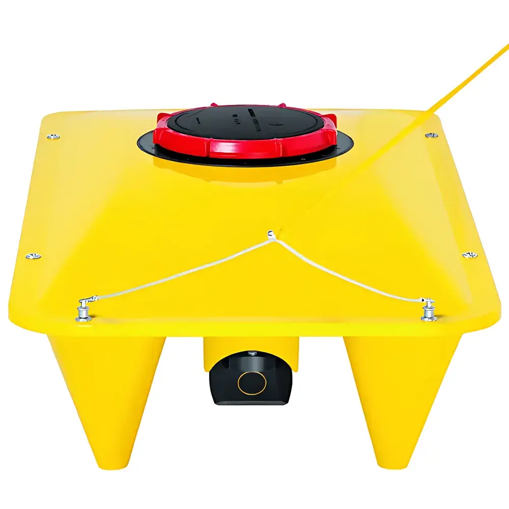
The HACH OTT Qliner2 is a compact, self-contained acoustic Doppler current profiler (ADCP) designed for high-accuracy, traverse-based discharge measurement in natural rivers, artificial channels, and constrained hydraulic sections—including bridge-controlled cross-sections and steep-slope flumes. Unlike fixed-mount ADCPs or mechanical current meters, the Qliner2 employs a four-beam, broadband ultrasonic transducer array mounted on a low-center-of-gravity trisail hull to acquire velocity profiles across the water column while moving laterally along a pre-defined transect. Its operational principle relies on coherent pulse-to-pulse phase difference analysis of backscattered acoustic energy from suspended particles—enabling direct computation of three-dimensional velocity components (u, v, w) within discrete depth cells. The system operates at dual frequencies (1 MHz and 2 MHz), allowing adaptive selection based on depth, turbidity, and required resolution. With no moving mechanical parts, immunity to bedload motion, and independence from GNSS positioning, the Qliner2 delivers repeatable, field-deployable measurements under variable hydrometric conditions.
Key Features
- Four-beam acoustic Doppler architecture: two oblique beams (±25° from vertical) for horizontal velocity profiling, one vertical beam for bathymetric referencing and depth determination, and one shallow-water compensation beam for improved near-bed accuracy.
- True traverse-mode operation: eliminates reliance on GPS or external positioning systems; position inferred via manual rope-guided transit along calibrated transect lines.
- Robust marine-grade fiberglass hull: fully sealed IP68 enclosure, low center of gravity, and absence of protruding sensors ensure stability in choppy or confined waters.
- Integrated rechargeable 12 V DC power system: supports full-day field deployment (~24 h continuous operation) without external power sources.
- Bluetooth 2.4 GHz wireless interface: enables real-time telemetry and remote control up to 150 m line-of-sight distance—allowing operators to remain safely ashore during measurement.
- Onboard flow computation engine: calculates cross-sectional discharge, mean velocity, and cell-wise velocity vectors directly on the PDA, reducing post-processing latency.
Sample Compatibility & Compliance
The Qliner2 is validated for use in open-channel flow environments ranging from 0.2 m to 20 m depth, including gravel-bed rivers, concrete-lined canals, and vegetated floodplains. It complies with ISO 748:2022 (Measurement of liquid flow in open channels — Velocity-area method) and ASTM D5388-20 (Standard Practice for Acoustic Doppler Velocity Measurements). Its measurement uncertainty (<1% of reading or ±0.5 cm/s, whichever is greater) satisfies requirements for regulatory reporting under national hydrometric networks and water resource management frameworks. The system’s hardware design meets IEC 721-3-2 environmental stress standards for outdoor industrial equipment, and its firmware architecture supports audit-trail logging for GLP-compliant data acquisition workflows.
Software & Data Management
Field operations are managed via a Windows Mobile-based PDA application featuring a bilingual (English/Chinese) GUI, intuitive transect planning tools, and real-time profile visualization. The software supports automatic cell averaging, noise filtering, and dynamic blanking zone adjustment. Post-mission data transfer to PC occurs via USB or Bluetooth sync, where the desktop application provides advanced QA/QC functions—including velocity vector reconciliation, outlier detection, ASCII and CSV export, time-series plotting, and cross-section geometry overlay. All raw binary files retain embedded metadata (timestamp, battery voltage, temperature, beam status), ensuring traceability per ISO/IEC 17025 and FDA 21 CFR Part 11 principles when configured with electronic signature support.
Applications
- Discharge monitoring in small- to medium-sized rivers (typically < 100 m wide, < 20 m deep) where traditional current-meter surveys are logistically impractical.
- Routine calibration and validation of permanent stage-discharge rating curves, especially in sites affected by bedform migration or scour/fill cycles.
- Emergency flood response: rapid deployment for real-time flow assessment during high-water events without requiring bridge access or shore-based infrastructure.
- Environmental flow studies: longitudinal velocity profiling for habitat modeling, sediment transport analysis, and thermal plume mapping.
- Verification of computational fluid dynamics (CFD) model boundary conditions and validation of AI-driven flow forecasting systems.
FAQ
Does the Qliner2 require GPS or external positioning hardware?
No. Positioning is achieved manually via rope-guided transit along a marked transect; no GNSS signal is used or required.
Can the Qliner2 operate in very shallow water?
Yes—the 2 MHz configuration achieves a minimum blanking distance of 0.05 m and supports reliable profiling down to 0.2 m total depth.
How is bottom detection performed without contact?
The vertically oriented beam (Beam 4) measures echo return time and amplitude to determine both water depth and bed morphology, enabling accurate cell layering even over mobile or irregular substrates.
Is the system suitable for long-term unattended deployment?
The Qliner2 is optimized for mobile, operator-led surveys—not permanent installation. For continuous monitoring, consider the OTT QL3 or OTT Parsivel²-based telemetry solutions.
What level of training is required for certified operation?
Operators must complete OTT-certified ADCP fundamentals training, including ISO 748 interpretation, transect design, uncertainty budgeting, and software QA/QC procedures—typically delivered as a 2-day field workshop.