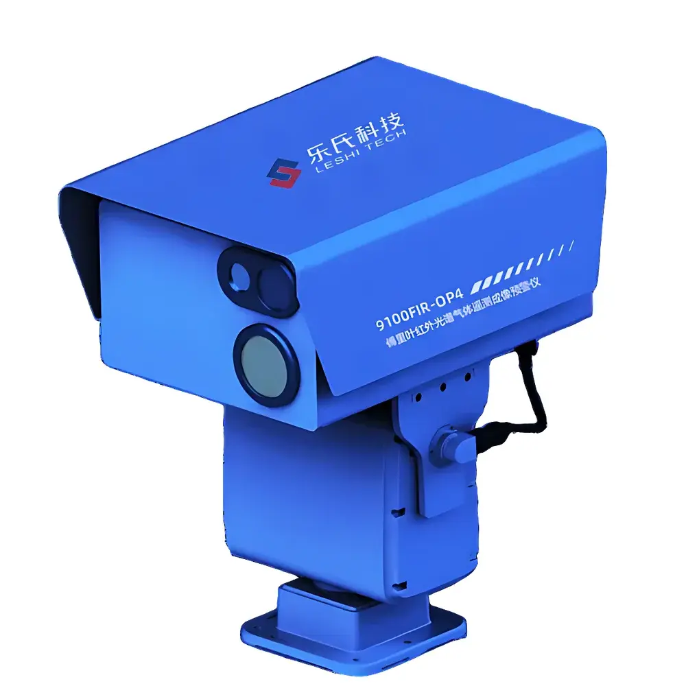
LESHI 9100FIR-OP4 ODS Stereoscopic Leak Monitoring and Early-Warning System
| Brand | LESHI |
|---|---|
| Origin | Beijing, China |
| Manufacturer Type | Authorized Distributor |
| Regional Classification | Domestic (China) |
| Model | 9100FIR-OP4 ODS |
| Price | USD 420,000 (FOB Beijing) |
Overview
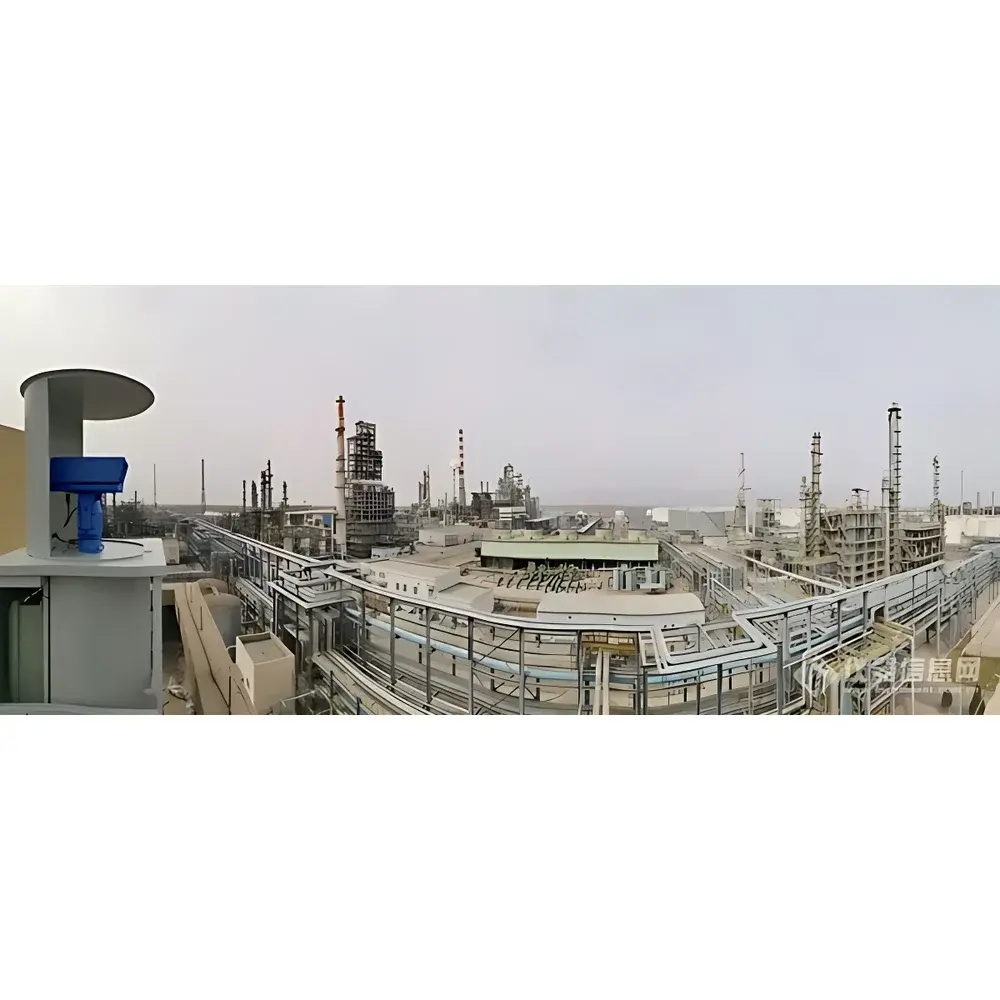
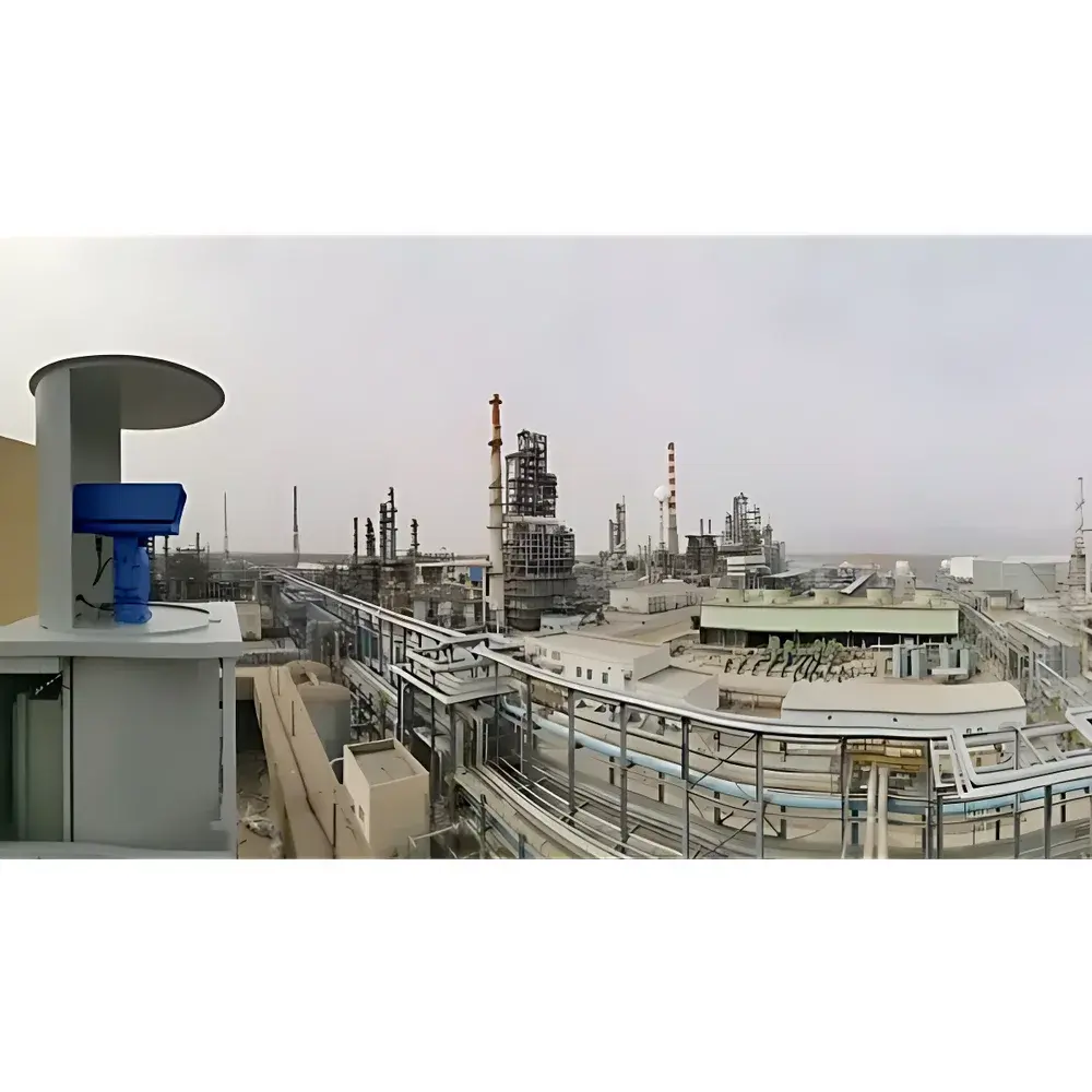
The LESHI 9100FIR-OP4 ODS Stereoscopic Leak Monitoring and Early-Warning System is an integrated remote sensing platform engineered for continuous, non-contact detection and spatially resolved quantification of ozone-depleting substances (ODS) — including CFCs, HCFCs, halons, carbon tetrachloride, methyl chloroform, and methyl bromide — in open-air industrial environments. Based on Fourier-transform infrared (FTIR) hyperspectral imaging coupled with passive standoff optical path analysis, the system operates on the principle of spectral absorption fingerprinting: it captures thermal infrared radiance emitted by ambient background surfaces (e.g., buildings, terrain, or sky), measures minute attenuation across characteristic vibrational-rotational absorption bands (typically 700–1400 cm⁻¹), and reconstructs real-time 2D concentration maps via radiative transfer modeling and spectral unmixing algorithms. Designed for operational deployment in complex terrain and variable meteorological conditions, the system delivers true stereoscopic monitoring — combining angular diversity from multiple viewing geometries, temporal persistence across diurnal cycles, and spatial coherence across kilometer-scale perimeters — enabling robust leak localization, plume trajectory estimation, and mass emission rate approximation without physical sampling.
Key Features
- Passive FTIR hyperspectral imaging with spectral resolution ≤0.5 cm⁻¹ and spectral sampling interval ≤0.25 cm⁻¹, optimized for ODS-specific absorption features
- Standoff detection range up to 5 km radius under typical atmospheric visibility (>10 km), with automatic scanning capability across azimuth (0–360°) and elevation (−15° to +45°)
- Real-time gas identification and semi-quantitative concentration estimation completed within ≤2 seconds post-scan initiation
- Stirling-cooled MCT (mercury cadmium telluride) detector array ensuring stable thermal performance without cryogenic consumables (e.g., liquid nitrogen)
- Multi-modal deployment architecture supporting tripod-mounted portable operation, vehicle-integrated mobile surveillance, and permanent rooftop or tower-based installation
- Integrated georeferencing module (GNSS + IMU) enabling pixel-level geo-tagging of concentration data and dynamic plume vector overlay on GIS basemaps
- Interoperability with contact-based analyzers (e.g., GC-MS, PID, electrochemical sensors) via standardized OPC UA and MQTT interfaces to support hierarchical monitoring workflows (“macro-alert → micro-verification”)
- Onboard edge processing unit running embedded Linux with deterministic real-time scheduling for low-latency spectral analysis and alarm triggering
Sample Compatibility & Compliance
The system is validated for detection of all substances listed in Annex A, B, C, and E of the Montreal Protocol, including but not limited to CFC-11, CFC-12, HCFC-22, Halon-1211, Halon-1301, CCl₄, CH₃CCl₃, and CH₃Br. It complies with ISO 14064-3:2019 requirements for greenhouse gas (GHG) and controlled substance verification instrumentation, and supports audit-ready data logging aligned with GLP principles. Raw interferograms and processed concentration rasters are stored with full metadata (timestamp, GPS coordinates, ambient T/RH/pressure, optical path length, calibration status) in HDF5 format. Optional integration with EPA Method 325B-compliant reporting templates is available for regulatory submittals.
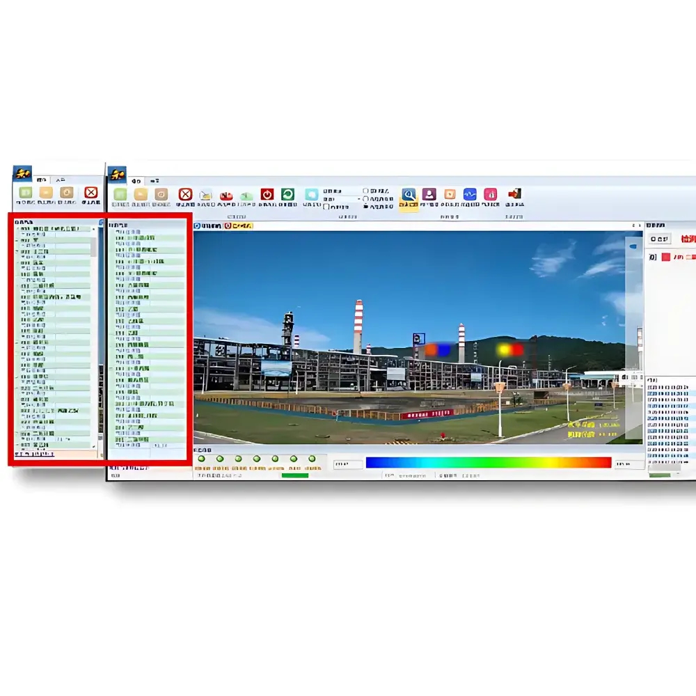
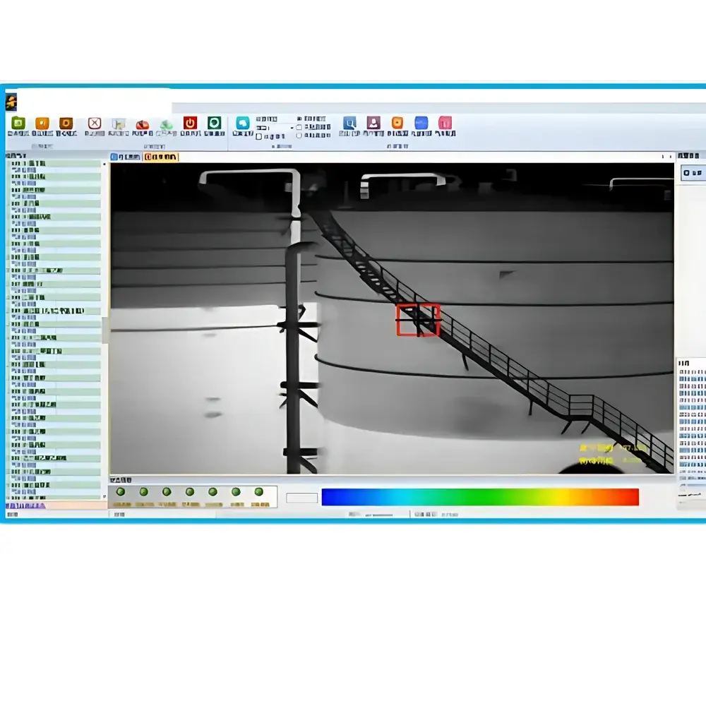
Software & Data Management
The proprietary LESHI ODS-Monitor Suite provides a web-based interface (accessible via secure TLS 1.2+ connection) for configuration, visualization, and alert management. Core modules include: (i) Real-time plume animation engine with wind-field-adapted dispersion modeling (Gaussian puff superposition); (ii) Historical trend dashboard with customizable time-series aggregation (hourly/daily/weekly); (iii) Alarm rule editor supporting multi-threshold logic (concentration, rate-of-change, spatial extent); (iv) Audit trail log recording all user actions, parameter changes, and firmware updates with SHA-256 hashing; (v) Export functionality compliant with ASTM D7923-21 for environmental monitoring data exchange. All data transfers adhere to IEC 62443-3-3 security requirements, and optional 21 CFR Part 11 compliance packages include electronic signature enforcement and role-based access control (RBAC).
Applications
- Continuous perimeter monitoring of chlorofluorocarbon (CFC) and hydrochlorofluorocarbon (HCFC) production facilities to verify containment integrity and detect fugitive emissions
- Regulatory enforcement support for environmental protection bureaus conducting area-wide ODS emission inventories and hotspot attribution studies
- Rapid response assessment during chemical incident scenarios involving suspected ODS release, enabling safe standoff reconnaissance prior to personnel entry
- Long-term trend analysis for corporate sustainability reporting under CDP (Carbon Disclosure Project) and TCFD frameworks
- Integration into smart industrial park infrastructure for automated cross-validation between distributed sensor networks and aerial/satellite remote sensing assets
FAQ
What ODS compounds does the 9100FIR-OP4 detect by default?
The system ships with a pre-validated spectral library covering all 96 ODS substances regulated under the Montreal Protocol Annexes. Custom spectral signatures can be added via offline calibration using NIST-traceable reference cells.
Does the system require external power or internet connectivity at the monitoring site?
The core unit operates on 24 VDC input and includes an integrated UPS with ≥4 h backup runtime. While real-time cloud telemetry is optional, local data storage (≥1 TB SSD) and onboard analytics function fully offline.
How is measurement accuracy verified in field conditions?
Biannual field validation is performed using co-located open-path FTIR reference systems traceable to NIM (National Institute of Metrology, China) standards, with documented uncertainty budgets per ISO/IEC 17025.
Can the system distinguish overlapping plumes from multiple simultaneous leaks?
Yes — through constrained non-negative matrix factorization (cNMF) applied to hyperspectral image cubes, enabling decomposition of spectrally correlated but spatially distinct emission sources.
Is the software compatible with existing enterprise GIS or SCADA platforms?
Yes — RESTful APIs, GeoJSON export, and Modbus TCP gateways are provided for integration with Esri ArcGIS, Siemens Desigo, Honeywell Experion, and similar platforms.


