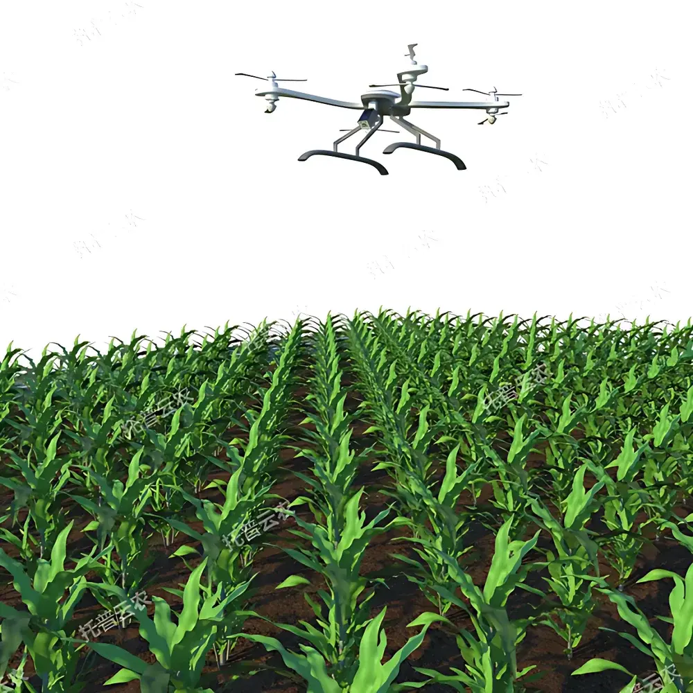
Top Cloud-agri TP-GTL-AIR Field-Deployable UAV-Based High-Throughput Plant Phenotyping Platform
| Brand | Top Cloud-agri |
|---|---|
| Origin | Zhejiang, China |
| Manufacturer Type | OEM Manufacturer |
| Region of Origin | Domestic (China) |
| Model | TP-GTL-AIR |
| Pricing | Available Upon Request |
Overview
The Top Cloud-agri TP-GTL-AIR is a field-deployable, UAV-integrated high-throughput plant phenotyping platform engineered for rigorous, scalable phenotypic assessment under real-world agronomic conditions. Unlike greenhouse-based or stationary imaging systems, the TP-GTL-AIR leverages autonomous aerial mobility to capture spatially resolved, multi-modal spectral data across heterogeneous field plots—enabling quantitative analysis of canopy architecture, biomass accumulation, phenological progression, and physiological status at population scale. Its core measurement principle relies on synchronized passive optical sensing: reflectance spectra acquired across visible (RGB), near-infrared (NIR), short-wave infrared (SWIR), and thermal infrared (TIR) bands are processed using radiometrically calibrated algorithms to derive biophysically meaningful traits—including NDVI, NDRE, PRI, LAI, canopy temperature differentials, and chlorophyll-related indices. Designed for integration into breeding pipelines and precision agriculture workflows, the system operates within the constraints of ISO 11727 (remote sensing data quality assurance) and supports traceable metadata tagging aligned with MIAPPE (Minimum Information About a Plant Phenotyping Experiment) v1.1 standards.
Key Features
- Autonomous flight architecture with pre-programmed mission planning, real-time GNSS/RTK positioning (≤5 cm horizontal accuracy), and obstacle detection via stereo vision + ultrasonic sensors
- Modular sensor payload compatibility: swappable gimbal-mounted modules for RGB (20 MP global shutter), multispectral (5–12 discrete bands, 400–900 nm), hyperspectral (VNIR, 350–1000 nm, 3.5 nm FWHM), and thermal infrared (640 × 512 microbolometer, ±2 °C accuracy)
- Onboard edge computing unit enabling real-time georeferenced orthomosaic generation, pixel-level vegetation index computation, and anomaly detection (e.g., localized water stress or early-stage necrosis)
- Fail-safe operational protocols: low-battery auto-return-to-home (RTH), signal-loss RTH, dual IMU redundancy, and firmware-locked geo-fencing for regulatory compliance
- IP54-rated airframe with extended flight endurance (≥35 min at 8 m/s cruise speed, 1.2 kg max takeoff weight) optimized for daily deployment in variable wind and ambient light conditions
Sample Compatibility & Compliance
The TP-GTL-AIR is validated for use across major cereal, legume, oilseed, and horticultural crops—including but not limited to wheat, maize, rice, soybean, rapeseed, tomato, and lettuce—under open-field, rainfed, and irrigated management systems. It accommodates phenotypic assessment from emergence through senescence, supporting organ-level identification (panicles, tillers, pods, fruits) and developmental stage classification (BBCH scale). All data acquisition workflows comply with FAO’s Crop Ontology standards and support audit-ready metadata export per OECD GLP Annex III requirements. Sensor calibration certificates (traceable to NIST SRM 2036 and 2037) are provided with each delivery, and raw radiance data adheres to HDF5 format specifications for interoperability with CropGrid, BreedBase, and BrAPI-compliant platforms.
Software & Data Management
The platform integrates with Top Cloud-agri’s proprietary PhenotypeCloud™ software suite—a web-based, role-based SaaS application supporting collaborative annotation, trait extraction, statistical modeling (linear mixed models, PLS regression), and longitudinal trend visualization. Raw image stacks and derived trait maps are stored in encrypted AWS S3 buckets with configurable retention policies. The system enforces FDA 21 CFR Part 11–compliant electronic signatures, audit trails for all processing steps, and version-controlled algorithm updates. APIs conform to BrAPI v2.1 for seamless integration with breeding management systems (BMS) and LIMS environments. Offline processing capability ensures full functionality in low-connectivity field zones, with automatic sync upon network restoration.
Applications
- Crop breeding programs: high-resolution selection of drought-tolerant, heat-resilient, or disease-resistant genotypes via time-series canopy temperature differentials and spectral trajectory clustering
- Phenological monitoring: automated BBCH-stage classification using convolutional neural networks trained on >200,000 manually annotated field images
- Nutrient status mapping: spatial quantification of nitrogen deficiency (via NDRE), potassium imbalance (via SWIR water band ratios), and iron chlorosis (via red-edge inflection point shifts)
- Pest and disease surveillance: early detection of fungal infection (e.g., Fusarium head blight in wheat) through thermal anomalies and subtle reflectance changes preceding visible symptom onset
- Irrigation scheduling support: evapotranspiration estimation via energy balance modeling using combined thermal and multispectral inputs
- Yield component modeling: panicle density estimation in rice and maize using 3D point cloud reconstruction from overlapping nadir and oblique imagery
FAQ
What spectral bands are supported by the standard multispectral module?
The default 5-band multispectral module covers 450 nm (blue), 550 nm (green), 660 nm (red), 730 nm (red edge), and 850 nm (NIR), with ±5 nm bandpass tolerance and radiometric calibration certified to ISO 17025.
Can the system operate under partial cloud cover or low-light conditions?
Yes—the RGB and multispectral modules include automatic exposure control and gain compensation; however, hyperspectral and thermal acquisitions are recommended under clear-sky conditions (solar zenith angle 300:1.
Is raw data accessible for third-party algorithm development?
All sensor raw outputs (DN values, radiance-calibrated cubes, thermal radiance maps) are fully accessible via FTP/SFTP or REST API, with no vendor-locked processing layers.
How is georeferencing accuracy ensured across large fields?
Ground control points (GCPs) are optional but recommended for sub-decimeter absolute accuracy; RTK-GNSS base station integration achieves ≤3 cm horizontal positional repeatability without GCPs.
Does the platform support integration with existing farm management information systems (FMIS)?
Yes—PhenotypeCloud™ provides certified connectors for Climate FieldView, Granular, and Agworld, with custom middleware available for proprietary FMIS via documented JSON/GeoJSON schema.
Related Products