Pri-eco CRS-2000C Cosmic-Ray Neutron Sensing (CRNS) Soil Moisture Measurement System
| Brand | Pri-eco |
|---|---|
| Origin | Beijing, China |
| Manufacturer Type | Original Equipment Manufacturer (OEM) |
| Country of Origin | China |
| Model | CRS-2000C |
| Price | Upon Request |
Overview
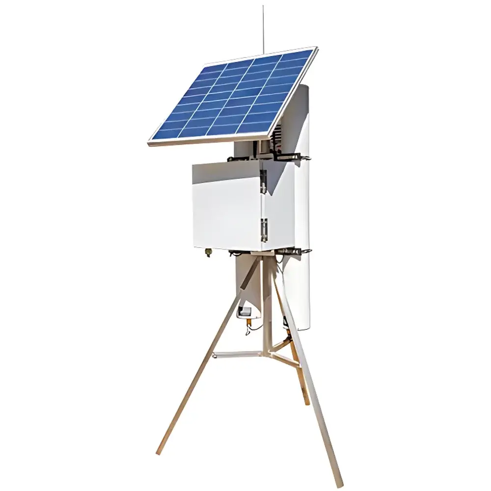
The Pri-eco CRS-2000C Cosmic-Ray Neutron Sensing (CRNS) Soil Moisture Measurement System is a field-deployable, passive geophysical instrument engineered for continuous, non-invasive estimation of areal-average soil water content over intermediate spatial scales (up to 700 m diameter, ~350 m radius). It operates on the well-established physical principle of cosmic-ray neutron moderation: high-energy neutrons generated by galactic cosmic rays interact with atomic nuclei in the atmosphere and near-surface environment; upon encountering hydrogen-rich materials—primarily bound hydrogen in soil water—these neutrons undergo elastic scattering, lose kinetic energy, and become “fast” (epithermal) neutrons. A fraction of these fast neutrons escapes upward and reaches equilibrium flux levels just above the ground surface. The intensity of this epithermal neutron flux exhibits an inverse, empirically calibrated relationship with volumetric water content in the top ~70 cm of soil. Unlike point-scale probes (e.g., TDR, FDR, capacitance sensors), the CRS-2000C integrates moisture information across heterogeneous landscapes without soil disturbance, electrode insertion, or calibration dependency on soil texture, bulk density, or electrical conductivity. Its measurement footprint bridges the gap between in situ sensor networks and satellite-based remote sensing—offering representative, physics-based soil moisture data critical for hydrological modeling, land-atmosphere coupling studies, and operational water resource management.
Key Features
- Passive cosmic-ray neutron sensing technology—no radioactive source, no electromagnetic emission, fully compliant with IAEA safety guidelines for unattended environmental monitoring.
- Non-contact, non-destructive operation—mounted above-ground on masts, vehicles, or UAV platforms; eliminates installation labor, soil compaction artifacts, and long-term drift associated with buried sensors.
- Robust sensitivity to hydrogen concentration—primarily from soil water, with minimal interference from soil salinity, clay content, organic matter variability, or surface roughness.
- Integrated environmental compensation suite: co-located high-accuracy temperature (±1 °C), relative humidity (~±3% RH), and barometric pressure (±0.01 hPa) sensors enable real-time atmospheric correction per ISO 18405 and COSMOS-EPIC protocols.
- Modular architecture supporting rover-mounted (vehicle-based), fixed-station, and low-altitude airborne deployment configurations—enabling flexible scaling from farm-field to watershed-level observation.
- Industrial-grade data acquisition unit: 32-bit ARM processor (300 MHz), triple-isolated digital I/O (RS232, RS485, TTL), dual DC power outputs (12 V / 2 A and 5 V / 2 A) for external sensor integration, and built-in surge/lightning protection per IEC 61000-4-5 Level 4.
Sample Compatibility & Compliance
The CRS-2000C is validated for use across diverse pedoclimatic conditions—including arid, semi-arid, temperate, and alpine environments—and has been deployed in USDA ARS, NOAA NWS, and EU COST Action ES1301 field campaigns. Its measurement methodology adheres to the internationally recognized CRNS standardization framework developed under the Cosmic-Ray Soil Moisture Observing System (COSMOS) initiative and referenced in ASTM D8295–21 (Standard Guide for Cosmic-Ray Neutron Probe Use in Hydrologic Monitoring). The system meets CE marking requirements for electromagnetic compatibility (EMC Directive 2014/30/EU) and low-voltage safety (LVD Directive 2014/35/EU). Data logging and transmission support GLP-compliant metadata tagging, including GPS-derived location, UTC timestamping, and sensor health diagnostics—essential for regulatory reporting under EPA Method 1600 and FAO Water Productivity Monitoring frameworks.
Software & Data Management
Data acquisition is managed via embedded Linux-based firmware supporting programmable sampling intervals from 1 minute to 1 year. Raw neutron counts, environmental parameters, and diagnostic flags are stored on internal 32 GB microSD card with hot-swap capability. All data are formatted in CF-compliant NetCDF-4 with CF-1.8 metadata conventions, enabling seamless ingestion into hydrological modeling platforms (e.g., SWAT, VIC, Noah-MP). Optional cloud synchronization uses TLS 1.2-encrypted MQTT or HTTP(S) protocols through integrated LTE Cat-4 (4G) module with global band support (B1/B3/B5/B7/B8/B20/B28). Firmware updates and configuration changes are remotely executable via secure SSH or web-based REST API. Audit trails—including user access logs, parameter modification history, and firmware versioning—are retained for FDA 21 CFR Part 11–aligned validation workflows when used in agricultural water stewardship programs subject to USDA NRCS EQIP verification.
Applications
- Calibration and validation of satellite-derived soil moisture products (e.g., SMAP, SMOS, Sentinel-1) at landscape scale.
- Ground-truthing for eddy covariance towers—providing spatially integrated moisture constraints for partitioning evapotranspiration fluxes.
- Operational irrigation scheduling across precision agriculture zones—supporting variable-rate application based on real-time areal water deficit indices.
- Drought early warning systems—feeding regional drought severity indices (e.g., USDM, SPI-6) with physically consistent, sub-daily moisture time series.
- Snow water equivalent (SWE) estimation—leveraging complementary slow-neutron detection mode for seasonal snowpack monitoring in mountainous catchments.
- Hillslope stability assessment and flash flood forecasting—integrating near-real-time moisture dynamics into hydro-mechanical slope failure models (e.g., TRIGRS, SHALSTAB).
FAQ
How does the CRS-2000C differ from traditional point-scale soil moisture sensors?
It measures the epithermal neutron flux modulated by hydrogen in the top ~70 cm across a circular area up to 700 m in diameter—providing a spatially integrated value rather than a localized point reading.
Does soil salinity affect measurement accuracy?
No—cosmic-ray neutron moderation is dominated by elastic scattering with hydrogen nuclei; ionic conductivity or dissolved salt concentration has negligible influence on neutron energy loss cross-sections.
Can the system operate autonomously in remote locations?
Yes—standard configuration includes solar charging controller, deep-cycle battery interface, and 4G telemetry; field deployments exceeding 12 months without maintenance have been documented in USDA Long-Term Agroecosystem Research (LTAR) sites.
Is calibration required for different soil types?
A single site-specific calibration is recommended during initial commissioning using concurrent gravimetric sampling or neutron probe profiles; thereafter, no re-calibration is needed due to the physics-based hydrogen sensitivity.
What meteorological corrections are applied in real time?
Barometric pressure, air temperature, and relative humidity are continuously measured and applied using the standardized N0 correction algorithm described in Desilets et al. (2010) and updated in the COSMOS-EPIC v2.0 processing pipeline.
Related Products