Ecodrone®-Kestrel AisaKestrel-Based High-Resolution UAV Hyperspectral Remote Sensing System
| Origin | Shaanxi, China |
|---|---|
| Manufacturer Type | Authorized Distributor |
| Origin Category | Domestic |
| Model | Ecodrone®-Kestrel |
| Pricing | Upon Request |
| Operating Principle | Push-broom |
| Imaging Method | Dispersive (Prism-based) |
| Deployment Mode | Ground-based & Airborne Compatible |
| Spectral Range | 400–1000 nm |
| Spectral Resolution | 2.6 nm (FWHM) |
| Spatial Resolution (Detector Array) | 2048 pixels per line |
| Total Field of View (TFOV) | 40° |
| Instantaneous Field of View (IFOV) | 2048 × 1 pixel array (sensor-native sampling) |
| Frame Rate | 100 Hz |
Overview
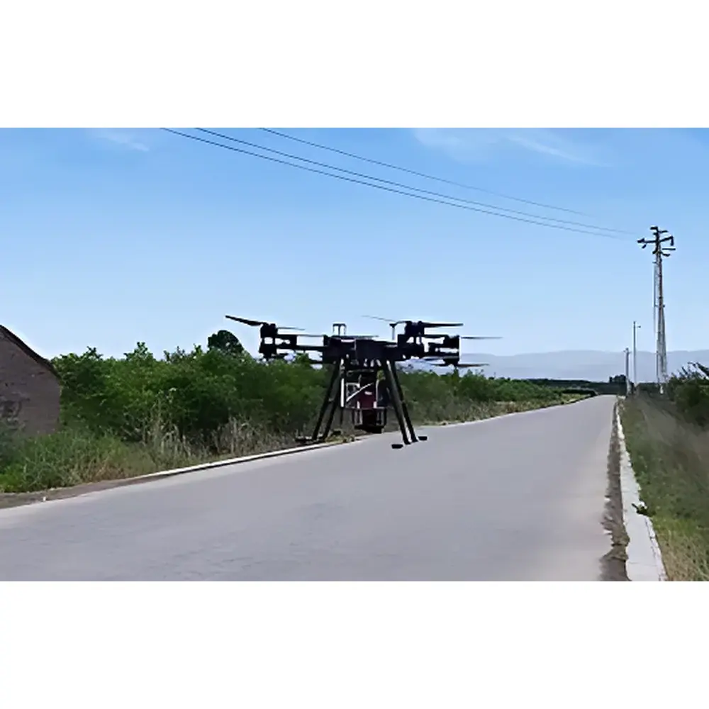
The Ecodrone®-Kestrel is a research-grade unmanned aerial vehicle (UAV)-borne hyperspectral remote sensing system engineered for quantitative, spatially resolved spectral analysis across terrestrial and ecological domains. Built upon the Ecodrone® UAS-8 Pro high-payload UAV platform and integrated with the Specim AisaKestrel hyperspectral imaging sensor—a push-broom, prism-dispersive spectrometer—the system acquires contiguous, high-fidelity reflectance data across the visible to near-infrared (VNIR) spectrum (400–1000 nm). Its core measurement principle relies on calibrated radiometric capture of scene-reflected photons at 2.6 nm spectral resolution, enabling precise derivation of narrowband vegetation indices (e.g., NDVI, PSRI, PRI), mineral absorption features, and water quality proxies. Designed for reproducible field deployment, the system supports both airborne survey operations and ground-based stationary or mobile mounting—facilitating cross-platform validation and multi-scale data fusion in environmental monitoring workflows.
Key Features
- High-spatial-fidelity acquisition: 2048-pixel linear array detector ensures fine-grained spatial sampling across a 40° total field of view, optimized for sub-meter ground sampling distance (GSD) at typical operational altitudes (60–200 m AGL).
- Push-broom architecture with real-time frame synchronization: Enables geometrically stable, distortion-minimized image cubes; 100 Hz acquisition rate supports dynamic flight speeds up to 12 m/s without motion blur under standard illumination.
- Integrated thermo-RGB co-mounting capability: Simultaneous acquisition of registered hyperspectral, thermal infrared (LWIR/MWIR), and true-color RGB imagery via synchronized trigger and geotagging—critical for multi-modal phenotyping and energy balance modeling.
- Radiometric calibration traceable to NIST standards: Factory-calibrated using integrating sphere sources; onboard dark current and flat-field correction routines ensure long-term measurement stability across diurnal and seasonal field campaigns.
- Ruggedized UAV integration: Vibration-damped gimbal mount, IP54-rated enclosure, and CAN/RS-422 telemetry interface compatible with Pixhawk- and DJI-based autopilot systems.
Sample Compatibility & Compliance
The Ecodrone®-Kestrel is validated for non-contact, non-destructive spectral characterization of heterogeneous natural surfaces—including crop canopies, forest stands, soil substrates, inland water bodies, and mineral outcrops. Its VNIR spectral response aligns with key ASTM standards for vegetation reflectance measurement (ASTM E2937-22), water quality spectral proxy development (ASTM D8292-22), and geological spectral library referencing (ASTM D7662-21). Data output formats (ENVI .hdr/.bil, GeoTIFF with embedded RPC metadata) comply with ISO 19115 geospatial metadata requirements. The system supports GLP-aligned field data acquisition protocols, including timestamped calibration log recording, operator ID tagging, and GPS/IMU-augmented georeferencing essential for regulatory-grade environmental reporting.
Software & Data Management
Data acquisition is managed via Specim’s INSIGHT software suite, supporting real-time preview, exposure optimization, and on-board storage (up to 2 TB SSD). Post-processing leverages ENVI, Python-based spectral libraries (scikit-learn, Spectral Python), and custom MATLAB toolboxes for atmospheric correction (QUAC, FLAASH), endmember extraction (N-FINDR), and index mapping (NDVI, PSRI, MCARI, WI). All raw and processed datasets support audit trails compliant with FDA 21 CFR Part 11 when deployed in GxP-regulated agricultural trials—enabling electronic signature, user access control, and immutable version history within enterprise LIMS environments.
Applications
- High-throughput plant phenotyping: Quantitative assessment of canopy chlorophyll content, nitrogen status, water stress, and senescence progression across breeding plots—validated in winter wheat growth-stage classification (jointing to harvest maturity) using time-series PSRI and NDVI dynamics.
- Forest health and biodiversity mapping: Species-level discrimination via spectral unmixing; detection of early-stage pest infestation and drought-induced physiological decline through red-edge and NIR slope anomalies.
- Aquatic ecosystem monitoring: Retrieval of chlorophyll-a concentration, suspended sediment load, and CDOM absorption coefficients from coastal and inland waters using band-ratio algorithms trained on in-situ spectroradiometer ground truth.
- Geological and soil resource surveying: Identification of clay mineral assemblages (kaolinite, smectite), iron oxide/hydroxide distributions, and hydrocarbon seepage signatures via diagnostic absorption features near 700 nm, 920 nm, and 1400 nm.
- Urban land-cover classification and impervious surface mapping: Sub-pixel fractional abundance estimation for green infrastructure planning and stormwater runoff modeling.
FAQ
What spectral calibration standards are supported?
The AisaKestrel sensor includes factory radiometric and spectral calibration certificates traceable to NIST SRM 2035 and 2036. On-site recalibration is supported using portable integrating spheres (e.g., Labsphere Spectralon panels) and solar reference measurements.
Is the system compatible with third-party UAV platforms beyond Ecodrone® UAS-8 Pro?
Yes—mechanical, power, and data interfaces follow industry-standard UAV integration guidelines (MAVLink-compatible telemetry, 12–24 V DC input, GigE Vision protocol); integration kits and mounting templates are available for DJI Matrice 300 RTK and Freefly Alta X platforms.
How is georeferencing accuracy ensured during flight?
Integrated dual-frequency GNSS (GPS + GLONASS + Galileo) with RTK/PPK post-processing achieves ≤5 cm horizontal positional accuracy; IMU data (±0.01° roll/pitch) is fused with optical flow for robust attitude stabilization under low-texture terrain conditions.
Can the system operate under variable illumination conditions?
Yes—the sensor’s auto-exposure algorithm dynamically adjusts integration time per line scan; additionally, the system supports synchronized irradiance measurement via an optional downwelling light sensor (DLS) for absolute reflectance conversion.
What data security and export compliance measures apply?
All firmware and software comply with EAR99 export control classification; no encryption modules requiring BIS license are embedded. Raw hyperspectral data files contain no embedded PII or classified geolocation metadata by default—custom metadata schemas may be configured per institutional IRB or national remote sensing policy requirements.


")
