UGT SUSTRA Aeolian Erosion Monitoring System
| Brand | UGT |
|---|---|
| Origin | Germany |
| Manufacturer Type | Authorized Distributor |
| Product Origin | Imported |
| Model | SUSTRA Aeolian Erosion Monitoring System |
| Pricing | Upon Request |
Overview
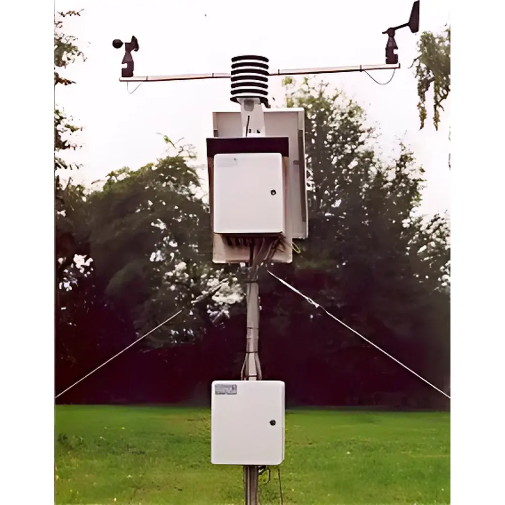
The UGT SUSTRA Aeolian Erosion Monitoring System is a field-deployable, automated instrumentation platform engineered for quantitative measurement of wind-driven soil particle transport—specifically the erosion, suspension, and deposition of medium-to-fine sand fractions (63–500 µm) under natural atmospheric conditions. Based on the principle of gravimetric sediment flux quantification, the system integrates a motorized, wind-direction-responsive sediment collector with high-precision electronic balance (0.1 g resolution), time-synchronized data acquisition, and co-located meteorological sensing. It operates continuously at user-defined intervals (default 5-minute sampling), enabling long-term monitoring of erosion onset timing, event intensity, cumulative sediment mass, and dynamic coupling with concurrent micrometeorological drivers—including wind speed and direction, air temperature and relative humidity, solar radiation, precipitation, soil moisture and temperature, and barometric pressure. Designed in accordance with internationally referenced aeolian measurement protocols—including BS 1747 Part 5 for multi-directional dust flux collection—the system supports both research-grade process studies and operational land degradation assessment in arid, semi-arid, and cultivated ecosystems.
Key Features
- Automated, azimuth-adjusting sediment collector with real-time wind-vane feedback to maintain optimal inlet orientation relative to prevailing flow
- Gravimetric quantification via integrated precision balance (0–1200 g range, ±0.1 g repeatability), housed in thermally stabilized outdoor enclosure
- Modular, expandable architecture supporting up to four vertical sampling heights (MWAC gradient configuration) or directional quadrants (four-way flux towers)
- Configurable inlet geometry: 50 mm internal diameter, 23 cm height; adjustable burial depth enables precise control of sampling height above ground surface (e.g., 0.1 m to 2.0 m AGL)
- 80-day continuous operation capability (at 5-min interval) with onboard RAM data storage and optional SD card backup
- Compliance-ready data structure compatible with GLP-aligned metadata tagging (timestamp, GPS coordinates, sensor IDs, calibration status)
Sample Compatibility & Compliance
The system is validated for collection and mass quantification of airborne mineral particles within the medium-to-fine sand fraction (63–500 µm), with demonstrated collection efficiency ≥80% under field-representative turbulent boundary layer conditions. All mechanical components—including anodized aluminum deposition cylinders (227 mm diameter, 5 L capacity) and stainless-steel MWAC intake manifolds (7.5 mm ID)—are corrosion-resistant and inert to common soil-derived aerosols. The four-way flux tower conforms to British Standard BS 1747 Part 5 for directional dust sampling. Optional integration with the Sedimat laser diffraction particle size analyzer enables post-collection granulometric analysis per ISO 13320, facilitating correlation of transport dynamics with grain-size distribution and threshold friction velocity modeling. Data output formats support interoperability with ISO/IEC 17025-accredited laboratory information management systems (LIMS).
Software & Data Management
Data acquisition is managed by UGT’s proprietary FieldLog™ firmware, supporting configurable sampling schedules, alarm-triggered high-frequency logging, and automatic synchronization across distributed sensors. Raw outputs include timestamped mass increments (g), wind vector components (m s⁻¹, °), environmental variables (°C, %RH, W m⁻², mm h⁻¹), and diagnostic flags (e.g., balance drift, power interruption, sensor timeout). Export options include CSV, NetCDF, and XML with embedded CF-compliant metadata. Optional cloud-based dashboard (UGT CloudLink™) provides remote access, QA/QC visualization tools, and audit-trail generation compliant with FDA 21 CFR Part 11 requirements for electronic records and signatures. Firmware updates are delivered via secure OTA protocol with cryptographic signature verification.
Applications
- Long-term monitoring of land degradation and desertification progression in dryland agroecosystems
- Validation and parameterization of wind erosion models (e.g., WEPS, RWEQ, SWEEP)
- Evaluation of conservation tillage efficacy, vegetation cover impact, and soil surface crusting dynamics
- Source identification and spatial heterogeneity mapping of dust emission hotspots using multi-tower deployments
- Supporting IPCC AR6 land-use change reporting and UNCCD national action program indicators
- Calibration and intercomparison studies for satellite-based dust aerosol retrieval algorithms (e.g., MODIS, VIIRS)
FAQ
What is the minimum detectable sediment mass increment?
The system resolves mass changes ≥0.1 g per sampling interval; at 5-minute intervals, this corresponds to a minimum detectable flux of ~0.03 g m⁻² h⁻¹ over standard 0.05 m² inlet area.
Can the system operate unattended for extended periods in extreme environments?
Yes—enclosures meet IP67 rating; operating temperature range is –30°C to +60°C; all sensors are rated for continuous outdoor exposure including UV resistance and freeze-thaw cycling.
Is calibration traceable to national metrology institutes?
Electronic balances are factory-calibrated against certified weights traceable to PTB (Physikalisch-Technische Bundesanstalt, Germany); meteorological sensors carry individual calibration certificates compliant with ISO/IEC 17025.
How is data integrity ensured during power outages or communication failures?
Onboard non-volatile memory retains all measurements; internal rechargeable battery sustains critical functions (clock, memory, low-power sensors) for >72 hours; data sync resumes automatically upon recovery.
Does the system support integration with third-party telemetry or SCADA platforms?
Yes—RS-485 Modbus RTU and Ethernet TCP/IP interfaces enable direct integration with industry-standard SCADA systems, LoRaWAN gateways, or cellular IoT hubs via optional communication modules.
Related Products


