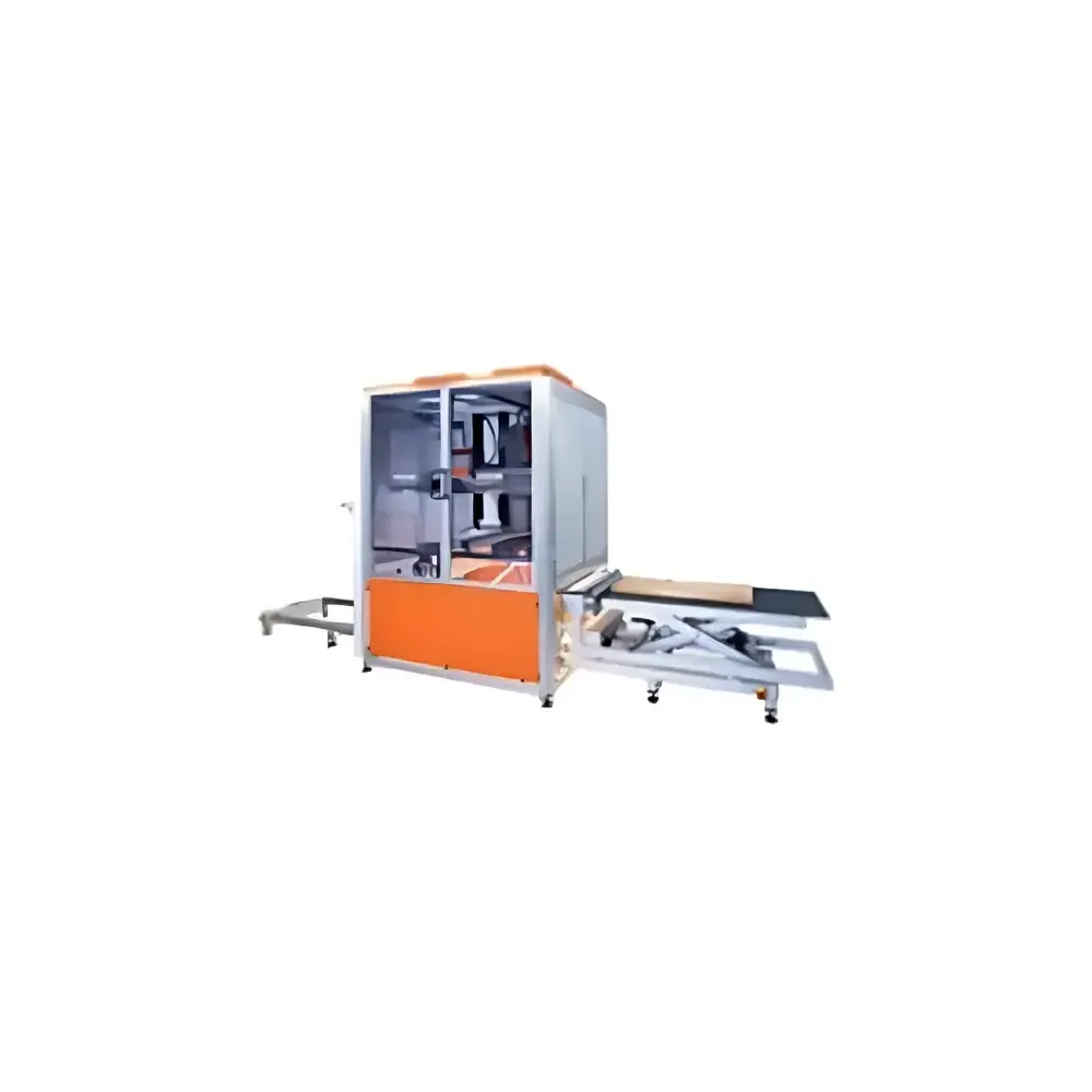
Specim SISUROCK Fully Automated Core & Rock Hyperspectral Imaging Workstation
| Brand | Specim |
|---|---|
| Origin | Finland |
| Distributor Type | Authorized Distributor |
| Origin Category | Imported |
| Model | SISUROCK Fully Automated |
| Pricing | Available Upon Request |
Overview
The Specim SISUROCK Fully Automated Core & Rock Hyperspectral Imaging Workstation is an industrial-grade, turnkey solution engineered for high-throughput, non-destructive mineralogical characterization of drill core and rock samples. Built upon push-broom hyperspectral imaging (HSI) technology, the system captures spatially resolved spectral data across contiguous wavelength bands—spanning VNIR (400–1000 nm), SWIR (1000–2500 nm), and optionally MWIR/LWIR ranges—enabling pixel-level identification and quantification of mineral assemblages based on diagnostic absorption features. Unlike conventional point-spectroscopy or XRD-based methods, SISUROCK delivers continuous, meter-scale spectral cubes without sample sectioning, grinding, or chemical treatment, preserving geological context while supporting rapid digital logging in exploration, resource estimation, and mine planning workflows.
Key Features
- Fully automated linear scanning architecture with integrated conveyor, precision core positioning, and real-time illumination control for consistent radiometric calibration across variable core diameters (30–150 mm) and surface conditions.
- Multi-sensor modularity: Standard configuration includes synchronized VNIR and SWIR cameras; optional MWIR/LWIR modules enable expanded spectral coverage for sulfide, carbonate, and clay mineral discrimination.
- Onboard spectral preprocessing: Real-time dark-current correction, flat-field normalization, and geometric rectification ensure traceable data quality compliant with ISO 17025 laboratory practices.
- Ruggedized industrial enclosure rated IP54, designed for operation in core logging facilities, mobile labs, or near-mine site environments with ambient temperature stability (15–30 °C) and humidity control (30–60% RH).
- Integrated core metadata tagging: Automatic association of spectral data with depth, orientation, lithology codes, and georeferenced borehole IDs via industry-standard formats (e.g., LIS, DLIS, or CSV-compatible export).
Sample Compatibility & Compliance
SISUROCK accommodates uncut, unwashed, and uncoated drill core segments up to 2 m in length and 150 mm in diameter—including soft sediments, fractured metamorphic rocks, and weathered ore zones—without requiring epoxy impregnation or slabbing. The system complies with ASTM D6913 (Standard Test Methods for Particle-Size Distribution of Soil), ISO 14688-1 (Geotechnical Investigation and Testing — Identification and Classification of Soil), and supports GLP-aligned data integrity through audit-trail-enabled acquisition logs. All spectral libraries used for mineral classification are traceable to the USGS Spectral Library v7 and the ECOSTRESS Mineral Library, with spectral matching algorithms validated per ISO/IEC 17025 clause 7.2.2 (Method Validation).
Software & Data Management
The workstation operates with Specim’s proprietary SISUView software suite, which provides end-to-end processing from raw cube ingestion to mineral map generation. Key capabilities include spectral angle mapper (SAM), constrained energy minimization (CEM), and machine learning–assisted classification (e.g., Random Forest trained on field-validated reference spectra). Export formats include GeoTIFF (with embedded coordinate systems), ENVI .hdr/.dat, and HDF5 for integration into Petrel, Leapfrog Geo, or Python-based geospatial analysis pipelines. Data provenance is preserved via embedded EXIF-like metadata, including acquisition time, sensor temperature, integration time, and calibration status—all accessible programmatically via REST API. Software validation documentation supports FDA 21 CFR Part 11 compliance for regulated QA/QC environments.
Applications
- Exploration geochemistry: Rapid lithological mapping and alteration zonation (e.g., phyllic, argillic, propylitic) across large core libraries.
- Ore grade estimation: Semi-quantitative assessment of hematite, goethite, jarosite, and alunite abundances correlated with assay data.
- Deposit modeling: Integration of mineral maps with structural interpretations to constrain fluid flow pathways and hydrothermal system evolution.
- Core archive digitization: Long-term preservation of spectral signatures for retrospective re-analysis as new mineral models emerge.
- Academic research: Calibration of remote sensing products (e.g., Sentinel-2, PRISMA) using ground-truth core spectra.
FAQ
What spectral ranges does the standard SISUROCK configuration cover?
The base system includes VNIR (400–1000 nm) and SWIR (1000–2500 nm) sensors. MWIR (3–5 µm) and LWIR (8–12 µm) modules are available as configurable options.
Can SISUROCK analyze partially weathered or coated core surfaces?
Yes—its illumination geometry and spectral unmixing algorithms are optimized to mitigate effects of thin oxidation layers, dust, or minor bitumen coatings without pre-treatment.
How is mineral identification accuracy validated?
Validation follows a dual-path approach: (1) comparison against XRD/XRF reference measurements on subsampled intervals, and (2) cross-validation using blind test sets from independent drill programs with known geological context.
Is the system compatible with existing core logging databases?
Yes—SISUView supports direct import/export of LIS/DLIS files and offers configurable mapping to custom database schemas via XML or JSON configuration templates.
What level of technical support is provided post-installation?
Specim-certified engineers deliver on-site commissioning, operator training, and annual preventive maintenance; remote diagnostics and software updates are included under the standard service agreement.