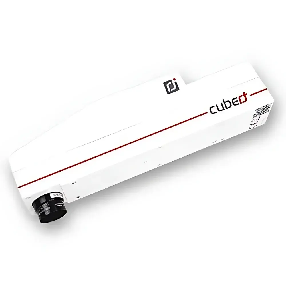
Cubert S485 Airborne Snapshot Hyperspectral Imaging Spectrometer
| Brand | Cubert |
|---|---|
| Origin | Germany |
| Model | S485 |
| Spectral Range Options | 350–800 nm |
| Spectral Resolution | 10 nm @ 532 nm |
| Spatial Resolution (IFOV) | Configurable |
| Field of View (TFOV) | Configurable |
| Imaging Format | 2 × 1.0 MP Frame-Based Simultaneous Capture |
| Frame Rate | 20 Hyperspectral Cubes/s |
| Spectral Sampling Interval | 4.5 nm |
| Detector | Dual Si CCD Array |
| Bit Depth | 12-bit |
| Exposure Time | 0.1–1000 ms |
| Interface | Dual Gigabit Ethernet |
| Shutter Type | Global Shutter |
| Lens Options | 10 mm / 23 mm / 35 mm |
| Operating Temperature | −10 to +50 °C |
| Weight | 2000 g |
| Power Supply | DC 12 V, 15 W |
Overview
The Cubert S485 is a frame-based airborne hyperspectral imaging spectrometer engineered for high-fidelity, motion-robust spectral data acquisition in dynamic remote sensing environments. Unlike push-broom or scanning systems, the S485 employs snapshot hyperspectral imaging—capturing full spatial-spectral data cubes (x, y, λ) simultaneously within a single integration period. This eliminates motion-induced artifacts, spatial misregistration, and temporal inconsistencies inherent in line-scanning architectures. The instrument operates on the principle of image-splitting dispersive spectroscopy: incident light is divided into two parallel optical paths, each directed onto a dedicated silicon CCD sensor array; one captures spatial information while the other records dispersed spectral content, enabling real-time reconstruction of calibrated hyperspectral cubes at up to 20 cubes per second. Its solid-state, no-moving-parts design ensures mechanical stability during UAV deployment, vibration resilience, and long-term calibration retention—critical for GLP-compliant field campaigns and time-series monitoring.
Key Features
- True snapshot acquisition: Full 2D spatial + spectral cube capture in ≤1 ms—enabling artifact-free imaging from moving platforms including multirotor and fixed-wing UAVs.
- Dual Si CCD architecture: Two synchronized 1.0 MP sensors provide redundant signal paths, enhancing SNR and enabling on-the-fly dark-current correction and flat-field normalization.
- Configurable spectral bands: Three factory-selectable spectral ranges (350–800 nm, 450–950 nm, 600–1000 nm) with 125 spectral channels and 4.5 nm sampling interval; spectral resolution maintained at 10 nm FWHM at 532 nm.
- Integrated real-time preview: Onboard FPGA-accelerated processing enables ground-station video-rate display of RGB-composite and false-color index maps via Wi-Fi telemetry—no external IMU required for georeferencing in basic survey modes.
- Modular optical interface: Interchangeable C-mount lenses (10 mm, 23 mm, 35 mm) allow optimization of instantaneous field of view (IFOV) and ground sampling distance (GSD) across flight altitudes from 30 m to 500 m.
- Industrial-grade interface suite: Dual GigE ports support synchronized data streaming and command/control; 12-bit digitization ensures >73 dB dynamic range for quantitative reflectance modeling.
Sample Compatibility & Compliance
The S485 is designed for non-contact, passive reflectance measurement of natural and anthropogenic surfaces under ambient solar illumination. It complies with ISO 17025 traceability frameworks when used with NIST-traceable calibration panels (e.g., Spectralon®). While not certified for regulatory submission per se, its radiometric stability, spectral repeatability (<0.3% RMS drift over 8 h), and metadata-rich output (embedded GPS/IMU timestamps, exposure logs, temperature compensation flags) align with FAO’s guidelines for agricultural monitoring and ESA’s CEOS calibration protocols. The system supports ASTM E2792-21 (Standard Practice for Hyperspectral Imaging Data Acquisition) and is routinely deployed in USDA-ARS and EU H2020 environmental observatory networks under documented SOPs.
Software & Data Management
Acquisition and processing are managed via Cubert’s native HyperSpectra Studio, a Windows-based application supporting batch-calibration, atmospheric correction (using MODTRAN-derived LUTs), geometric rectification, and vegetation index computation (NDVI, NDRE, PRI, MCARI, etc.). All core algorithms—including spectral unmixing (NNLS), endmember extraction (VCA), and classification (SVM, RF)—are accessible via Python API (PyCubert), which exposes low-level device control, raw cube I/O, and metadata serialization (UTF-8 JSON + ENVI header). Data export conforms to HDF5 v1.12 and GeoTIFF standards with embedded GDAL-compatible georeferencing tags. Audit trails, user authentication, and configurable logging meet FDA 21 CFR Part 11 requirements for electronic records when deployed in GxP-aligned research settings.
Applications
- Agricultural monitoring: High-throughput phenotyping, nitrogen status mapping, early stress detection (water, nutrient, pathogen), and yield prediction at plot-to-field scale.
- Environmental assessment: Wetland delineation, invasive species mapping, soil organic carbon estimation, and post-wildfire burn severity analysis.
- Cultural heritage: Pigment identification in frescoes, manuscript degradation tracking, and subsurface feature enhancement in aerial archaeological surveys.
- Forestry: Species discrimination, canopy health stratification, and biomass estimation using red-edge and NIR absorption features.
- Urban remote sensing: Material classification (roof types, pavement conditions), heat island effect modeling, and impervious surface quantification.
- Defense & security: Camouflage detection, concealed object identification, and change detection in time-series orthomosaic stacks.
FAQ
Does the S485 require an external IMU for georeferencing?
No—its snapshot architecture enables direct geo-registration using onboard GNSS timestamps and known platform pose (if available); for UAV applications without IMU, co-registration relies on ground control points and structure-from-motion (SfM) workflows in post-processing.
Can spectral calibration be performed in-field?
Yes—users may acquire reference panel measurements at any time; the software applies multiplicative correction using pre-characterized relative spectral response (RSR) curves stored in the instrument’s EEPROM.
Is radiometric calibration traceable to NIST standards?
Factory calibration uses NIST-traceable integrating sphere sources; end-users receive a certificate of conformance with uncertainty budget per ISO/IEC 17025 Annex A.
What file formats does the system natively export?
Raw cubes (.cub), calibrated reflectance stacks (.h5), GeoTIFF mosaics, and ENVI-compatible BIL/BIP files—with optional EXIF/XMP metadata embedding.
How is thermal drift compensated during extended flights?
Internal thermistors monitor detector and optics housing temperatures; real-time gain-offset adjustments are applied using polynomial coefficients derived from lab-based thermal characterization (−10°C to +50°C).
Related Products

")