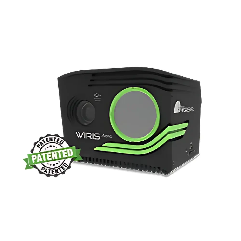
Workswell Agro Moisture Stress Index Imaging System
| Brand | Workswell |
|---|---|
| Origin | Czech Republic |
| Model | Agro |
| Detector Type | Uncooled Microbolometer (LWIR) |
| Spectral Range | 7.5–13.5 µm (LWIR) |
| Thermal Sensitivity (NETD) | ≤30 mK @ 30 °C |
| IR Resolution | 1920 × 1080 FHD |
| Temperature Range | −10 °C to +55 °C |
| Accuracy | ±0.5 °C (calibrated over full range) |
| Frame Rate | 30 Hz (full resolution) |
| Measurement Method | Non-contact infrared thermography |
| Application Type | Agricultural monitoring and phenotyping |
| Optical Zoom | 10× (integrated RGB camera, 1920 × 1080) |
| Image Processing Features | Auto white balance, WDR, backlight compensation, adjustable exposure & gamma curve |
| Connectivity | Wi-Fi (low-latency streaming & command control), Ethernet (RJ-45), S.Bus/CAN (DJI M600/A3 compatible), MAVLink, External GPS input, External trigger support |
Overview
The Workswell Agro Moisture Stress Index Imaging System is a purpose-built, high-resolution long-wave infrared (LWIR) thermal imaging platform engineered for precision agriculture applications. Unlike conventional vegetation indices relying solely on reflectance in visible and near-infrared (NIR) bands, the Agro system quantifies plant physiological response to water deficit by measuring canopy temperature dynamics—directly linked to stomatal conductance and transpiration efficiency. Operating within the 7.5–13.5 µm spectral window, it captures subtle thermal gradients across crop canopies with a thermal sensitivity of ≤30 mK and calibrated accuracy of ±0.5 °C across its full operational range (−10 °C to +55 °C). Its native 1920 × 1080 LWIR resolution—paired with a synchronized 10× optical zoom RGB imager—enables pixel-level co-registration of thermal and visual data, supporting robust spatial mapping of moisture stress at field and sub-field scales. Designed for integration into aerial survey workflows, the Agro system delivers actionable biophysical metrics—not just color or reflectance anomalies—but actual plant water status derived from first-principles thermophysiology.
Key Features
- Full HD LWIR imaging (1920 × 1080 pixels) with uncooled microbolometer detector optimized for agricultural thermal contrast
- Synchronized 10× optical zoom RGB camera for precise georeferenced overlay and contextual interpretation
- Real-time thermal video streaming via low-latency Wi-Fi (H.264/H.265) and bidirectional command interface
- Industrial-grade connectivity suite: Ethernet (RJ-45), S.Bus/CAN bus (DJI A3/M600 compatible), MAVLink telemetry, external GPS input, and hardware trigger support
- Onboard image processing engine enabling auto white balance, wide dynamic range (WDR), backlight compensation, and user-adjustable exposure/gamma parameters
- Ruggedized enclosure rated for outdoor deployment; operating temperature range −10 °C to +55 °C
Sample Compatibility & Compliance
The Agro system is validated for use across major agronomic species—including maize, wheat, soybean, vineyards, and orchard crops—under both open-field and controlled-environment conditions. Its non-contact measurement methodology complies with ISO 18434-1:2008 (Condition monitoring and diagnostics of machines — Thermography — Part 1: General procedures) for thermal assessment of biological surfaces. While not a medical or industrial safety device, its radiometric calibration traceability aligns with NIST-traceable reference sources, and raw thermal data output supports audit-ready documentation required under GLP-aligned field trials. The system does not require sample preparation, consumables, or physical contact—making it suitable for repeated longitudinal monitoring without plant disturbance.
Software & Data Management
Agro Analyzer software serves as the dedicated processing and analytics environment for Agro-generated datasets. It implements the proprietary Moisture Stress Index (MSI) algorithm, which normalizes canopy temperature against reference wet/dry baselines derived from concurrent meteorological inputs and vegetation structure models. The software supports batch processing of hundreds of geotagged thermal-RGB image pairs, automatic orthorectification when paired with RTK-GPS metadata, and export of MSI rasters in GeoTIFF format compliant with GDAL/OGR standards. All processing steps—including ROI definition, emissivity correction, atmospheric compensation, and index calculation—are fully logged with timestamped audit trails. Exported maps are compatible with GIS platforms (QGIS, ArcGIS) and farm management systems (e.g., Climate FieldView™, Granular™) via standard shapefile and CSV interfaces. Software updates and calibration patches are delivered through secure HTTPS channels, with version history and change logs maintained per ISO/IEC 17025 documentation requirements.
Applications
- High-resolution spatial mapping of crop water stress for irrigation scheduling and deficit irrigation optimization
- Early detection of drought-induced physiological decline prior to visible symptom onset
- Yield potential estimation through empirical correlation between MSI and harvest data across growing seasons
- Evaluation of rootstock performance, drought-tolerant cultivar screening, and breeding trial phenotyping
- Validation of soil moisture models and evapotranspiration (ET) estimates from satellite or weather station data
- Post-intervention assessment of irrigation infrastructure upgrades, mulching efficacy, or soil amendment trials
FAQ
How does the Agro MSI differ from NDVI?
The Agro Moisture Stress Index is a physiology-based metric derived from canopy temperature, reflecting real-time stomatal regulation and evaporative cooling capacity. NDVI measures spectral reflectance differences (red vs. NIR) and correlates with chlorophyll content and leaf area—making it sensitive to structural changes but blind to early water stress before visible wilting occurs.
Can Agro be mounted on fixed-wing UAVs?
Yes—the system’s compact form factor (≤1.2 kg), dual-band synchronization, and MAVLink/Ethernet interfaces ensure compatibility with Class I and II fixed-wing and multirotor platforms certified for agricultural remote sensing.
Is radiometric calibration required before each flight?
No—factory calibration is NIST-traceable and stable over time. Users perform optional in-field blackbody validation using the included portable reference source (optional accessory) for mission-critical trials requiring <±0.3 °C uncertainty.
Does Agro Analyzer support automated cloud processing?
Agro Analyzer operates locally on Windows 10/11 workstations. Cloud-based batch processing is available via Workswell’s secure SaaS portal (AgroCloud), with encrypted data transfer and GDPR-compliant storage.
What metadata standards does Agro support?
Exif, XMP, and GeoTIFF tags include GPS position, altitude, IMU orientation, UTC timestamp, sensor temperature, lens focal length, and emissivity assumptions—fully compliant with ISO 19115 geospatial metadata schema.