AZUP A660B UAV-Based BRDF Measurement System
| Brand | AZUP |
|---|---|
| Origin | Beijing, China |
| Manufacturer Type | Original Equipment Manufacturer (OEM) |
| Product Category | Domestic |
| Model | A660B UAV-Based BRDF Data Acquisition System |
| Pricing | Upon Request |
Overview
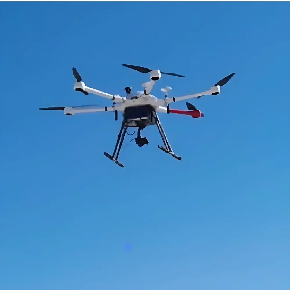
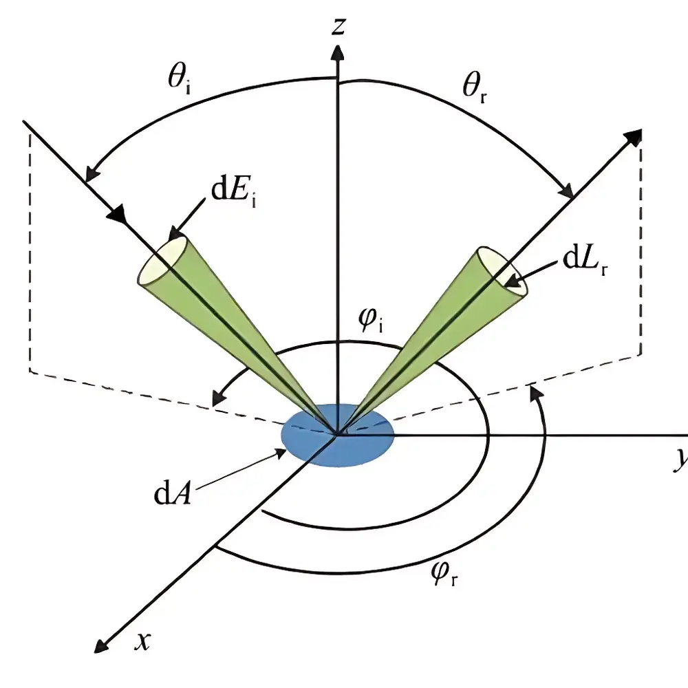
The AZUP A660B UAV-Based BRDF Measurement System is a purpose-built, integrated remote sensing platform engineered for high-fidelity bidirectional reflectance distribution function (BRDF) characterization of natural and managed surfaces. Unlike conventional multispectral or RGB drone surveys, the A660B implements a physically rigorous angular sampling strategy grounded in radiometric principles—specifically, simultaneous multi-angle, multi-azimuth spectral acquisition under controlled illumination geometry. The system leverages a synchronized gimbal-spectrometer-camera architecture mounted on a custom-designed hexacopter airframe, enabling autonomous execution of pre-programmed BRDF observation sequences that comply with ISO 19130-2 (Geographic information — Imagery sensor models and their parameters) and support traceable validation against ground-based reference measurements per ASTM E2758-22 (Standard Practice for Spectral Reflectance Factor Measurements Using Integrating Spheres). Its operational design targets ecological monitoring, vegetation phenotyping, soil surface anisotropy analysis, and calibration/validation of satellite-derived albedo products.
Key Features
- Proprietary AZUP Ground Control Station (GCS) software with embedded BRDF mission planner—enables one-click generation of georeferenced, solar-geometry-aware flight paths optimized for angular coverage density and shadow avoidance.
- Integrated BRDF observation module featuring motorized dual-axis gimbal (pitch/roll), capable of real-time attitude synchronization with UAV position and orientation data from onboard GNSS-INS.
- Carbon-fiber airframe (A660B platform) with 1550 mm wheelbase, dual 6S 25000 mAh high-voltage LiPo battery configuration, and redundant flight control architecture meeting DO-178C Level C functional safety requirements for non-critical avionics.
- Lightweight (<700 g) co-mounted payload assembly comprising a calibrated spectroradiometer (VIS-NIR, 350–1050 nm), a ≥20 MP global-shutter CMOS camera, and precision motion controller—all operating under shared time-stamped trigger signals from the flight controller.
- Fast-deploy gimbal interface with mechanical quick-release latches and standardized M3 mounting points, facilitating field-swappable payloads without recalibration.
- Angular resolution and repeatability: pitch/roll positioning accuracy ≤ ±0.02°; programmable slew rates up to 100°/s (pitch) and 30°/s (roll); full operational range: pitch +40° to −130°, roll ±45° (mechanical limits: pitch +45° to −135°, roll ±90°).
Sample Compatibility & Compliance
The A660B supports in situ BRDF sampling across heterogeneous terrestrial surfaces—including forest canopies, agricultural fields, grasslands, bare soils, snowpacks, and urban impervious materials—under natural solar illumination. Its angular sampling protocol aligns with the Committee on Earth Observation Satellites (CEOS) BRDF/Albedo Calibration and Validation Best Practices. All firmware, GCS software, and data logging modules are designed for GLP-compliant operation: metadata embedding (UTC timestamps, GPS coordinates, IMU quaternions, solar zenith/azimuth angles), encrypted local storage, and export-ready NetCDF-4/HDF5 file structures compliant with NASA’s LP DAAC and ESA’s Copernicus Data Space Ecosystem standards. The system meets electromagnetic compatibility (EMC) Class B requirements per EN 61000-6-3 and operates within FCC Part 15 Subpart C emission limits.
Software & Data Management
The AZUP GCS runs on Android 8.0+ devices and provides end-to-end mission lifecycle management—from pre-flight BRDF trajectory simulation using digital elevation models (DEMs) and solar ephemeris engines, to real-time telemetry overlay (attitude, battery voltage, spectral trigger status), to post-mission automated BRDF data stitching via geometric correction using onboard IMU and RTK-GNSS logs. Raw spectral radiance and digital number (DN) files are tagged with EXIF-compatible radiometric headers and stored with embedded calibration coefficients (wavelength calibration, dark current, flat-field response). Software supports batch export to common scientific formats (CSV, ENVI .hdr/.dat, HDF5) and includes built-in QA/QC flags for outlier detection based on signal-to-noise ratio (SNR) thresholds and gimbal angle validity checks. Audit trails, user authentication, and configurable data retention policies satisfy internal lab data integrity requirements aligned with ISO/IEC 17025:2017 Clause 7.5.2.
Applications
- Validation of BRDF kernels used in MODIS, Sentinel-3 OLCI, and Landsat Surface Reflectance products.
- Intra-seasonal monitoring of canopy structural anisotropy for crop health assessment and yield modeling.
- Quantification of snow grain size evolution and impurity-driven albedo feedback in cryospheric studies.
- Soil moisture and surface roughness retrieval via angular reflectance modeling (e.g., Ross-Thick-LiSparse kernel inversion).
- Development and testing of physics-based radiative transfer models (RTMs) such as 4SM, DISORT, and SAIL.
- Supporting field campaigns coordinated with NASA’s AERONET-OC, ESA’s Fiducial Reference Measurements (FRM4SOC), and CEOS Working Group on Calibration and Validation (WGCV) protocols.
FAQ
Does the A660B support real-time spectral data streaming to the ground station?
No—spectral acquisition is triggered synchronously with geoposition and attitude metadata at predefined waypoints; all raw data are stored onboard for post-mission download to ensure signal integrity and minimize RF interference.
Can the system be operated beyond visual line of sight (BVLOS)?
BVLOS operation requires national aviation authority approval (e.g., CAAC Part 92 in China, FAA Part 107 waiver in the U.S.) and integration with detect-and-avoid (DAA) systems not included in the base configuration.
Is the spectrometer factory-calibrated, and is NIST-traceable documentation provided?
Yes—each spectrometer module ships with a NIST-traceable calibration certificate (wavelength and irradiance) valid for 12 months, accompanied by a full uncertainty budget per ISO/IEC 17025 Annex A.
What level of GNSS positioning accuracy is achievable during BRDF missions?
With integrated RTK-GNSS and post-processed kinematic (PPK) correction, horizontal positional uncertainty is ≤2 cm RMS; vertical uncertainty is ≤3 cm RMS under open-sky conditions.
How is BRDF angular sampling density determined in the mission planner?
Sampling density is derived from user-defined constraints: minimum angular step (e.g., 5° in zenith, 15° in azimuth), maximum allowable solar zenith angle, and required overlap between adjacent view geometries to ensure kernel inversion stability.
Related Products


