DJI M600 Pro / M210 V2 / M300 RTK Integrated Hyperspectral Imaging System with MicaSense RedEdge-MX
| Brand | DJI |
|---|---|
| Origin | Shanghai, China |
| Manufacturer Type | Authorized Distributor |
| Regional Category | Domestic (PRC) |
| Model | RedEdge-MX Integrated UAV Platform |
| Pricing | Available Upon Request |
| Deployment | Airborne |
Overview
The DJI M600 Pro / M210 V2 / M300 RTK Integrated Hyperspectral Imaging System with MicaSense RedEdge-MX is a turnkey airborne remote sensing platform engineered for quantitative spectral analysis in field-based environmental and industrial monitoring. Unlike conventional RGB or multispectral systems, this solution leverages push-broom–compatible spectral acquisition via the RedEdge-MX sensor—a calibrated 5-band visible–near-infrared (VNIR) imager operating across discrete, narrowband spectral channels (475 nm, 560 nm, 668 nm, 717 nm, and 840 nm), each with <5 nm full-width-at-half-maximum (FWHM) bandwidth and radiometrically calibrated output in digital numbers (DN) traceable to NIST standards. The system operates on the principle of spatially registered spectral reflectance measurement: synchronized geotagged imagery is acquired during autonomous flight, enabling pixel-level calculation of vegetation indices (e.g., NDVI, NDRE, CIred-edge), chlorophyll content estimation, stress detection, and surface material classification. Designed for operational robustness in variable ambient conditions, it complies with ISO 17025-aligned calibration workflows and supports traceable data chains required for scientific publication and regulatory reporting.
Key Features
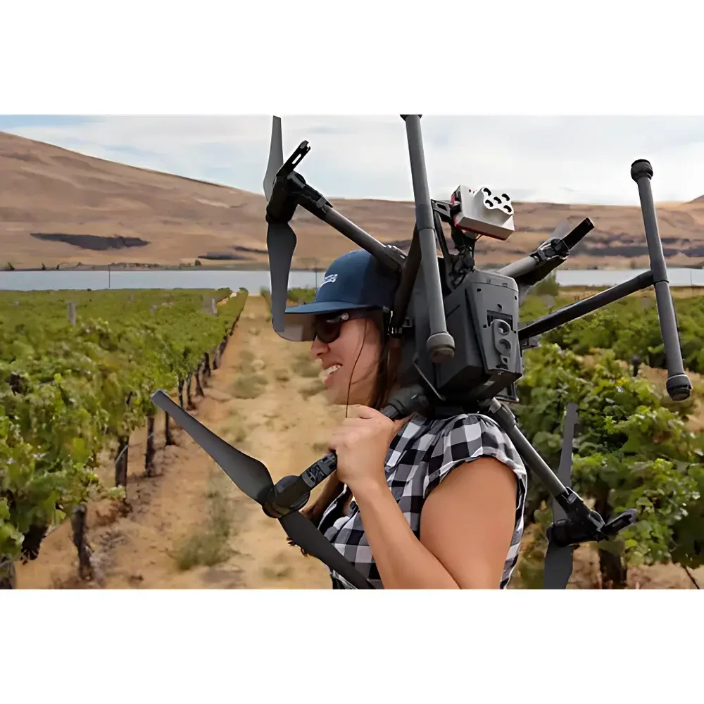
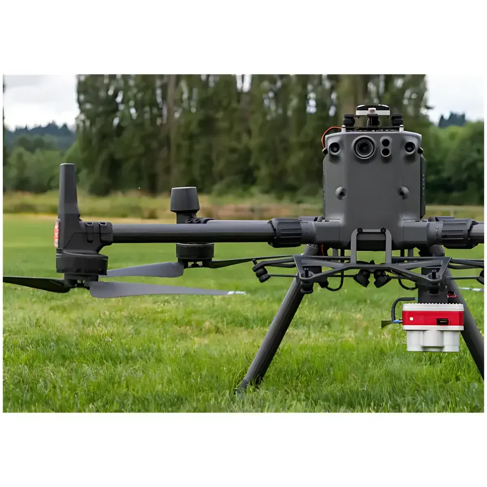
- Modular airborne integration compatible with DJI M600 Pro (6.0 kg payload capacity), M210 V2 (dual gimbal support, IP43 ingress protection), and M300 RTK (RTK/PPK GNSS positioning, 55-min max flight time, OcuSync Enterprise transmission)
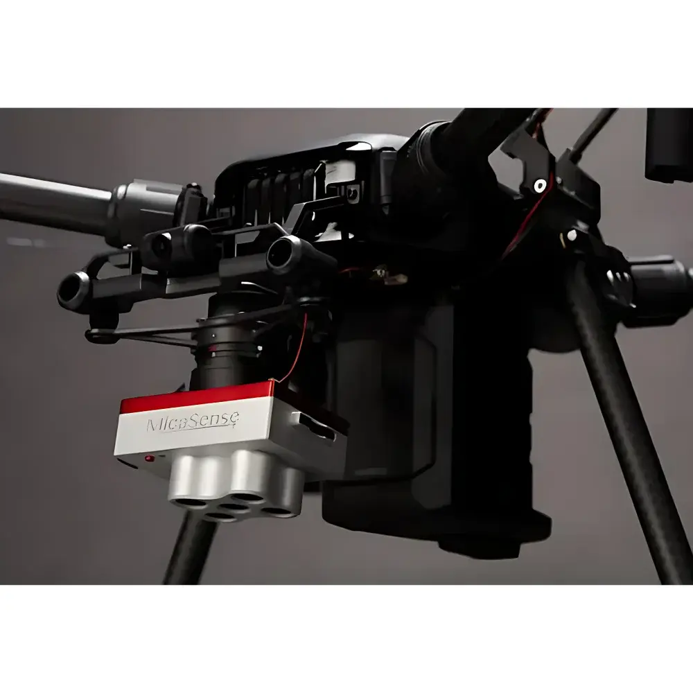
- MicaSense RedEdge-MX sensor with global shutter, onboard radiometric calibration, and integrated downwelling light sensor (DLS 2) for real-time illumination correction
- Hardware-synchronized triggering between flight controller and sensor, ensuring sub-millisecond timing accuracy and eliminating motion blur in high-speed surveys
- Triple-redundant A3 Pro flight controller (M600 Pro) and advanced IMU/GNSS fusion architecture (M300 RTK) for centimeter-level horizontal positioning accuracy (1 cm + 1 ppm RTK)
- Support for simultaneous multi-sensor payloads: co-mounted RedEdge-MX, FLIR thermal imaging modules (e.g., FLIR Vue Pro R), and 20 MP RGB cameras—enabling fused spectral-thermal-visual data acquisition in a single flight
- Compliance-ready architecture: firmware logs, sensor metadata embedding (EXIF/XMP), and encrypted telemetry storage align with GLP/GMP documentation requirements and FDA 21 CFR Part 11 audit-trail expectations
Sample Compatibility & Compliance
This system is not designed for laboratory benchtop analysis but for in situ, large-area spectral sampling of heterogeneous surfaces—including agricultural canopies, forest stands, solar farm arrays, utility infrastructure, and construction sites. It requires no sample preparation; instead, it captures reflectance spectra from natural or managed surfaces at altitudes ranging from 30 m to 120 m AGL, achieving ground sampling distances (GSD) between 1.2 cm and 4.8 cm depending on altitude and lens configuration. All RedEdge-MX data products conform to the FAO’s CropWatch protocol metadata schema and are interoperable with ENVI, QGIS, Agisoft Metashape, and Pix4Dmapper for orthomosaic generation and spectral index derivation. Calibration validation follows ASTM E2597–21 (Standard Practice for Calibration of Transmission Spectrophotometers) and ISO 18173:2017 (Remote sensing — Calibration of airborne imaging spectrometers).
Software & Data Management
Data acquisition is managed via DJI Pilot (M300 RTK) or DJI Assistant 2 (M600 Pro/M210 V2), with automated mission planning including grid, corridor, and waypoint modes. Raw RedEdge-MX imagery is processed using MicaSense Atlas cloud platform or local Agisoft Metashape workflows, generating radiometrically corrected GeoTIFFs with embedded coordinate reference systems (CRS), band-specific reflectance coefficients, and per-pixel uncertainty estimates. Atlas provides version-controlled project archives, user-access permissions, and export options compliant with ISO 19115 metadata standards. For regulated environments, optional on-premise deployment of Atlas Enterprise supports 21 CFR Part 11 electronic signature enforcement, audit log retention (>18 months), and role-based data governance policies.
Applications
- Agricultural precision management: nitrogen use efficiency mapping, irrigation scheduling, early disease detection (e.g., Fusarium head blight in wheat), and yield prediction modeling
- Forestry and ecology: species classification, canopy health assessment (via PRI, NDVI, and MCARI2), post-fire regeneration monitoring, and invasive species delineation
- Energy infrastructure: photovoltaic panel soiling quantification, thermal anomaly detection in transmission lines, and wind turbine blade defect identification
- Civil engineering: asphalt composition analysis, subsurface moisture mapping in embankments, and structural deformation tracking via multi-temporal spectral change detection
- Environmental compliance: wetland boundary verification, sediment plume tracking in coastal zones, and landfill leachate seepage detection
FAQ
Is the RedEdge-MX sensor factory-calibrated and does it support field recalibration?
Yes—the RedEdge-MX undergoes factory radiometric calibration against NIST-traceable standards and includes an onboard DLS 2 for real-time illumination normalization. Field recalibration is supported via MicaSense’s CalPanel workflow using certified reflectance targets.
What GNSS accuracy can be achieved with the M300 RTK in standalone versus RTK/PPK mode?
Standalone GPS yields ~1.5 m CEP; with D-RTK 2 base station, horizontal accuracy improves to 1 cm + 1 ppm RMS; PPK post-processing achieves sub-centimeter repeatability without real-time base station dependency.
Does the system meet ISO/IEC 17025 requirements for field-deployed analytical instrumentation?
While ISO/IEC 17025 applies primarily to accredited laboratories, the platform’s documented calibration chain, raw data integrity controls, and metadata completeness enable users to establish metrological traceability per ISO/IEC 17025 Clause 5.5.2 for field measurement systems.
Can raw hyperspectral data be exported in ENVI-compatible format for custom spectral unmixing algorithms?
Yes—Radiometrically corrected, georeferenced band stacks are exported as BIL/BIP-interleaved ENVI .hdr/.bin files with full wavelength and FWHM definitions embedded in header metadata.
What is the maximum concurrent sensor configuration supported on the M300 RTK?
The M300 RTK supports up to three payloads simultaneously via dual gimbals and auxiliary mounting points: e.g., RedEdge-MX (primary gimbal), FLIR Tau2 thermal camera (secondary gimbal), and Zenmuse L1 LiDAR (auxiliary mount), all synchronized via DJI Payload SDK v4.2.