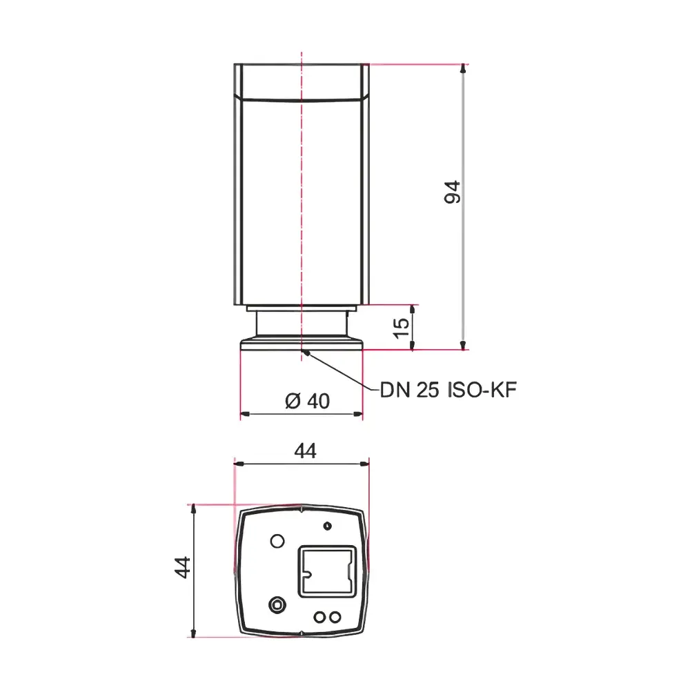
Auniontech 1 pT High-Precision Optical Pump Magnetometer
| Brand | Auniontech |
|---|---|
| Origin | Imported |
| Model | 1 pT |
| Sensitivity | 1 pT/√Hz |
| Measurement Range | 20–100 µT |
| Typical Drift | <0.3 nT |
| Sampling Rate | 1000 Hz |
| Closed-Loop Bandwidth | 30 Hz |
| Sensor Angular Acceptance | ±45° |
| Operating Temperature | −20 °C to +40 °C |
Overview
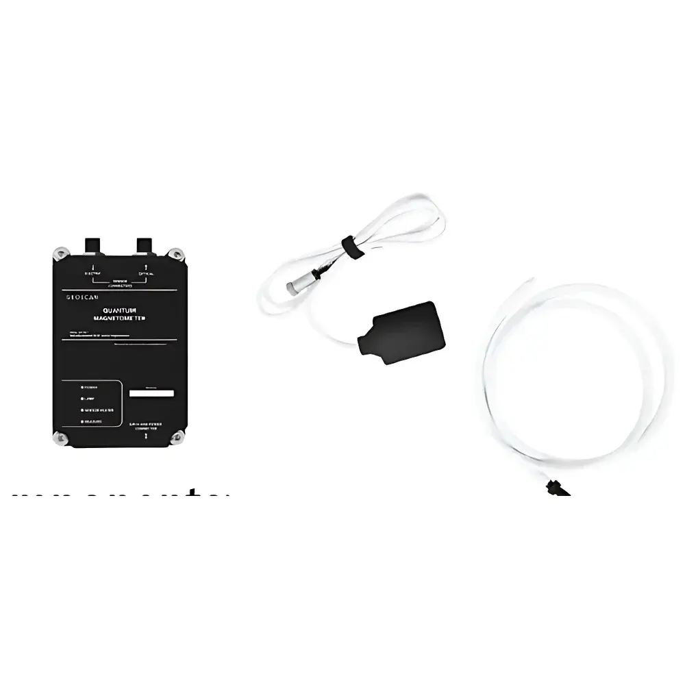
The Auniontech 1 pT High-Precision Optical Pump Magnetometer is a quantum-based scalar magnetometer engineered for absolute measurement of total magnetic field intensity with sub-picotesla resolution. It operates on the principle of optical pumping and electron paramagnetic resonance (EPR) in rubidium-87 vapor cells. In the presence of an external magnetic field, the hyperfine energy levels of rubidium atoms undergo Zeeman splitting—the magnitude of which is linearly proportional to the local magnetic flux density. Circularly polarized pump light aligns atomic magnetic moments; subsequently, a radiofrequency (RF) field induces resonant transitions between Zeeman sublevels. The resonant frequency—directly tied to the Larmor precession frequency—is measured with high spectral accuracy, enabling traceable, drift-free determination of the total field magnitude (|B|) in SI units (tesla). Unlike proton precession or fluxgate magnetometers, this instrument delivers true scalar output without orientation dependence, zero-point drift, or temperature-induced calibration shifts—making it suitable for dynamic, unattended, and motion-tolerant deployments in geophysical surveying, airborne platforms, and laboratory metrology.
Key Features
- Quantum-limited sensitivity of 1 pT/√Hz—enabling detection of ultra-weak field anomalies associated with buried ferrous structures, geological discontinuities, or biomagnetic signals.
- True scalar measurement: outputs absolute |B| value independent of sensor attitude—eliminates need for precise leveling or gimbal stabilization during UAV-borne or vehicle-mounted surveys.
- High temporal resolution: 1 kHz sampling rate with 30 Hz closed-loop bandwidth supports rapid spatial mapping and transient field monitoring (e.g., magnetic pulsations, EM induction responses).
- Wide dynamic range: 20–100 µT coverage accommodates both near-surface terrestrial fields (~50 µT) and controlled laboratory environments with magnetic shielding.
- Robust thermal design: operational stability maintained across −20 °C to +40 °C ambient conditions—validated for extended field campaigns in alpine, maritime, and desert environments.
- No intrinsic magnetic signature: non-ferromagnetic construction ensures minimal self-field interference—critical for low-noise drone-integrated magnetometry.
Sample Compatibility & Compliance
This magnetometer is designed for direct measurement of ambient DC and quasi-static magnetic fields in air, water, or soil interface environments. It does not require physical contact with samples and is insensitive to non-magnetic media properties (e.g., conductivity, permittivity, or salinity). The system complies with IEC 61000-4-3 (radiated immunity) and meets mechanical shock/vibration requirements per MIL-STD-810G for airborne deployment. While not certified under FDA 21 CFR Part 11 or ISO 17025, its traceable calibration methodology follows ASTM D7541-21 (Standard Practice for Magnetic Field Measurement in Geophysical Surveys) and supports GLP-aligned data acquisition workflows when integrated with timestamped GPS and inertial navigation systems.
Software & Data Management
The instrument interfaces via USB-C or RS-422 serial protocol and is fully supported by Auniontech’s GeoMag Suite—a cross-platform application enabling real-time field visualization, automatic baseline correction, and noise spectral analysis. Raw time-series data are logged in IEEE 754-compliant binary format with embedded UTC timestamps, sensor temperature, and RF lock status flags. Post-processing tools include vertical gradient computation (dZ/dz), terrain-corrected anomaly extraction (using digital elevation models), and gridding via minimum-curvature interpolation onto georeferenced UTM grids. Export options include GeoTIFF (with embedded projection metadata), ASCII XYZ, and SEG-Y-compatible formats for integration with industry-standard geophysical interpretation packages (e.g., Oasis montaj, Geosoft VOXI). Audit trails, user-defined calibration offsets, and firmware version logging support regulatory documentation requirements for environmental site assessments.
Applications
- Airborne magnetic surveying: UAV-mounted operation at altitudes ≤30 m AGL enables high-resolution detection of shallow mineralization, UXO, and archaeological features with <1 m lateral resolution.
- Seismomagnetic precursor studies: continuous long-term monitoring of crustal field variations correlated with tectonic stress accumulation.
- Oceanic magnetic anomaly mapping: towed-array deployment for marine magnetic line surveys supporting plate tectonic modeling and hydrocarbon exploration.
- Lab-based fundamental physics experiments: characterization of magnetic shielding performance, testing of mu-metal enclosures, and validation of magnetic compensation coils.
- Biomedical research infrastructure: reference-grade field monitoring in magnetoencephalography (MEG) shielded rooms and low-field MRI development labs.
FAQ
Does this magnetometer measure vector components (Bx, By, Bz) or only total field magnitude?
It measures only the scalar total field intensity (|B|). Vector decomposition requires orthogonal triaxial fluxgate or SQUID systems. However, vertical gradients can be derived using dual-sensor configurations.
Is factory calibration traceable to national standards?
Yes—each unit is calibrated against a NIST-traceable Helmholtz coil system at three field points (30, 50, and 70 µT) with uncertainty <0.15 nT (k=2). Calibration certificates include temperature-dependent correction coefficients.
Can it operate autonomously onboard an unmanned aerial vehicle without GNSS integration?
Yes—the core magnetometer functions independently. However, georeferencing of measurements requires synchronized GNSS position and attitude data, typically provided by an external INS/GNSS unit via UART or PPS synchronization.
What is the recommended warm-up time before achieving specified sensitivity?
Full thermal and atomic polarization stabilization is achieved within 15 minutes after power-on at 25 °C ambient. Performance specifications assume ≥20 min stabilization.
Are software updates and firmware patches available post-purchase?
Yes—registered users receive free access to firmware updates and GeoMag Suite releases for five years from date of shipment, including enhancements to noise filtering algorithms and export compatibility.