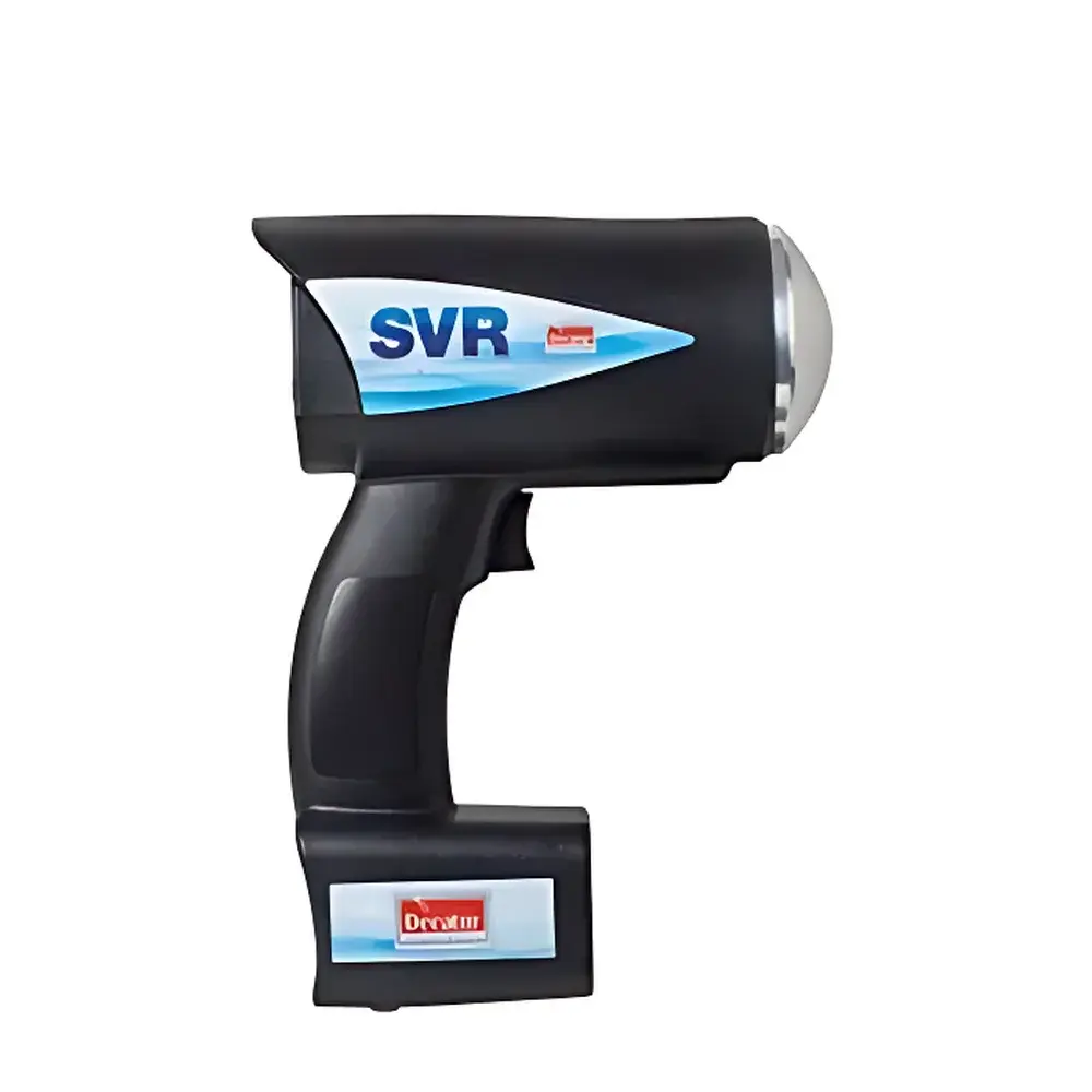
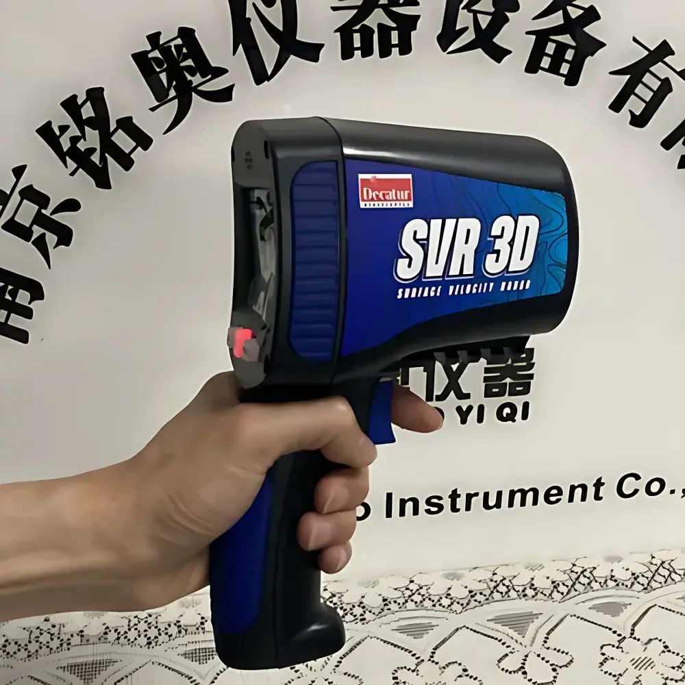
Decatur SVR 3D Portable Radar Velocity Meter
| Brand | Decatur |
|---|---|
| Origin | USA |
| Manufacturer Type | Authorized Distributor |
| Product Origin | Imported |
| Model | SVR |
| Liquid Mass Flow Accuracy | ±1% |
| Velocity Range | 0.30–20.00 m/s |
| Velocity Accuracy | ±0.05 m/s |
| Resolution | 0.01 m/s |
| Maximum Measurement Distance | 100 m |
| Radar Beam Angle | 12° |
| Transmit Power | 7 mW |
| Operating Frequency | 24.150 GHz |
| Operating Temperature | −30 °C to +70 °C |
| Ingress Protection Rating | IP55 (per IEC 60529:1989 / EN 60529) |
| Power Supply | +8.5 VDC to +16.5 VDC |
| Dimensions | 26.3 cm × 7.62 cm × 18.4 cm |
| Weight | 1.3 kg (including NiMH battery pack) |
| Battery Life | Up to 8 hours continuous operation |
| Built-in Tilt Sensor | Automatic vertical angle compensation |
| Horizontal Angle Input | Manual entry with cosine correction |
| Flow Direction Detection | Automatic sensing |
| Sensitivity Adjustment | 10-level user-selectable |
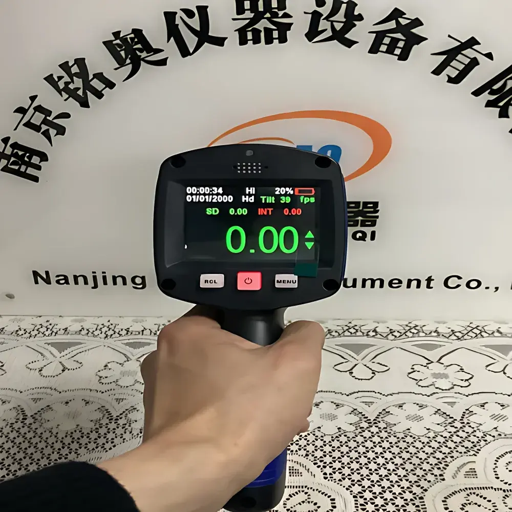
| Display | Backlit LCD |
| Data Storage | 50 measurement records with recall function |
Overview
The Decatur SVR 3D Portable Radar Velocity Meter is a field-deployable, non-contact surface velocity measurement instrument engineered for rapid, reliable hydrometric assessment in dynamic and hazardous open-channel environments. It operates on the principle of continuous-wave Doppler radar at 24.150 GHz — a frequency band selected for its minimal atmospheric attenuation under rain, fog, or high-humidity conditions. Unlike acoustic or electromagnetic flow sensors requiring immersion or channel instrumentation, the SVR measures instantaneous water surface velocity by detecting the Doppler shift of reflected microwave energy from moving water particles. This surface velocity is then converted to mean cross-sectional velocity using empirically validated surface velocity coefficients (e.g., ISO 748, ASTM D3858), enabling real-time discharge estimation when paired with surveyed channel geometry. The instrument is purpose-built for emergency hydrological response — including flood peak capture, breach monitoring, debris flow characterization, and post-storm reconnaissance — where speed, operator safety, and environmental resilience are critical.
Key Features
- Ultra-portable design weighing only 1.3 kg (including integrated NiMH battery pack), optimized for single-operator deployment in remote or inaccessible terrain.
- True handheld operation supported by optional tripod mounting; ergonomic housing with tactile controls for gloved-hand use.
- Integrated tilt sensor enables automatic vertical angle compensation — eliminating manual elevation correction and reducing measurement uncertainty associated with operator positioning.
- Manual horizontal angle input triggers real-time cosine correction, ensuring accurate velocity projection along the channel’s flow vector.
- Automatic flow direction detection provides unambiguous upstream/downstream identification without reorientation.
- IP55-rated enclosure conforms to IEC 60529 and EN 60529 standards, delivering protection against dust ingress and low-pressure water jets — suitable for sustained outdoor use during rainfall events.
- 10-step sensitivity adjustment allows optimization across varying surface conditions: smooth laminar flow, turbulent aerated water, or sediment-laden surges.
- Backlit LCD display delivers clear real-time readouts: instantaneous velocity, 60-second averaged velocity, measurement distance, tilt angle, and signal strength indicator.
- Onboard memory stores up to 50 complete measurement records, each timestamped and retrievable via intuitive menu navigation.
Sample Compatibility & Compliance
The SVR 3D is designed exclusively for open-channel surface velocity measurement in natural and engineered waterways — rivers, canals, spillways, culverts, and overland flow paths. It requires no physical contact with water, rendering it insensitive to suspended solids, floating debris, oil films, or biological growth — factors that commonly impair ultrasonic or electromagnetic sensors. Its 24.150 GHz radar beam exhibits negligible refraction in mist or light precipitation, maintaining consistent performance during active storm events. The instrument complies with international electromagnetic compatibility (EMC) directives and meets FCC Part 15 Class B emission limits. While not a primary discharge meter per se, its velocity output supports compliance with ISO 748:2010 (Measurement of liquid flow in open channels — Velocity-area method) and ASTM D3858-22 (Standard Practice for Determining Discharge of Open Channels Using Surface Velocity Measurements) when used within defined operational envelopes and calibrated surface velocity coefficients.
Software & Data Management
The SVR 3D operates as a self-contained field instrument with no external software dependency. All data acquisition, processing, and storage occur onboard. Measurement records include date/time stamp, raw Doppler frequency, computed velocity (instantaneous and 60-s average), tilt angle, horizontal angle, signal quality index, and battery voltage. Data recall is accessible directly through the device interface; export functionality is not provided — aligning with its role as a rapid-response verification tool rather than a long-term telemetry platform. For integration into broader hydrological workflows, users may manually transcribe values into spreadsheet-based discharge calculators or GIS-enabled field applications. Firmware updates (if released) are performed via standard USB-to-serial adapter and vendor-provided utility — documentation adheres to IEC 62304 software lifecycle requirements for Class B medical-device-equivalent embedded systems.
Applications
- Flood emergency response: Real-time peak flow tracking during rising limb, crest, and recession phases — especially where traditional gauging infrastructure is compromised or absent.
- Dam breach and levee failure assessment: Rapid quantification of outflow velocity to inform evacuation modeling and downstream impact analysis.
- Sediment transport studies: Surface velocity profiling across varying grain-size distributions and turbidity regimes without sensor fouling.
- Urban stormwater management: Verification of flow velocities in drainage channels, detention basins, and combined sewer overflows (CSOs).
- Post-wildfire runoff monitoring: Measurement in ash-laden, highly erosive flows where submerged sensors risk clogging or damage.
- Regulatory compliance verification: Supporting USGS, EPA, or state agency field audits requiring traceable, operator-independent velocity data.
FAQ
Does the SVR 3D require calibration against a reference standard?
Yes. While factory-calibrated prior to shipment, periodic verification against a certified current meter or known-velocity flume is recommended per ISO/IEC 17025 guidelines — particularly after mechanical shock or extended exposure to extreme temperatures.
Can the SVR 3D measure velocity in tidal or reversing flows?
Yes. Its automatic flow direction detection distinguishes upstream vs. downstream motion, enabling bidirectional velocity capture in estuarine or regulated canal environments.
Is the 24.150 GHz radar safe for prolonged operator exposure?
Yes. With a maximum transmit power of 7 mW and narrow 12° beam divergence, the SVR 3D operates well below ICNIRP and IEEE C95.1 occupational exposure limits — no special PPE or training is required.
What is the minimum detectable water surface velocity?
The instrument reliably resolves velocities ≥0.30 m/s under typical field conditions. Performance below this threshold depends on surface roughness, beam incidence angle, and ambient RF noise.
How does the SVR 3D handle multipath interference from nearby banks or vegetation?
Its directional antenna design and narrow beamwidth minimize off-axis reflections. Users are advised to maintain a clear line-of-sight path and avoid aiming near steep, reflective banks within the 12° beam envelope.