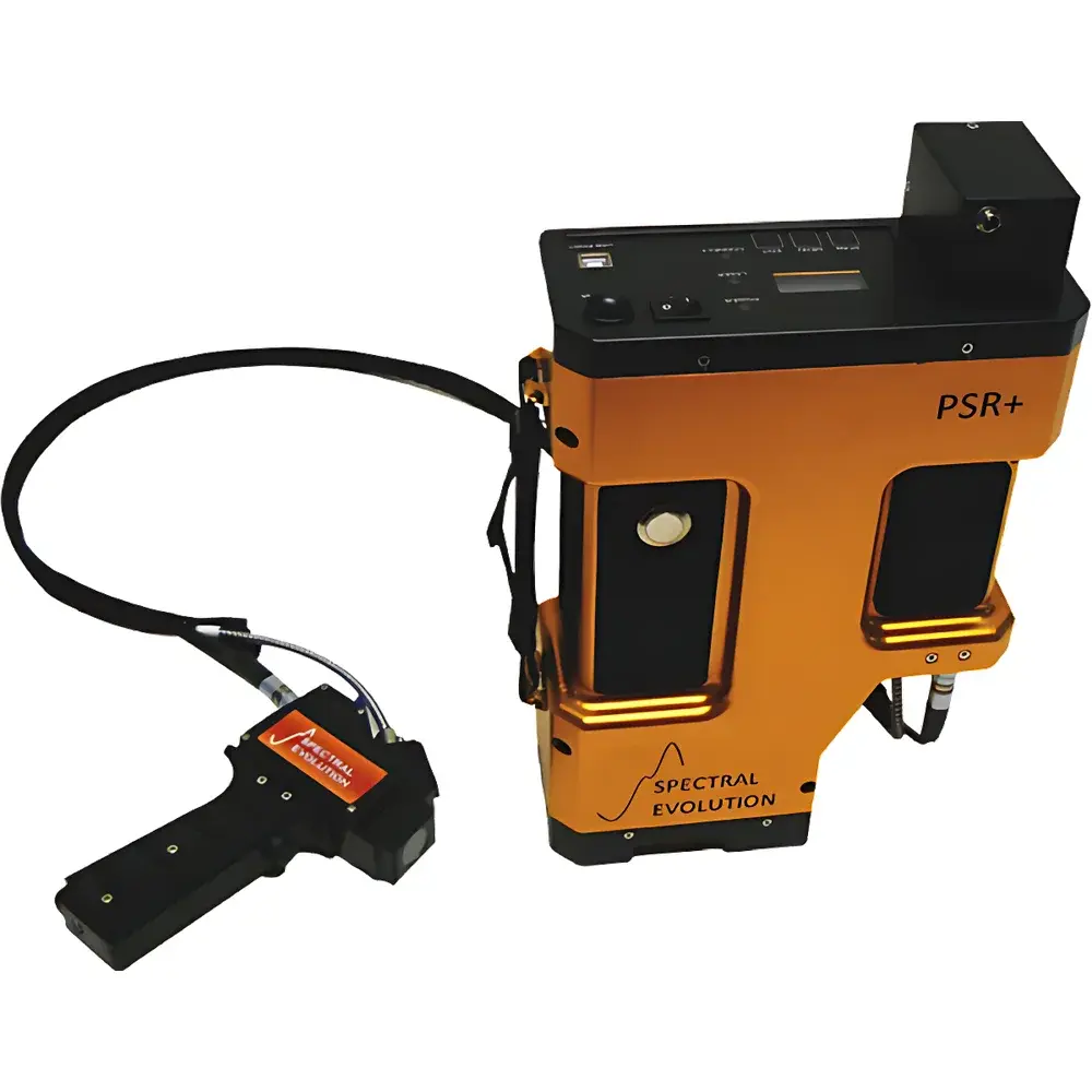
A660-SEI Airborne Ground Object Spectral Measurement System
| Brand | SEI |
|---|---|
| Origin | USA |
| Model | A660-SEI |
| Spectral Range | 350–2500 nm |
| Spectral Resolution | 2.8 nm @ 700 nm |
| Imaging Mode | 3D |
| Platform Compatibility | Ground-based and airborne operation |
| Detector Configuration | 512-pixel Si array (350–1000 nm), 256-pixel TE-cooled extended InGaAs arrays (970–1910 nm and 1900–2500 nm) |
| Spectral Channels | 2151 (1-nm output interval) |
| NEDL | ≤0.5×10⁻⁹ W/cm²/nm/sr @ 400 nm |
| Measurement Speed | 100 ms |
| Wavelength Accuracy | ±0.5 nm (FWHM) |
| Wavelength Repeatability | 0.1 nm |
| Max Radiance | 1.5×10⁻⁴ W/cm²/nm/sr @ 700 nm (4° fore-optic) |
| System Weight | 3.3 kg |
| Integrated GPS | PDA-mounted, geotagged spectral storage (up to 100,000 spectra) |
| Operating Modes | Standalone, tablet/PDA-controlled, UAV-synchronized autonomous acquisition |
Overview
The A660-SEI Airborne Ground Object Spectral Measurement System is a rigorously engineered hyperspectral remote sensing platform integrating Spectral Evolution Inc.’s (SEI) field-proven full-range spectroradiometers with the AZUP A660 long-endurance multirotor UAV. Designed for quantitative reflectance and radiance measurements across the ultraviolet–visible–near-infrared–shortwave infrared (UV–VIS–NIR–SWIR) spectrum (350–2500 nm), the system operates on the principle of push-broom and snapshot spectral imaging—leveraging fixed-grating dispersion and thermoelectrically cooled InGaAs and silicon detector arrays to deliver high-fidelity, laboratory-grade spectral data in dynamic airborne and ground-based deployments. Its architecture supports traceable calibration workflows compliant with ASTM E275, ISO 17025, and NASA’s CEOS/Cal/Val protocols, making it suitable for satellite vicarious calibration, atmospheric correction validation, and biophysical parameter retrieval under real-world environmental conditions.
Key Features
- Triple-detector optical path: 512-pixel Si CCD (350–1000 nm), dual 256-pixel TE-cooled extended InGaAs arrays (970–1910 nm and 1900–2500 nm) ensure continuous spectral coverage without mechanical scanning or gap interpolation.
- Field-reconfigurable fore-optics: Interchangeable lenses (e.g., 4°, 8°, 25° FOV) and fiber-coupled configurations enable rapid adaptation to varying spatial sampling requirements—from plot-scale vegetation analysis to regional mineral mapping.
- Hardware-synchronized acquisition: GPS-triggered spectral capture ensures strict temporal alignment between geolocation metadata, nadir imagery, and radiometric data—critical for orthorectification and pixel-level spectral unmixing.
- Thermally stabilized aluminum chassis: Passive heat dissipation maintains detector temperature stability within ±0.3°C over ambient ranges of −10°C to +45°C, minimizing dark current drift and wavelength shift.
- Embedded PDA interface: Android-based touchscreen unit with integrated GPS provides real-time spectral preview, auto-exposure optimization, and onboard spectral library management—no external laptop required for field operation.
- UAV-integrated stabilization: Precision gimbal system decouples spectral sensor motion from aircraft dynamics, achieving <0.05° pointing stability at flight speeds up to 12 m/s and altitudes of 30–500 m AGL.
Sample Compatibility & Compliance
The A660-SEI system is validated for non-contact, non-destructive measurement of heterogeneous natural and anthropogenic surfaces—including vegetative canopies, soil profiles, aquatic sediments, rock outcrops, and urban materials—without requiring physical sampling or surface preparation. Its radiometric accuracy is maintained per NIST-traceable calibration standards (using calibrated halogen and quartz-tungsten-halogen sources), with annual recalibration recommended per ISO/IEC 17025:2017 Clause 7.7. The system complies with FAA Part 107 operational requirements for small UAS in the United States and meets CE marking directives for electromagnetic compatibility (EN 61000-6-3) and safety (EN 61010-1). Data provenance adheres to FAIR principles (Findable, Accessible, Interoperable, Reusable), supporting integration into ESA’s Copernicus Ground Segment and USGS Earth Explorer workflows.
Software & Data Management
Data acquisition and post-processing are supported by SEI’s SpectraWiz v6.x software suite, which provides automated dark/reference correction, BRDF normalization, atmospheric correction (via MODTRAN5 integration), and ENVI-compatible BIL/BIP export. All spectral files conform to the Hierarchical Data Format (HDF5) standard with embedded metadata per the PDS4 Spectral Data Node schema. Audit trails—including operator ID, GPS timestamp, instrument temperature, integration time, and calibration certificate ID—are recorded in accordance with FDA 21 CFR Part 11 and GLP-compliant electronic lab notebook (ELN) frameworks. Raw and processed datasets are exportable in ASCII, CSV, and GeoTIFF formats for GIS interoperability (ArcGIS Pro, QGIS 3.30+).
Applications
- Satellite sensor vicarious calibration and cross-sensor validation (e.g., Landsat 9 OLI-2, Sentinel-2 MSI, PRISMA)
- High-resolution crop phenotyping: chlorophyll content, water stress index (NDWI), nitrogen use efficiency (NUE) mapping
- Soil organic carbon and clay mineral identification via SWIR absorption feature analysis (2200 nm Al–OH, 2300 nm Mg–OH)
- Coastal and inland water quality monitoring: CDOM, suspended particulate matter, phytoplankton pigment estimation
- Geological mapping: discrimination of kaolinite, montmorillonite, goethite, and hematite using diagnostic absorption minima
- Environmental change detection: post-wildfire burn severity assessment, mine tailings characterization, landfill leachate plume tracking
FAQ
Is the A660-SEI system compatible with third-party UAV platforms beyond the AZUP A660?
Yes—mechanical and electrical interfaces follow MAVLink 2.0 and STANAG 4609-compliant mounting standards; custom integration kits (including CAN bus and UART trigger modules) are available upon request.
What calibration certificates accompany the system upon delivery?
Each unit ships with NIST-traceable radiometric calibration report (covering 350–2500 nm), spectral linearity verification, and geometric FOV characterization—valid for 12 months from date of issue.
Can spectral data be acquired under variable illumination conditions (e.g., partial cloud cover)?
Yes—the system’s auto-exposure algorithm dynamically adjusts integration time (1–1000 ms range) while maintaining SNR > 500:1 across all bands; concurrent irradiance monitoring via optional cosine-corrected reference sensor enables post-hoc solar zenith angle correction.
Does the system support real-time spectral classification during flight?
Real-time onboard processing is limited to radiometric normalization and GPS-tagged spectral indexing; full spectral classification (e.g., SVM, Random Forest) requires post-flight analysis using ENVI or Python-based scikit-learn pipelines.
How is data security handled during wireless telemetry transmission?
All RF links (2.4 GHz and 5.8 GHz) employ AES-128 encryption; raw spectral files remain stored exclusively on the PDA’s encrypted microSD card until manual transfer—no cloud upload occurs without explicit user authorization.
Related Products