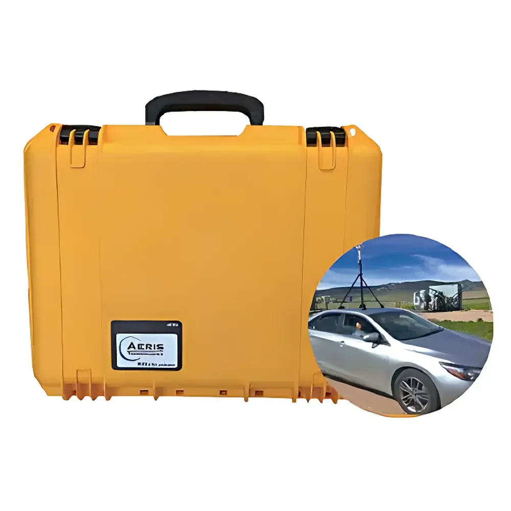
Aeris Responder Advanced Mobile LDS
| Origin | USA |
|---|---|
| Manufacturer Type | Authorized Distributor |
| Origin Category | Imported |
| Model | Responder Advanced Mobile LDS |
| Price | Upon Request |
Overview
The Aeris Responder Advanced Mobile LDS is a field-deployable, real-time methane (CH4) and ethane (C2H6) detection system engineered for high-fidelity natural gas leak identification, quantification, and geospatial mapping. Unlike conventional near-infrared (NIR) or catalytic bead-based mobile sensors, the Responder leverages Aeris’ proprietary mid-infrared (MIR) folded-path laser absorption spectroscopy — a physics-based measurement principle offering >1,000× stronger molecular absorption cross-sections than NIR for hydrocarbons. This enables sub-ppb/s sensitivity to CH4 and sub-500-ppt/s sensitivity to C2H6, critical for distinguishing thermogenic natural gas (C2H6/CH4 ≈ 1–10%) from biogenic sources (e.g., landfills, agriculture), which typically exhibit C2H6/CH4 ratios <0.01%. The system operates on the fundamental premise that ethane serves as a robust chemical tracer for fossil-derived methane; its presence at quantifiable levels above background noise confirms pipeline or wellhead leakage rather than ambient or microbial emissions.
Key Features
- Mid-infrared laser absorption spectroscopy with folded optical path (>13 m effective pathlength in a 60 mL multi-pass cell)
- Real-time dual-gas detection: CH4 (<1 ppb/s) and C2H6 (<500 ppt/s) at 1–2 Hz sampling rate
- Integrated GPS (1 m horizontal accuracy) and ultrasonic anemometry for wind-aware plume attribution
- Modular architecture: sensor head (2.75 kg, 11.5″ × 8″ × 3.75″) mounts magnetically or via vehicle bracket; full system installation completed in <5 minutes without vehicle modification
- Field-reconfigurable operation: same sensor functions as both vehicle-mounted mobile mapper and handheld ground survey instrument
- Low-power design: 15–40 W nominal consumption; supports onboard 6-hour battery backup and direct 12–15 V DC or 110–220 V AC input
- Cloud-enabled data streaming via cellular/WiFi; local storage up to 2 TB SSD + unlimited cloud archive
Sample Compatibility & Compliance
The Responder Advanced Mobile LDS is validated for continuous ambient air sampling under operational conditions of 10–40 °C and 10–95% RH (non-condensing). Its MIR optical core contains no delicate high-reflectivity mirrors — instead relying on a monolithic, hermetically sealed optical bench with integrated laser diode and photodetector — conferring immunity to vibration, particulate fouling, and thermal drift. While not certified to ISO/IEC 17025 for accredited laboratory testing, the system meets functional performance criteria aligned with EPA Method 21 (leak detection), ASTM D6522 (ambient hydrocarbon analysis), and OGMP 2.0 Tier 2 reporting requirements. Data provenance supports GLP-compliant workflows through timestamped, GPS-georeferenced records with audit-trail metadata (sensor status, calibration epoch, environmental parameters).
Software & Data Management
The Responder software suite provides two operational modes: live mapping and post-processing analysis. In live mode, operators view a dynamic GIS overlay showing real-time CH4/C2H6 concentration contours, wind vector-adjusted plume direction, and auto-generated leak markers tagged with priority scores based on user-defined thresholds (e.g., C2H6/CH4 ratio, absolute flux estimate, proximity to infrastructure). Driver-facing displays are intentionally restricted to route visualization only — sensitive leak data is accessible only to authorized analysts. All raw spectra, concentration time-series, and positional metadata are stored in HDF5 format with embedded calibration coefficients. Cloud integration supports automated ingestion into enterprise asset management platforms (e.g., Esri ArcGIS, Palantir Foundry) and enables remote calibration validation, firmware updates, and collaborative annotation across distributed teams.
Applications
- Utility distribution system integrity verification (mains, service lines, regulator stations)
- Urban leak prioritization for repair scheduling under regulatory mandates (e.g., NY PSC, CA AB 1625)
- Landfill gas vs. pipeline leak discrimination in mixed-emission zones
- Pre- and post-mitigation verification surveys for LDAR programs
- Mobile baseline monitoring along transmission corridors and compressor stations
- Academic and regulatory research on fugitive emission inventories and atmospheric transport modeling
FAQ
How does the Responder distinguish natural gas leaks from biogenic methane sources?
It quantifies the ethane-to-methane ratio (C2H6/CH4) in real time. Thermogenic natural gas contains measurable ethane (typically 0.5–10% by volume); landfill gas and enteric fermentation emit nearly pure methane (0.01 strongly indicates fossil origin.
What is the minimum detectable leak rate the system can resolve?
Detection limit depends on wind speed, sensor height, and plume dispersion. Under typical urban driving conditions (15 km/h, 1.5 m AGL), the system reliably identifies leaks ≥0.5 g CH4/hr at distances ≤10 m from the source.
Is the system compatible with existing GIS infrastructure?
Yes — all output conforms to OGC-compliant GeoJSON and GPX standards; APIs support direct integration with Esri, QGIS, and custom web-mapping dashboards.
Does the Responder require routine calibration in the field?
No zero/span calibration is needed during operation. Factory calibration remains stable for ≥12 months; optional annual traceable recalibration is available using NIST-traceable gas standards.
Can the sensor be used for stationary monitoring?
Yes — the compact sensor module supports tripod mounting and external power for fixed-site fence-line monitoring, with identical sensitivity and data output protocols.


