AERO AZCW Hybrid VTOL UAV System
| Brand | AERO |
|---|---|
| Origin | Beijing, China |
| Manufacturer Type | Authorized Distributor |
| Country of Origin | Domestic (China) |
| Model | AZCW |
| Price Range | USD 70,000 – 345,000 |
Overview
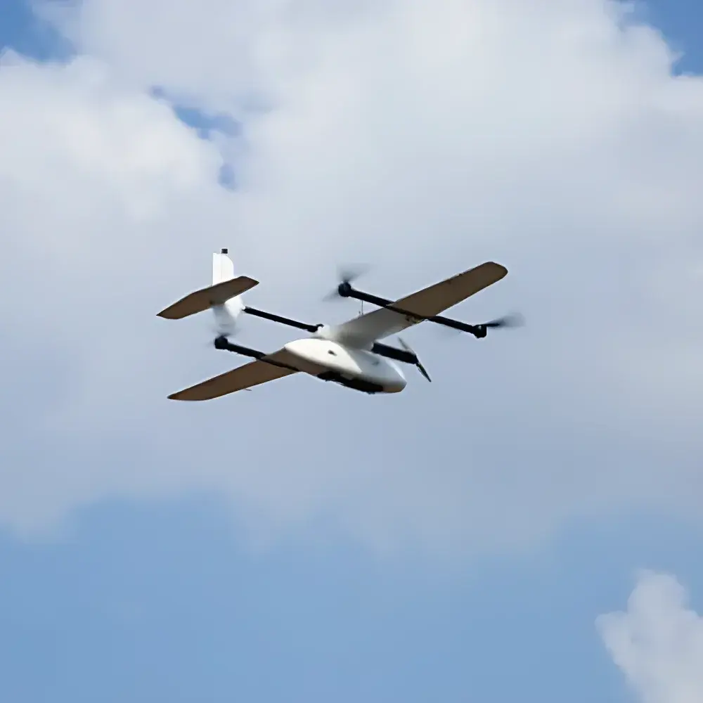
The AERO AZCW Hybrid VTOL UAV System is an engineered solution for high-efficiency, mission-critical environmental remote sensing and telemetry operations. Designed around a fixed-wing + quadrotor compound-wing architecture, the AZCW bridges the operational gap between conventional fixed-wing platforms—known for extended endurance, high cruise speed, and large-area coverage—and multirotor systems—valued for vertical takeoff and landing (VTOL), hover capability, and low-speed maneuverability. Its aerodynamic configuration is validated through wind tunnel testing, and flight control relies on total energy adaptive algorithms to maintain stable attitude across varying atmospheric conditions and payload configurations. The system operates under fully autonomous flight logic, executing pre-programmed missions—including transition between VTOL and forward flight modes—without real-time pilot input. This architecture enables reliable deployment in ecologically sensitive, topographically constrained, or infrastructure-limited environments where traditional UAVs face logistical or safety constraints.
Key Features
- Hybrid VTOL Architecture: Combines fixed-wing efficiency (up to 120 min endurance, >80 km/h cruise speed) with quadrotor VTOL capability for zero-runway operation.
- Full-Autonomy Flight Stack: Industrial-grade flight controller with dual-redundant inertial measurement units (IMUs), integrated RTK/PPK GNSS receiver, and fail-safe transition logic for seamless mode switching.
- Centimeter-Level Positioning: Dual-mode GNSS support—real-time kinematic (RTK) for sub-10 cm vertical landing accuracy and post-processed kinematic (PPK) for georeferenced POS data with ≤2 cm horizontal/vertical uncertainty.
- High-Precision Imaging Integration: Synchronized exposure module with <10 ms shutter delay; compatible with frame-based RGB, multispectral, thermal, and hyperspectral payloads (e.g., MicaSense Altum, FLIR Tau2, Headwall Nano-Hyperspec).
- Modular Payload Interface: Tool-free quick-release mechanism using standardized aviation-grade pins, latches, and self-locking connectors—enabling rapid sensor swaps in <90 seconds.
- Redundant Navigation Architecture: Dual independent GPS modules with automatic failover; dual magnetometer system (internal + external gimbal-mounted) for robust heading estimation in magnetic disturbance zones.
- Regulatory-Ready Design: Compliant with ICAO Annex 2 (Rules of the Air) and EASA UAS Class Identification Label requirements; supports remote ID firmware updates per EU UAS Regulation 2019/947.
Sample Compatibility & Compliance
The AZCW is designed for integration with industry-standard remote sensing payloads used in ecological monitoring, including but not limited to: 12 MP–60 MP frame cameras (with global shutter), 5-band multispectral imagers (400–900 nm), uncooled microbolometer thermal sensors (640 × 512 resolution), and pushbroom hyperspectral spectrometers (VNIR/SWIR). It meets electromagnetic compatibility (EMC) standards per GB/T 17626 series (IEC 61000-4 equivalents) and environmental resilience requirements (IP43 ingress protection, -10°C to +50°C operating range). All firmware and telemetry protocols adhere to open standards including MAVLink v2.0 and OGC SensorML metadata schema, facilitating interoperability with GIS platforms such as QGIS, ArcGIS Pro, and ENVI. For regulated applications, the system supports audit-ready flight logs compliant with GLP principles and can be configured for FDA 21 CFR Part 11–aligned electronic record integrity when paired with certified ground control software.
Software & Data Management
Ground control is executed via AERO’s proprietary MissionPlanner Pro desktop application (Windows/Linux), featuring mission planning with 3D terrain-aware waypoints, automated corridor mapping, and no-fly zone (NFZ) geofencing based on national airspace databases. Raw telemetry and imagery are stored in standardized formats: GeoTIFF for orthomosaics, .POS files for PPK-derived position/orientation metadata, and .CSV logs for full-flight parameter tracking (attitude, battery voltage, GNSS health, IMU residuals). Data processing pipelines integrate seamlessly with Pix4Dmapper, Agisoft Metashape, and ENVI for photogrammetric reconstruction, NDVI calculation, and spectral classification. All software modules implement role-based access control (RBAC), encrypted local storage, and optional TLS 1.3–secured cloud sync for collaborative analysis across distributed environmental agencies.
Applications
- Wildfire Risk Assessment: Autonomous patrols over forested and mountainous terrain, delivering real-time thermal anomaly detection and fuel load estimation via multispectral indices.
- Biodiversity Monitoring: High-resolution habitat mapping in fragmented ecosystems, supporting species distribution modeling and seasonal phenology tracking.
- Water Body Surveillance: Shoreline change analysis, algal bloom detection, and turbidity quantification across lakes, reservoirs, and river networks.
- Disaster Response Coordination: Rapid post-event damage assessment in urban and peri-urban zones following floods, landslides, or industrial accidents.
- Topographic Surveying: Generation of 1:1000-scale digital line graphs (DLG), digital surface models (DSM), and contour maps compliant with national surveying standards (e.g., CH/T 9025-2019).
- Carbon Stock Estimation: Integration with LiDAR or structure-from-motion (SfM) workflows to estimate aboveground biomass in forest carbon inventory programs.
FAQ
What regulatory certifications does the AZCW hold for international deployment?
The AZCW carries CE marking for EMC and radio equipment (RED Directive 2014/53/EU) and is type-approved under China’s CAAC UAV Type Certification Scheme (CCAR-92). Export configurations include EASA STS-01–compliant documentation packages.
Can the AZCW operate beyond visual line of sight (BVLOS) under current regulations?
Yes—when equipped with ADS-B In/Out transponders and operated under approved BVLOS waivers (e.g., FAA Part 107.315, EASA SORA-compliant risk assessments), the system supports up to 50 km operational radius with redundant datalink channels.
Is PPK data processing supported natively within the ground station software?
MissionPlanner Pro includes embedded PPK engine with support for base station RINEX 3.x inputs and outputs standardized .POS and .ECEF files compatible with commercial and open-source post-processing tools.
What is the maximum allowable payload weight and interface standard?
Maximum payload capacity is 2.8 kg; mechanical and electrical interfaces conform to DJI SkyPort v2.0 pinout and power delivery specifications (24 V DC, 10 A continuous).
How is firmware updated and verified for integrity?
Firmware updates are delivered via signed binary packages authenticated using ECDSA-P256 signatures; version history and cryptographic hashes are logged in immutable onboard flash memory for traceability during GLP/GMP audits.
Related Products


