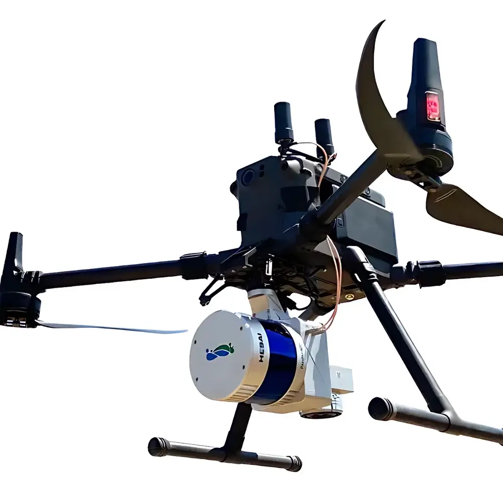
AERO LiDAR 220N UAV-Mounted Lightweight Topographic LiDAR System
| Brand | AERO |
|---|---|
| Model | LiDAR 220N |
| Weight | 2.0 kg |
| Maximum Range | 200 m |
| Field of View | 360° horizontal × 40° vertical (40-line rotating scan) |
| Integrated Sensors | 40-channel LiDAR + IMU + RGB camera |
| Positioning | GNSS-aided inertial navigation with cloud-based trajectory correction (base-station-free cm-level point cloud accuracy) |
| Origin | Beijing, China |
| Category | Antenna and Radar Cross Section Measurement System |
Overview
The AERO LiDAR 220N is a purpose-built, lightweight topographic LiDAR system engineered for integration onto multirotor unmanned aerial vehicles (UAVs). It operates on the principle of time-of-flight (ToF) laser ranging, utilizing a 40-line rotating scanner to emit near-infrared laser pulses (typically 905 nm) and precisely measure return signal travel time, enabling high-fidelity 3D point cloud generation. Unlike traditional ground-based or airborne LiDAR systems requiring external GNSS base stations for real-time kinematic (RTK) or post-processed kinematic (PPK) corrections, the LiDAR 220N implements an embedded cloud-trajectory correction technology—referred to as “CloudTrack”—which fuses raw GNSS observations, high-bandwidth IMU data (gyroscopes and accelerometers), and atmospheric modeling in near real time to deliver centimeter-level absolute geolocation accuracy without field-deployed reference stations. This architecture significantly reduces operational overhead while maintaining compliance with survey-grade spatial fidelity requirements for engineering-grade mapping applications.
Key Features
- Lightweight & UAV-Optimized Design: Total system mass of 2.0 kg ensures compatibility with Class II and III commercial UAV platforms (e.g., DJI Matrice 300 RTK, Autel EVO Max 4T), minimizing payload-induced flight time reduction and dynamic instability.
- 40-Line Full-360° Scanning Architecture: Provides continuous horizontal coverage at up to 1.2 million points per second, supporting high-density point cloud acquisition (average point spacing < 5 cm at 100 m altitude) under typical operational flight parameters (6–12 m/s forward speed, 60–120 m AGL).
- Integrated Sensor Fusion Core: Combines synchronized LiDAR, RGB imaging, and tactical-grade IMU (bias stability < 0.01°/hr, angular random walk < 0.005°/√hr) within a rigid aluminum alloy housing, ensuring geometric consistency across modalities for photogrammetric texturing and semantic classification workflows.
- Base-Station-Free Georeferencing: CloudTrack processing pipeline leverages global GNSS augmentation services (including IGS Real-Time Service and regional SBAS networks) to compute precise satellite orbit and clock corrections, eliminating dependency on local CORS infrastructure while meeting ISO 19157:2013 data quality criteria for positional accuracy (LE90 ≤ 3 cm horizontal, ≤ 5 cm vertical).
- Robust Operational Workflow: Supports one-touch mission initiation via onboard controller interface; all sensor synchronization, storage, and metadata tagging (including timestamped IMU quaternions and GNSS ephemeris) are handled autonomously during flight.
Sample Compatibility & Compliance
The LiDAR 220N is validated for deployment across heterogeneous terrain types—including forest canopies, urban infrastructure, transmission corridors, and flood-prone river basins—without hardware modification. Its optical design incorporates eye-safety certification per IEC 60825-1:2014 Class 1, and electromagnetic compatibility conforms to EN 55032:2015 (Class B) and EN 55035:2017. Data outputs adhere to industry-standard formats: LAS/LAZ 1.4 (with extended waveform and intensity attributes), GeoTIFF DSM/DTM rasters, and OGC-compliant WMS/WFS endpoints when ingested into enterprise GIS platforms. The system supports audit-ready metadata logging aligned with ISO 19115-1:2014 and meets functional prerequisites for GLP-aligned survey documentation in utility corridor inspection per IEEE Std 1458-2020.
Software & Data Management
AERO provides the proprietary AERO-GeoProcess Suite (v4.2+), a desktop application for point cloud calibration, boresight alignment, trajectory refinement, and automated classification (ground, vegetation, power lines, buildings) using rule-based and ML-enhanced algorithms. Raw data is stored on removable microSDXC cards (UHS-II rated) with full write integrity verification. All processing steps generate immutable audit logs compliant with FDA 21 CFR Part 11 requirements—including user authentication, action timestamps, parameter versioning, and electronic signature support—enabling traceability in regulated environments such as energy infrastructure compliance reporting.
Applications
- Electric power transmission line corridor monitoring: Detecting vegetation encroachment, conductor sag estimation, and tower component deformation analysis via multi-temporal point cloud differencing.
- Emergency rapid-response mapping: Generating orthomosaics and contour models within 2 hours of flight completion for disaster impact assessment (e.g., landslide volume calculation, flood extent delineation).
- Forestry inventory and biomass estimation: Deriving canopy height models (CHM), individual tree detection (ITD), and stand-level metrics (e.g., basal area, DBH distribution) through structure-from-motion (SfM)-augmented LiDAR fusion.
- Topographic surveying for civil infrastructure: Supporting earthwork volume computation, road centerline extraction, and drainage network modeling in accordance with ASTM D6429-21 and ASCE 7-22 load-path assumptions.
FAQ
Does the LiDAR 220N require a local GNSS base station for centimeter-level accuracy?
No. It utilizes CloudTrack—a cloud-based PPK solution—that processes raw GNSS observables against globally distributed reference networks, delivering cm-level absolute positioning without field-deployed infrastructure.
What is the maximum operational altitude above ground level (AGL) recommended for optimal point density?
For ≥100 pts/m² average density, the recommended AGL range is 60–100 m; performance remains quantitatively valid up to 150 m AGL with adjusted flight speed and overlap settings.
Is the system compatible with third-party flight planning software such as Pix4Dcapture or UgCS?
Yes. The LiDAR 220N exposes standardized MAVLink telemetry interfaces and supports mission file ingestion via GPX/KML, enabling interoperability with major UAV autonomy ecosystems.
How is radiometric calibration of the integrated RGB camera performed?
Factory-calibrated using NIST-traceable flat-field targets; users may perform optional field-based re-calibration using AERO’s included X-Rite ColorChecker Passport workflow.
Can the system be operated in rain or fog?
Operation is not recommended in precipitation or visibility < 500 m due to laser beam attenuation and increased noise in returned signals; however, the IP54-rated enclosure provides protection against dust and incidental water exposure during dry-weather operations.


