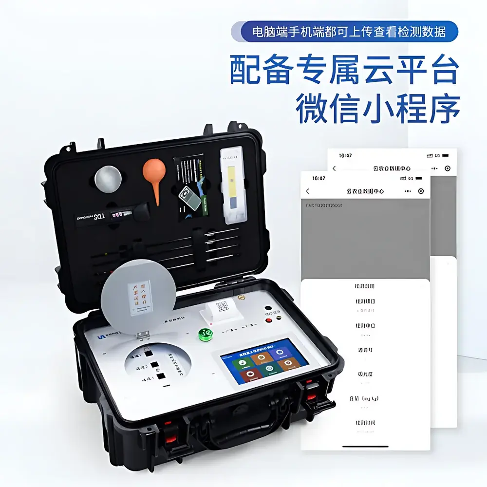
AZ ST-W2 Soil Profile Water Erosion Measurement System
| Brand | AZ (Beijing AoZuo) |
|---|---|
| Origin | Beijing, China |
| Manufacturer | Yes |
| Country of Origin | China |
| Model | ST-W2 |
| Instrument Type | Soil Water Erosion & Runoff Monitoring System |
| Power Supply | 220 VAC (solar option available) |
| Sampling Bottles | 24 total (12 for surface runoff + 12 for subsurface flow) |
| Bottle Capacity | 500 mL each |
| Flow Measurement | Tipping-bucket sensor (500 mL per tip) |
| Data Logger | Programmable 18-bit A/D converter (±0.025% accuracy), 128 MB internal memory (130,000 readings), USB 1.1/2.0 & RS-232 & Ethernet interfaces |
| Operating Temperature | −45 to +70 °C |
| Clock Accuracy | ±1 min/year (0–40 °C), ±4 min/year (−40–70 °C) |
| Sampling Interval | 10 ms to 24 h (user-defined) |
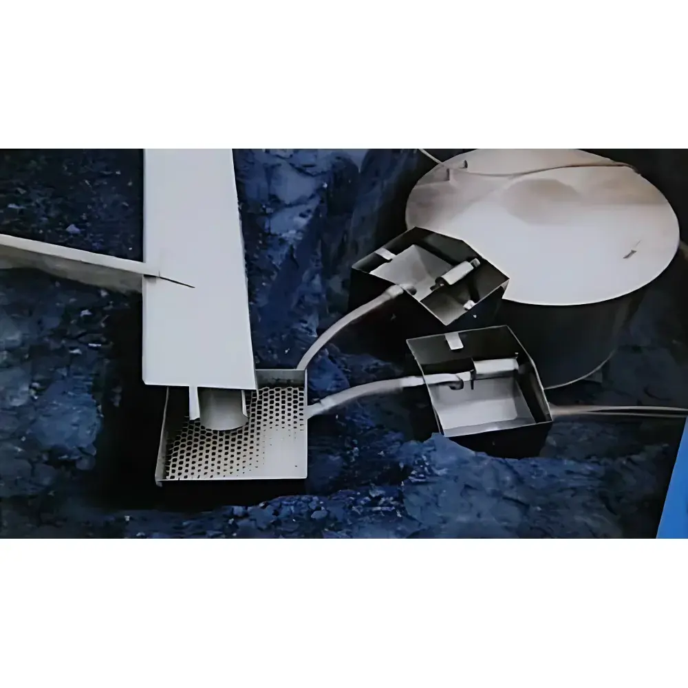
| Flow Channel | Dual-layer diverter system with 3 m stainless-steel guide trough (upper width: 52 mm |
| lower outlet | 35 mm) |
| Slope Range for Runoff Plot | 10–20° (optimized) |
| Output Metrics | Mean, max, min, sample, vector, cumulative values |
Overview
The AZ ST-W2 Soil Profile Water Erosion Measurement System is an integrated, field-deployable hydrological monitoring platform engineered for quantitative assessment of soil erosion dynamics across the soil–water interface. It operates on the physical principle of spatially resolved runoff partitioning—separating and simultaneously quantifying surface runoff and subsurface (interflow) components within a defined erosion plot. By combining precision mechanical flow measurement (via calibrated tipping-bucket transducers), programmable sequential sampling, and synchronized environmental data acquisition, the ST-W2 enables researchers to resolve temporal and compositional relationships between rainfall events, infiltration thresholds, sediment detachment, and solute transport. Designed for long-term unattended operation in remote or rugged terrain, the system adheres to core principles of hydrological mass balance and sediment yield estimation as outlined in ISO 11274 (soil water retention), ASTM D4318 (liquid limit), and FAO guidelines for land degradation monitoring.
Key Features
- Automated dual-path sampling architecture: 12 bottles for surface runoff and 12 for subsurface interflow—enabling parallel geochemical and granulometric analysis of eroded material.
- High-fidelity tipping-bucket flowmeter (500 mL resolution) with temperature-compensated calibration traceable to NIST standards.
- Microprocessor-based data logger featuring 18-bit A/D conversion (±0.025% full-scale accuracy), onboard 128 MB non-volatile memory, and real-time clock stability of ±1 minute per year (0–40 °C).
- Modular expandability: Optional meteorological sensor suite (rainfall, wind speed/direction, air temperature/humidity, solar radiation, barometric pressure) and soil hydric module (volumetric water content, matric potential, soil temperature, infiltration rate, evaporation flux).
- Configurable sampling logic: Time-triggered, event-triggered, or volume-triggered collection with user-defined intervals (10 ms to 24 h) and stage-based bottle sequencing.
- Ruggedized mechanical design: Stainless-steel 3 m guide trough (dual-section geometry: 52 mm upper aperture, 35 mm lower outlet), corrosion-resistant分流 box, and IP67-rated electronics enclosure.
- Power flexibility: Standard 220 VAC input with optional photovoltaic charging system (12 VDC nominal, compatible with deep-cycle battery banks).
Sample Compatibility & Compliance
The ST-W2 supports standard 500 mL polyethylene or amber glass sampling bottles compliant with EPA Method 1664A (oil and grease) and ISO 5667-3 (water sampling preservation). Its dual-layer flow separation mechanism satisfies the requirements of USGS Techniques and Methods Report 3-A22 for distinguishing Hortonian overland flow from throughflow in hillslope hydrology studies. All electronic modules conform to IEC 61326-1 (EMC for laboratory and industrial use) and operate within Class II pollution degree environments. Data integrity protocols align with GLP-compliant field data acquisition practices, including timestamped metadata embedding, audit-trail-capable firmware logging, and CRC-32 error checking on all stored records.
Software & Data Management
System configuration, real-time telemetry, and post-processing are managed via Ecograph—a Windows-based desktop application supporting drag-and-drop channel mapping, script-driven sampling logic, and automated export to CSV, Excel, or SQL databases. The software implements hierarchical data validation: raw sensor inputs undergo linearization, thermal drift correction, and outlier rejection prior to storage. Exported datasets include synchronized timestamps (UTC), cumulative volume totals, bottle assignment indices, and optional auxiliary sensor metadata. For regulatory reporting, Ecograph generates PDF summary reports with embedded calibration certificates and QA/QC flags—fully compatible with FDA 21 CFR Part 11 requirements when deployed with digital signature and user access control modules.
Applications
- Quantitative evaluation of soil loss under varying land-use scenarios (e.g., afforestation vs. cropland abandonment) in mountainous catchments.
- Validation of erosion prediction models (e.g., RUSLE, WEPP, MMF) by providing high-resolution, plot-scale sediment yield and nutrient export time series.
- Long-term monitoring of slope stability precursors in landslide-prone zones, correlating interflow onset with pore-water pressure thresholds.
- Ecological restoration trials assessing hydrological recovery metrics—such as infiltration recovery rate, runoff coefficient reduction, and sediment concentration decay—in degraded forest ecosystems.
- Soil physics research on preferential flow pathways, macropore connectivity, and lateral redistribution of agrochemicals in structured soils.
- Calibration and ground-truthing of satellite-based soil moisture and surface runoff products (e.g., SMAP, GPM, Sentinel-1 SAR).
FAQ
Can the ST-W2 distinguish between sediment-laden runoff and clear interflow in real time?
Yes—the system relies on physical flow path separation rather than optical or acoustic sensing. Surface runoff enters the upper guide trough and is routed to the tipping bucket and surface sampling train; subsurface flow is collected independently via a dedicated 30 cm-depth collector trench feeding into the lower sampling manifold.
Is the data logger compatible with third-party sensors beyond the AZ ecosystem?
Yes—it supports analog (0–5 V, 4–20 mA) and digital (SDI-12, RS-485 Modbus RTU) inputs, enabling integration with certified Campbell Scientific, Decagon (now METER), or Onset HOBO sensors.
How is calibration maintained during extended deployments?
The tipping bucket includes a built-in verification port for manual volumetric calibration using certified graduated cylinders; firmware logs all calibration events with operator ID and timestamp.
What is the minimum detectable runoff volume per sampling event?
With the 500 mL tipping bucket and configurable 1-minute minimum sampling interval, the system resolves runoff events ≥0.5 L at sub-hourly resolution—sufficient to capture early-stage Hortonian flow initiation in most loam-to-clay soils.
Does the system support remote data retrieval via cellular or satellite link?
While the base unit lacks embedded telemetry, its Ethernet and USB interfaces allow seamless integration with commercial cellular gateways (e.g., Sierra Wireless AirLink, Teltonika RUT955) or Iridium short-burst data modems for off-grid telemetry.
Related Products