AZUP SE-40/70/150 Airborne Ground-Penetrating Radar System
| Brand | AZUP |
|---|---|
| Origin | Sweden |
| Manufacturer | AZUP Technologies AB |
| Type | Airborne GPR Platform |
| Models | SE-40 / SE-70 / SE-150 |
| Center Frequencies | 52 MHz / 80 MHz / 124 MHz |
| Frequency Bands | 15–105 MHz / 20–140 MHz / 20–280 MHz |
| Dynamic Range | 192 dB (32-bit) |
| Time Window | 0–1600 ns |
| Sampling Interval | 3.125 ns (320 MHz) |
| Stacking Rate | 32,000 shots/sec (45 dB SNR improvement) |
| Pulse Repetition Frequency | 156 kHz |
| Max Penetration (Airborne/Ground/Freshwater) | 15/30/— m / 10/20/9 m / 8/15/5 m |
| Vertical/Horizontal Resolution | 48/141 cm / 31/88 cm / 21/59 cm |
| Operating Temperature | −20 °C to +50 °C |
| Dimensions (L×W×H) | 200×15×21 cm / 139×15×21 cm / 92×22×21 cm |
| Weight | 5.8 kg / 4.9 kg / 4.6 kg |
| Compatible UAV Payload Capacity | ≥6 kg / ≥5 kg / ≥5 kg |
| Data Acquisition Software | DAQ |
| Post-Processing Software | PRISM |
Overview
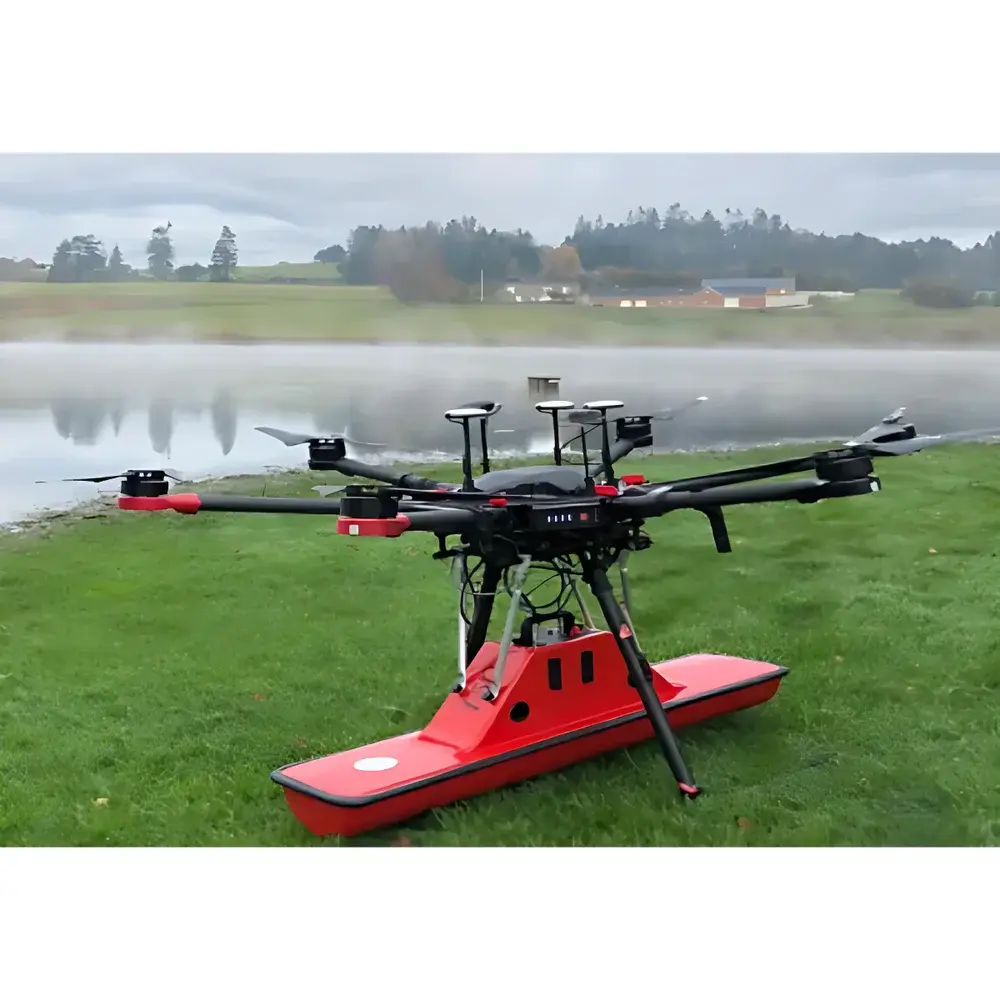
The AZUP SE-40/70/150 Airborne Ground-Penetrating Radar (GPR) System is a modular, drone-integrated geophysical sensing platform engineered for high-efficiency subsurface mapping across diverse terrain and environmental conditions. Unlike conventional ground-coupled GPR surveys—which require labor-intensive grid-based traverses—the SE-series leverages airborne deployment to achieve rapid, non-invasive coverage of large or inaccessible areas including glacial ice sheets, permafrost zones, alluvial plains, urban infrastructure corridors, and freshwater bodies. The system operates on the principle of ultra-wideband electromagnetic pulse transmission and time-domain reflection analysis: short-duration radio pulses (centered at 52 MHz, 80 MHz, or 124 MHz depending on configuration) propagate into the subsurface; dielectric contrasts at material interfaces generate reflected signals captured by synchronized receiving antennas. Time-of-flight measurements, calibrated against known velocity models, enable depth estimation with centimeter-to-meter vertical resolution—dependent on antenna frequency, host medium permittivity, and signal-to-noise ratio.
Key Features
- Modular antenna architecture supporting interchangeable SE-40, SE-70, and SE-150 antenna modules—each optimized for specific depth-resolution trade-offs in geological, hydrological, or anthropogenic contexts.
- High-fidelity 32-bit digitization with 192 dB dynamic range ensures detection of weak late-time reflections from deep targets while preserving shallow-layer contrast.
- Real-time stacking capability at up to 32,000 pulses per second enhances signal coherence and suppresses random noise without compromising survey speed.
- Ultra-stable timing control with 3.125 ns sampling interval (320 MHz equivalent) supports precise two-way travel time measurement critical for depth calibration and migration processing.
- Compact, low-mass mechanical design: all three variants weigh under 6 kg and feature standardized mounting interfaces compatible with commercial UAV platforms rated for ≥5 kg payload capacity.
- Extended operational temperature range (−20 °C to +50 °C) enables year-round deployment in arctic, alpine, desert, and tropical environments without thermal drift-induced gain or timing instability.
Sample Compatibility & Compliance
The SE-40/70/150 system is validated for use in heterogeneous media including dry sand, saturated clay, granitic bedrock, freshwater-saturated sediments, glacial ice, snowpack, asphalt/concrete pavements, and reinforced concrete structures. Its frequency-agile design allows selection of optimal center frequency based on target depth and expected attenuation: SE-40 (52 MHz) prioritizes penetration (up to 30 m in dry soils), SE-70 (80 MHz) balances resolution and depth (e.g., utility mapping, levee integrity assessment), and SE-150 (124 MHz) delivers enhanced lateral discrimination for shallow archaeological features or pavement layer analysis. All configurations comply with international electromagnetic compatibility standards (IEC 61000-6-3/6-4) and meet CE marking requirements for airborne instrumentation. Data acquisition workflows support audit-ready metadata tagging—including GPS time synchronization, IMU orientation, altitude telemetry, and sensor calibration checksums—facilitating adherence to ISO 17025-accredited laboratory practices and GLP-compliant field reporting protocols.
Software & Data Management
Data acquisition is managed via AZUP’s proprietary DAQ software, which provides real-time display of A-scan envelopes, B-scan raster previews, and live signal quality metrics (e.g., RMS noise floor, peak amplitude stability). DAQ supports direct integration with third-party UAV flight controllers (e.g., Pixhawk-based autopilots) through MAVLink telemetry, enabling automated trigger synchronization and georeferenced trace stamping. Post-processing is performed using PRISM—a comprehensive GPR analysis suite featuring migration algorithms (Kirchhoff, phase-shift), gain compensation (AGC, deconvolution), filtering (F-K, bandpass), hyperbola fitting, and volumetric visualization tools. PRISM exports georeferenced data in industry-standard formats (SEG-Y, LAS, GeoTIFF) and maintains full audit trails per session, including raw binary headers, processing history logs, and user-defined annotation layers—ensuring compliance with FDA 21 CFR Part 11 requirements for electronic records and signatures where applicable.
Applications
- Geotechnical site characterization for civil infrastructure planning (bridge abutments, tunnel alignment, landfill base integrity).
- Permafrost and glacier thickness monitoring in climate change research programs.
- Subsurface utility locating and void detection beneath roadways and airport runways.
- Aquifer mapping and groundwater table delineation in arid and semi-arid regions.
- Archaeological prospection of buried foundations, walls, and burial chambers without excavation.
- Forensic search operations for clandestine graves or evidence concealment in soil or debris.
- Post-disaster assessment of landslide slip surfaces, sinkhole development, and flood-damaged levee systems.
- Military applications including unexploded ordnance (UXO) detection and border surveillance infrastructure verification.
FAQ
What distinguishes the SE-40, SE-70, and SE-150 antenna modules in terms of physical deployment constraints?
The SE-40 requires UAV platforms with ≥6 kg payload capacity due to its larger physical footprint (200 cm length); SE-70 and SE-150 are optimized for ≥5 kg platforms and offer reduced drag profiles suitable for extended endurance flights.
Can the system operate over saltwater or highly conductive sediments?
No—electromagnetic attenuation in saline water or clay-rich soils severely limits penetration; the system is specified for freshwater bodies and resistive geological media only.
Is firmware upgrade support available remotely?
Yes—AZUP provides secure OTA (over-the-air) firmware updates via encrypted SSH channels, with version rollback capability and cryptographic signature verification.
Does PRISM support batch processing of multi-flight datasets?
Yes—PRISM includes scripting interfaces (Python API) and job queue management for automated processing pipelines across hundreds of GPR lines.
Are calibration certificates traceable to national metrology institutes?
Each unit ships with NIST-traceable timebase and amplitude calibration reports, valid for 12 months from date of manufacture.
Related Products


