CASP AGHJ-I Dual-Wavelength Three-Channel Atmospheric Aerosol Lidar
| Brand | CASP (China Academy of Sciences Photonics) |
|---|---|
| Origin | Jiangsu, China |
| Manufacturer Type | Original Equipment Manufacturer (OEM) |
| Product Category | Domestic |
| Model | AGHJ-I-LIDAR |
| Laser Source | Nd:YAG pulsed laser |
| Operating Wavelengths | 355 nm and 532 nm |
| Maximum Detection Altitude | ≥20 km |
| Polarization Channels | Co-located vertical and horizontal polarization at 532 nm |
| Detection Principle | Mie scattering-based elastic backscatter lidar |
| Optical Architecture | Coaxial transmit/receive design |
| Pulse Energy | Millijoule-level per pulse |
| Minimum Detectable Particle Radius | ~5 nm |
| Data Output | Real-time atmospheric profiling including extinction coefficient, backscatter ratio, depolarization ratio, optical depth, PBL height, cloud base/top height, visibility, PM₁₀ spatiotemporal evolution, Ångström exponent, dust transport flux, and cloud classification |
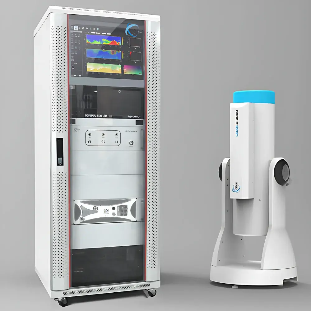
Overview
The CASP AGHJ-I Dual-Wavelength Three-Channel Atmospheric Aerosol Lidar is a ground-based, eye-safe, elastic backscatter lidar system engineered for continuous, unattended monitoring of atmospheric aerosols, clouds, and boundary layer structure. It operates on the fundamental principle of Mie scattering, where short-pulse laser radiation interacts with suspended particulate matter and hydrometeors, generating wavelength-dependent backscattered signals proportional to particle size, shape, and refractive index. By simultaneously emitting at 355 nm and 532 nm—and detecting the 532 nm return in both vertical and horizontal polarization states—the system enables robust discrimination of particle microphysical properties. This dual-wavelength, triple-channel configuration supports quantitative retrieval of extinction coefficients, depolarization ratios, and backscatter profiles with high vertical resolution (≤7.5 m) and temporal resolution (1–60 min averaging), making it suitable for long-term operational deployment in national air quality networks, research observatories, and early-warning systems for dust storms and haze events.
Key Features
- Millijoule-class Nd:YAG laser source delivering stable, high-energy pulses at 355 nm and 532 nm—enhancing signal-to-noise ratio and extending effective detection range to ≥20 km
- Coaxial optical architecture minimizing near-range blind zone and preventing detector saturation from strong low-altitude scattering
- Triple-channel detection: 355 nm total backscatter + 532 nm co-polarized and cross-polarized channels—enabling particle shape and phase identification (e.g., spherical vs. non-spherical, liquid vs. crystalline)
- Real-time, automated operation via industrial control computer; supports 24/7 unattended acquisition with remote diagnostics and firmware update capability
- Integrated thermal management and environmental enclosure rated for outdoor deployment across wide temperature (-20 °C to +50 °C) and humidity ranges
- Compliance-ready data logging architecture supporting audit trails, timestamped metadata, and raw signal storage in HDF5 or NetCDF format
Sample Compatibility & Compliance
The AGHJ-I Lidar is designed for open-air atmospheric sampling without sample preparation or consumables. It is compatible with ambient air containing submicron to coarse-mode aerosols—including mineral dust, sea salt, biomass burning smoke, urban PM₂.₅/PM₁₀, volcanic ash, and cloud droplets/ice crystals. Its measurement methodology aligns with established international observational frameworks, including EARLINET (European Aerosol Research Lidar Network) calibration protocols and WMO/GAW (World Meteorological Organization/Global Atmosphere Watch) guidelines for aerosol profiling. The system supports traceable calibration using built-in Rayleigh-atmosphere reference and optional Raman channel integration. Data output formats comply with ISO 14644-1 cleanroom standards for particle concentration reporting and are structured to facilitate ingestion into EPA AQS, EEA AirBase, and Copernicus Atmosphere Monitoring Service (CAMS) workflows.
Software & Data Management
The proprietary CASP Lidar Analysis Suite (CLAS) provides a Windows-based GUI with modular architecture for instrument control, real-time visualization, and offline inversion. CLAS implements multi-wavelength Fernald-Klett and Klett-Eloranta algorithms for extinction coefficient retrieval, alongside polarimetric inversion routines for particle linear depolarization ratio (δ). All processed products—including planetary boundary layer (PBL) height, cloud mask, optical depth, Ångström exponent, and dust transport flux—are generated automatically without manual intervention. The software includes API interfaces (RESTful HTTP and TCP/IP socket) for integration with SCADA systems, cloud platforms (AWS S3, Azure Blob), and national environmental data centers. Audit logs record all user actions, parameter changes, and calibration events in accordance with GLP and ISO/IEC 17025 requirements. Raw signal files retain full photon-counting resolution and support reprocessing under updated inversion schemes.
Applications
- Long-term monitoring of aerosol vertical distribution and transport pathways over urban, rural, coastal, and desert regions
- Dust storm early warning and source attribution through real-time identification of elevated depolarizing layers and backward trajectory analysis
- Validation of satellite aerosol products (e.g., CALIOP, CATS, EarthCARE) and regional chemistry-transport models (WRF-Chem, CMAQ, CAMx)
- Boundary layer meteorology studies—diurnal evolution of mixing height, residual layer persistence, and entrainment zone characterization
- Cloud-aerosol interaction research, including mixed-phase cloud detection and ice nucleation layer identification
- Regulatory compliance support for national PM₂.₅/PM₁₀ monitoring programs requiring vertical context beyond surface station data
FAQ
What atmospheric parameters does the AGHJ-I Lidar directly measure?
It directly measures time-resolved elastic backscatter signals at 355 nm and 532 nm (co- and cross-polarized), from which extinction coefficient, backscatter coefficient, depolarization ratio, optical depth, and PBL height are quantitatively retrieved.
Can the system operate autonomously for extended periods?
Yes—it is designed for continuous, unattended operation with integrated power management, environmental monitoring, and remote reboot capability. Typical field deployments exceed 6 months without physical intervention.
Is the data compatible with international lidar networks such as EARLINET or ACTRIS?
Yes—data formatting, metadata tagging, and calibration traceability follow EARLINET Level 2 product specifications. Optional certification by certified EARLINET calibration centers is available.
Does the system meet regulatory requirements for environmental monitoring agencies?
The hardware and software architecture support 21 CFR Part 11-compliant electronic records when deployed with validated authentication and audit trail modules, fulfilling GMP/GLP-aligned data integrity requirements for official reporting.
What is the minimum detectable particle radius, and how is it determined?
The theoretical lower limit is approximately 5 nm, derived from Mie scattering cross-section sensitivity at 355 nm under typical atmospheric number concentrations and system signal-to-noise performance—validated against SMPS and DMA reference measurements in intercomparison campaigns.
Related Products


