CRS-1000/B Cosmic-Ray Neutron Probe (CRNP) Soil Moisture Measurement System
| Origin | USA |
|---|---|
| Manufacturer Type | Authorized Distributor |
| Origin Category | Imported |
| Model | CRS-1000/B |
| Pricing | Available Upon Request |
Overview
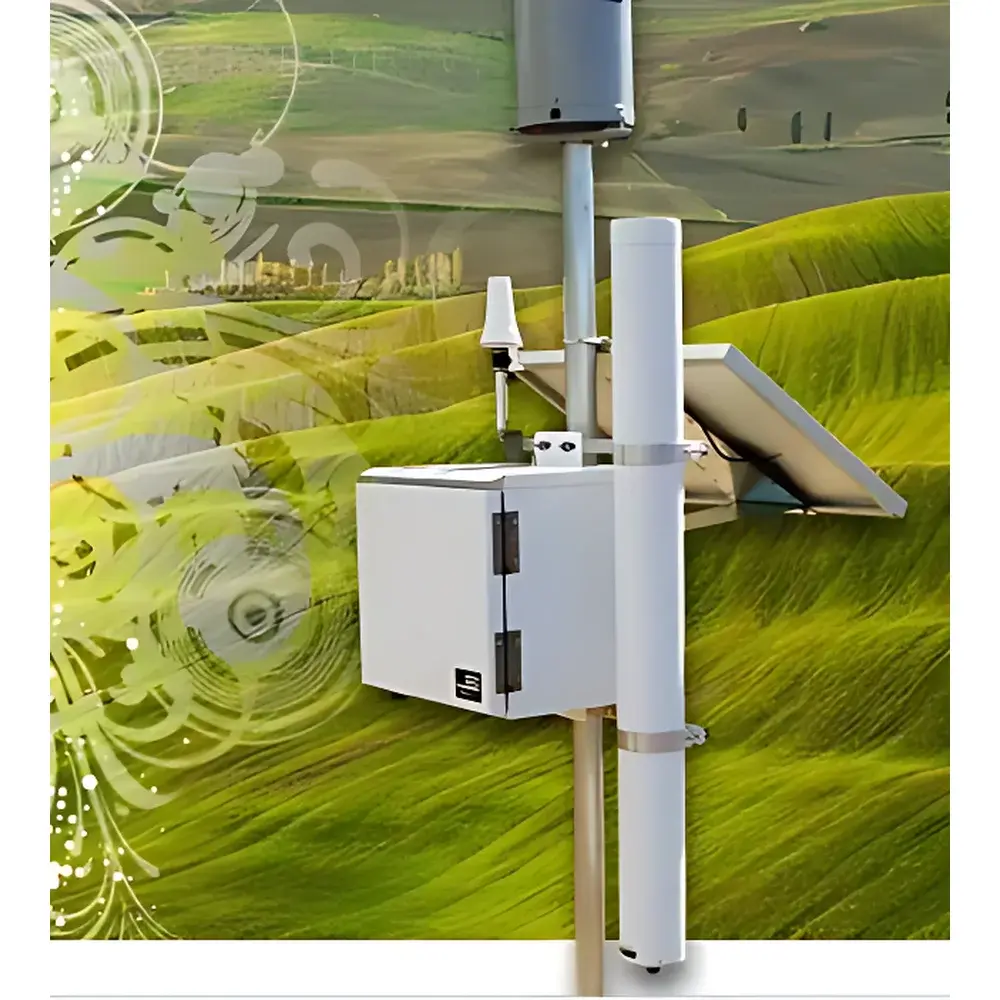
The CRS-1000/B Cosmic-Ray Neutron Probe (CRNP) Soil Moisture Measurement System is a field-deployable, non-invasive geophysical instrument engineered for continuous, area-integrated estimation of near-surface soil water content. It operates on the well-established principle of cosmic-ray neutron sensing (CRNS), leveraging naturally occurring secondary neutrons generated by galactic cosmic rays interacting with Earth’s atmosphere and surface materials. High-energy neutrons produced in these interactions undergo elastic scattering—primarily with hydrogen nuclei—within the top ~70 cm of soil and vegetation. As hydrogen concentration correlates strongly with water content (H₂O, organic matter, snow), the intensity of epithermal (fast) neutrons escaping to the land surface exhibits an inverse exponential relationship with volumetric water content across a footprint of up to 350 m radius (~700 m diameter). This physics-based, passive measurement approach eliminates the need for soil penetration, calibration against local texture or salinity, and avoids radiation sources—making it uniquely suited for long-term, unattended monitoring in heterogeneous landscapes.
Key Features
- Passive detection of epithermal neutrons—no radioactive source or ionizing radiation required
- Non-contact, non-destructive operation—no soil disturbance or sensor insertion
- Large-scale spatial integration: effective measurement footprint of up to 700 m diameter (≈38 ha)
- Depth sensitivity: weighted average over the upper 0–70 cm soil layer, with exponential attenuation
- Minimal sensitivity to soil texture, bulk density, salinity, and surface roughness—enabling cross-site comparability
- Low-power architecture: nominal current draw of 95 mA at 12 VDC; fully compatible with solar-rechargeable power systems
- Flexible temporal resolution: configurable data acquisition intervals from 1 minute to 1 year
- Integrated environmental sensing: co-located barometric pressure, air temperature, and relative humidity sensors for neutron intensity correction
- Modular expandability: optional integration of tipping-bucket rain gauges, TDR probes, or snow depth sensors
Sample Compatibility & Compliance
The CRS-1000/B is designed for deployment across diverse terrestrial ecosystems—including agricultural fields, rangelands, forests, tundra, and snow-covered alpine basins. Its measurement principle is inherently insensitive to soil chemistry, making it applicable in saline, clay-rich, or highly organic soils where traditional dielectric or capacitance sensors exhibit significant bias. The system complies with IEC 61326-1 (EMC requirements for laboratory and industrial use) and meets CE marking directives for electromagnetic compatibility and low-voltage safety. Data integrity protocols support GLP-aligned field operations; metadata tagging (time stamp, GPS location, atmospheric conditions) ensures traceability for scientific validation and regulatory reporting. While not a medical or nuclear device, its neutron detection methodology adheres to ANSI/ANS-6.4.3 guidelines for environmental neutron monitoring instrumentation.
Software & Data Management
Data acquisition and real-time processing are managed via an embedded Linux-based data logger with dual SD card slots—one internal for primary logging, one user-replaceable for backup or extended campaigns. Raw neutron counts, corrected neutron intensities, and derived volumetric water content (cm³/cm³) are stored in CSV and NetCDF formats compliant with FAO and USDA Soil Moisture Network standards. USB and RS-232 interfaces enable local configuration and data retrieval; optional GSM or Iridium satellite telemetry modules support remote data transmission with configurable retry logic and payload compression. The accompanying HydroView™ desktop application provides automated correction routines—including atmospheric pressure normalization, incoming neutron flux adjustment (via NOAA’s NMDB database), and vegetation water content compensation—using peer-reviewed algorithms published in Water Resources Research and Vadose Zone Journal. Audit trails, user access logs, and timestamped firmware versioning satisfy requirements for ISO/IEC 17025-accredited environmental monitoring programs.
Applications
- Calibration and validation of satellite-based soil moisture products (e.g., SMAP, Sentinel-1, ASCAT)
- Ground-truthing for land surface models (LSMs) used in numerical weather prediction and climate reanalysis
- Regional irrigation scheduling and water balance accounting in precision agriculture
- Early-warning monitoring for drought onset and flood risk assessment in watershed management
- Long-term ecohydrological studies linking soil moisture dynamics to carbon fluxes, evapotranspiration, and plant phenology
- Snow water equivalent (SWE) estimation in mountainous catchments during accumulation and melt periods
- Supporting FAO’s AQUASTAT and WMO’s Global Cryosphere Watch initiatives through standardized, open-format data contribution
FAQ
How does the CRS-1000/B differ from point-scale sensors like TDR or FDR probes?
It measures area-averaged soil moisture over hectare-scale footprints—not localized values—reducing spatial sampling error and eliminating representativeness bias inherent in sparse point networks.
Does soil salinity affect measurement accuracy?
No. Unlike electromagnetic methods, CRNS relies on neutron-hydrogen interactions; ionic conductivity has negligible influence on epithermal neutron moderation or escape probability.
Can the system operate autonomously for >12 months?
Yes—when paired with a ≥40 Ah solar-charged battery bank and optimized duty cycling, multi-year deployments without maintenance are routinely achieved in mid-latitude sites.
Is atmospheric correction mandatory?
Yes. Barometric pressure and incoming neutron flux variations induce up to ±8% signal drift; integrated sensors and external database linkage ensure sub-2% residual uncertainty in final soil moisture estimates.
What is the minimum recommended installation height above ground?
2 m above the soil surface is standard; lower heights increase vegetation interference, while heights >3 m reduce signal-to-noise ratio due to atmospheric neutron absorption.
Related Products