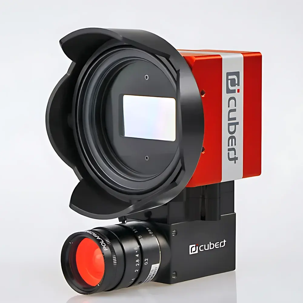
Cubert X20P Airborne Hyperspectral Imaging System
| Brand | Cubert |
|---|---|
| Origin | Germany |
| Model | X20P |
| Spectral Range | 350–1000 nm |
| Spectral Resolution | 1886 × 1886 pixels per frame |
| Radiometric Resolution | 12-bit |
| Field of View (TFOV) | 35° |
| Instantaneous Field of View (IFOV) | >2 cubes/s, 1886 × 1886 pixels per cube |
| Imaging Modality | Snapshot (Focal Plane Array-based) |
| Deployment | Airborne & Ground-based |
| Interface | Dual GigE Vision |
| Frame Rate | Up to 5 Hz (full-resolution) |
| Core Sensor | 20 MP monolithic CMOS |
| Onboard Processing | Integrated brushless gimbal, embedded controller, and solid-state storage |
| Compliance | CE, RoHS, ISO 9001-manufactured |
Overview
The Cubert X20P Airborne Hyperspectral Imaging System is a snapshot (frame-based) hyperspectral imager engineered for high-fidelity spectral-spatial data acquisition in dynamic airborne environments. Unlike scanning-based or push-broom systems, the X20P leverages patented light-field hyperspectral technology—implemented via a monolithic 20-megapixel CMOS sensor coupled with a custom micro-lens array and dispersion optics—to capture full 1886 × 1886 pixel spatial frames across 325 simultaneously resolved spectral channels within the 350–1000 nm range. This snapshot architecture eliminates motion-induced artifacts (e.g., spatial misregistration, keystone distortion), ensuring radiometric integrity and geometric consistency essential for quantitative remote sensing applications. Designed for integration on both fixed-wing and multi-rotor UAV platforms—including VTOL configurations—the X20P operates without moving optical components, delivering robust performance under vibration, acceleration, and thermal cycling typical of aerial deployment.
Key Features
- Snapshot acquisition: Captures full 1886 × 1886 pixel hyperspectral cubes at up to 5 Hz via dual GigE Vision interface—enabling real-time downlink or onboard solid-state storage.
- Monolithic CMOS architecture: Eliminates mechanical scanning, reducing failure points and enabling stable calibration retention across flight cycles.
- Integrated brushless 3-axis gimbal: Provides active stabilization and precise attitude control; supports direct mounting on DJI Matrice 300 RTK, Autel EVO Max 6T, or heavy-lift platforms such as the A660 and AZCW series.
- Onboard embedded processing unit: Executes real-time metadata tagging (GPS/IMU synchronization), lossless compression (Huffman + predictive coding), and configurable region-of-interest (ROI) extraction.
- 12-bit radiometric depth with low read noise (<5 e⁻ RMS): Optimized for high signal-to-noise ratio (SNR) in low-light conditions and reflective surface analysis.
- Calibration traceability: Factory-calibrated against NIST-traceable standards; includes spectral response function (SRF), dark current, and flat-field correction datasets.
Sample Compatibility & Compliance
The X20P is optimized for non-contact reflectance and radiance measurements of terrestrial and aquatic surfaces—including vegetation canopies, soil substrates, mineral outcrops, and inland water bodies. Its 35° total field of view enables efficient swath coverage during medium-altitude surveys (100–500 m AGL), while the IFOV specification (>2 cubes per second) ensures temporal coherence for fast-moving platforms. The system complies with EU regulatory frameworks including CE marking (EMC Directive 2014/30/EU, RoHS Directive 2011/65/EU) and is manufactured under an ISO 9001-certified quality management system. Data output formats (ENVI .hdr/.bin, GeoTIFF with embedded GDAL-compliant georeferencing) support interoperability with GIS workflows compliant with OGC standards. While not FDA-regulated, its radiometric stability and audit-ready metadata logging align with GLP principles for environmental monitoring and agricultural research.
Software & Data Management
Cubert’s proprietary UHD-Analyzer software suite provides end-to-end processing—from raw cube ingestion to georeferenced spectral mosaics. Key modules include automated atmospheric correction (using MODTRAN-based look-up tables), spectral unmixing (constrained least-squares), vegetation index computation (NDVI, EVI, PRI, NDRE), and supervised classification (SVM, Random Forest). All processing steps generate immutable audit trails compliant with 21 CFR Part 11 requirements when deployed in validated laboratory environments. Export options include ASCII spectral libraries, shapefile-embedded thematic maps, and NetCDF-4 files with CF-1.7 metadata conventions. API access (Python/C++ SDK) enables integration into custom UAV mission planning pipelines (e.g., Mission Planner, QGroundControl extensions) and cloud-based analytics platforms (AWS Ground Station, Google Earth Engine).
Applications
- Agricultural monitoring: Precision phenotyping, nitrogen status mapping, stress detection (drought, disease, herbicide drift) at sub-field resolution.
- Environmental assessment: Wetland delineation, invasive species identification, chlorophyll-a estimation in reservoirs and coastal zones.
- Geological surveying: Lithological mapping, hydrothermal alteration zone detection, and rare-earth element proxy analysis via diagnostic absorption features.
- Forestry management: Canopy structure modeling, biomass estimation, post-fire regeneration tracking.
- Urban remote sensing: Material classification (roofing types, pavement aging), solar reflectance indexing (SRI), and heat island analysis.
FAQ
What distinguishes the X20P from push-broom hyperspectral sensors?
The X20P acquires full spatial-spectral data cubes instantaneously—no spatial scanning required—eliminating motion artifacts and enabling use on agile UAVs without strict forward-motion constraints.
Is radiometric calibration performed before delivery?
Yes. Each unit ships with factory-applied wavelength calibration, relative spectral response (RSR), and radiometric gain/offset coefficients traceable to NIST SRM 2035 and 1920 standards.
Can the X20P operate without external GNSS/IMU?
It supports standalone operation using its internal IMU and optional integrated RTK GNSS module; however, georeferencing accuracy improves significantly when fused with external PPK/RTK solutions.
What spectral resampling options are available in UHD-Analyzer?
Users may apply Gaussian convolution, Savitzky-Golay smoothing, or user-defined band averaging to reduce dimensionality while preserving key absorption features.
Does the system support real-time onboard processing?
Basic preprocessing (dark subtraction, flat-field correction, JPEG2000 compression) occurs onboard; advanced analytics require post-flight processing on desktop or server infrastructure.
Related Products


")
