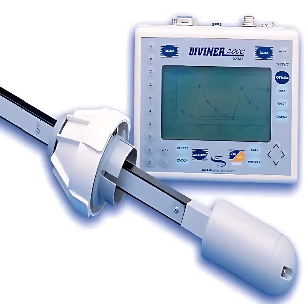
Diviner2000 Portable Soil Moisture Profiler
| Origin | Beijing, China |
|---|---|
| Manufacturer Type | Distributor |
| Origin Category | Domestic |
| Model | Diviner2000 |
| Pricing | Upon Request |
| Instrument Type | Soil Moisture / Water Potential Analyzer |
| Measurement Principle | Frequency Domain Reflectometry (FDR) |
| Max. Profile Points | 99 |
| Depth Options | 0.7 m / 1.0 m / 1.6 m |
| Display Unit Dimensions | 190 × 38 × 45 mm |
| Display Unit Weight | 900 g |
| Power Supply | 13.8 VDC, 800 mA Charger |
| Measurement Accuracy | ±1% volumetric water content |
| PVC Access Tube Lengths | 1.0 m / 1.5 m / 2.0 m |
| Probe Total Lengths | 1.13 m / 1.53 m / 2.13 m |
| Measurement Range | Dry to Saturation |
Overview
The Diviner2000 Portable Soil Moisture Profiler is an engineered field instrument designed for rapid, non-destructive vertical profiling of volumetric soil water content using Frequency Domain Reflectometry (FDR) technology. Built upon the validated EnviroSCAN measurement architecture, it delivers high reproducibility across diverse soil textures and salinity conditions without requiring in-situ calibration for most agricultural and ecological applications. Unlike time-domain reflectometry (TDR) systems, the Diviner2000 operates at a stable high-frequency carrier signal (typically 50–100 MHz), minimizing sensitivity to electrical conductivity variations while maintaining resolution at 10 cm depth intervals. The system comprises two modular components: a handheld display unit functioning as a battery-powered data logger and controller, and a rod-type probe inserted into a permanently installed, sealed PVC access tube. This design enables repeated measurements at identical locations over seasonal or multi-year monitoring campaigns—critical for irrigation scheduling, drought resilience assessment, and vadose zone hydrology studies.
Key Features
- Field-deployable architecture: Total system weight under 1.2 kg; display unit (900 g) fits comfortably in a field vest or backpack.
- Multi-depth profiling: Measures up to 99 discrete depth points per profile, configurable in 10 cm increments from surface to maximum depth (0.7 m, 1.0 m, or 1.6 m).
- Real-time acquisition: Full-profile scan completed in <3 seconds—enabling rapid surveying across dozens of locations per day.
- Modular probe options: Three standardized probe lengths (1.13 m, 1.53 m, 2.13 m) correspond precisely to matching PVC tube lengths (1.0 m, 1.5 m, 2.0 m), ensuring consistent air-gap elimination and mechanical stability.
- Integrated power management: Rechargeable 13.8 VDC system with low-power sleep mode; typical field operation exceeds 8 hours per charge under intermittent use.
- RS232 serial interface: Enables direct connection to external loggers, telemetry gateways, or laptop computers for firmware updates and bulk data export.
Sample Compatibility & Compliance
The Diviner2000 is validated for use in mineral soils ranging from coarse sand to heavy clay, including moderately saline conditions (EC ≤ 4 dS/m). It has been deployed in over 100 crop production systems globally—including orchards, row crops, vineyards, and pasturelands—supporting both research-grade data collection and operational agronomy. While not certified to ISO/IEC 17025 for accredited testing, its measurement protocol aligns with ASTM D5712 – Standard Guide for Use of Electromagnetic and Radar Techniques for Nondestructive Testing of Soil Properties, and supports compliance with FAO’s Irrigation and Drainage Paper No. 56 (Crop Evapotranspiration) requirements for root-zone moisture monitoring. The sealed PVC installation method meets GLP-aligned field documentation standards for long-term environmental monitoring networks.
Software & Data Management
Data acquisition and post-processing are supported via the IrriMAX desktop application (Windows-compatible), which provides tools for sensor calibration verification, profile visualization, temporal trend analysis, and export to CSV, Excel, or GIS-ready formats (e.g., shapefile-compatible depth tables). The display unit allows on-device zero-offset adjustment and slope calibration prior to deployment, with calibration coefficients stored internally per probe ID. All measurement timestamps are embedded with UTC synchronization capability when connected to GPS-enabled host devices. Audit trails—including operator ID, location metadata (manually entered or GPS-tagged), and firmware version—are retained within exported datasets to support traceability in regulated agricultural trials or environmental reporting frameworks.
Applications
- Irrigation scheduling optimization: Quantifying real-time root-zone depletion to trigger deficit or precision irrigation events.
- Soil hydraulic characterization: Supporting inverse modeling of soil water retention curves (θ(h)) and hydraulic conductivity functions (K(θ)).
- Climate-smart agriculture monitoring: Tracking infiltration dynamics, deep drainage, and capillary rise in response to rainfall or irrigation pulses.
- Ecological restoration projects: Assessing moisture availability across successional plant communities in semi-arid zones.
- Calibration/validation of remote sensing soil moisture products (e.g., Sentinel-1 SAR, SMAP L-band).
- Educational field labs: Demonstrating vertical water movement, evapotranspiration partitioning, and soil layer heterogeneity.
FAQ
How often does the probe require recalibration?
Under stable field conditions with consistent soil type and salinity, factory calibration remains valid for ≥24 months. Annual verification against gravimetric samples is recommended for regulatory or publication-grade studies.
Can the Diviner2000 measure soil temperature or salinity?
No—this model is dedicated solely to volumetric water content. Temperature compensation is applied internally using a thermistor embedded in the probe tip, but no independent temperature or EC output is provided.
Is the PVC access tube reusable across seasons?
Yes—when properly capped and maintained free of sediment ingress, the PVC tube serves as a permanent access conduit for repeated profiling over multiple growing seasons.
What is the minimum recommended distance between adjacent access tubes?
To avoid lateral signal interference, spacing should be ≥1.5× the maximum measurement depth (e.g., ≥2.4 m for 1.6 m profiles); greater separation is advised in sandy or highly conductive soils.
Does the system comply with FDA 21 CFR Part 11 for electronic records?
The IrriMAX software supports user authentication, electronic signatures, and audit logs—but full Part 11 compliance requires site-specific validation protocols and infrastructure controls beyond the instrument’s native capabilities.
Related Products


