Ecograph Soil Moisture Surveyor
| Brand | AZ (Beijing Aozuo) |
|---|---|
| Model | Ecograph |
| Type | Soil Moisture & EC Survey Instrument |
| Measurement Principle | TDR (Time Domain Reflectometry) |
| Sensor Compatibility | TRIME-PICO64, TRIME-PICO32 |
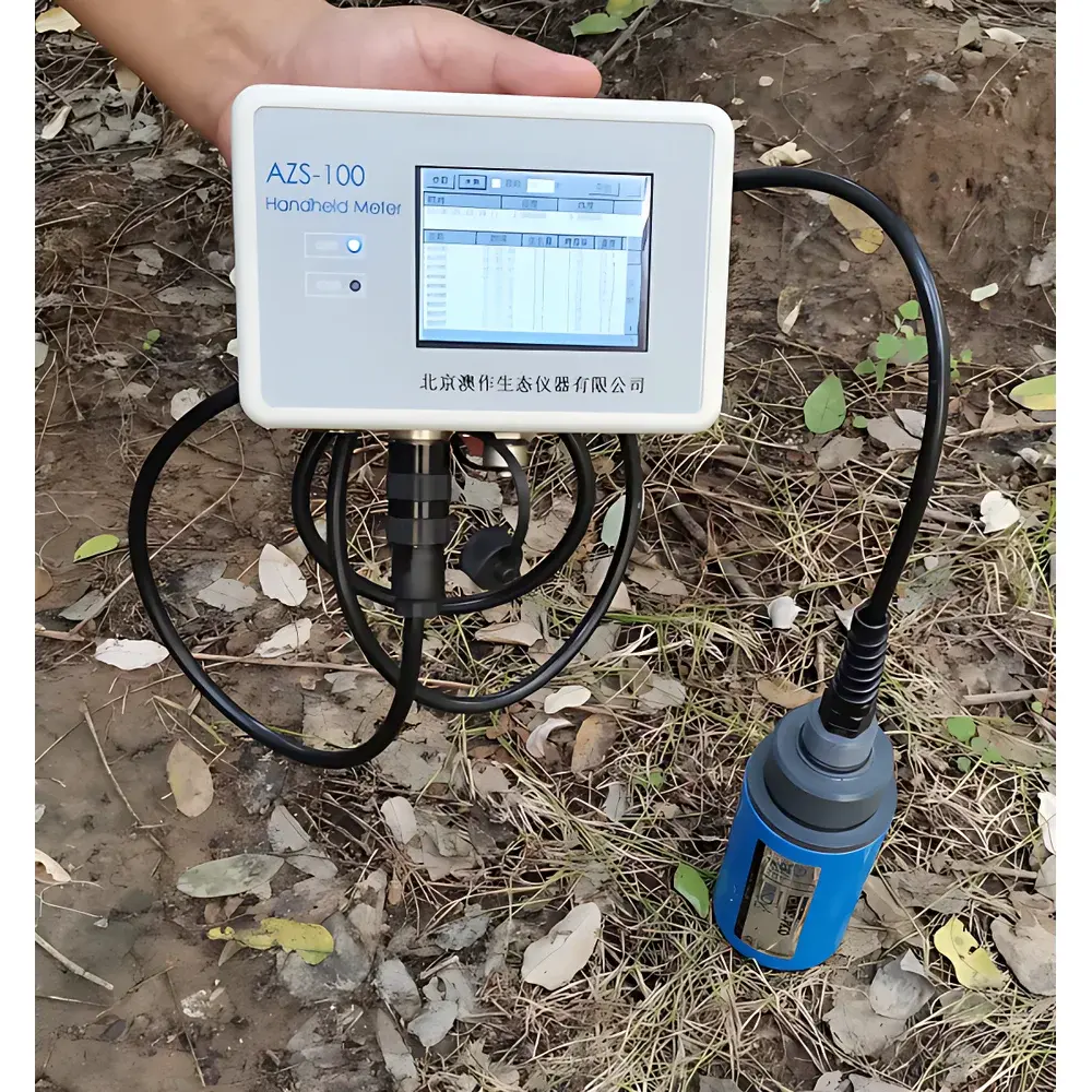
| Display | 3.5″ High-Brightness Backlit Touch LCD |
| Data Storage | 300,000+ records (expandable to 16 GB via SD card) |
| GPS | Integrated GNSS receiver (latitude/longitude logging) |
| Battery | 6000 mAh Li-ion, 12 h continuous operation |
| IP Rating | IP68 (sensor), IP65 (handheld unit) |
| Operating Temp | –15°C to +50°C |
| Output | Dual 0–1 V analog (4–20 mA optional), RS232 & TCP/IP connectivity |
| Software | Ecograph v4.x (Windows-based, GLP-compliant data management) |
Overview
The Ecograph Soil Moisture Surveyor is a field-deployable, GPS-integrated TDR (Time Domain Reflectometry)-based instrument engineered for high-reproducibility, real-time assessment of soil volumetric water content (θv), bulk electrical conductivity (ECa), and soil temperature. Designed for precision agriculture, environmental monitoring, and ecological research, it implements the physical principle that electromagnetic wave propagation velocity in soil is governed by its dielectric permittivity — a parameter dominantly controlled by water content. By generating and analyzing 1 GHz electromagnetic pulses along calibrated waveguide probes (e.g., TRIME-PICO64), the system directly computes θv from time-of-flight measurements with sub-nanosecond timing resolution. This eliminates empirical calibration drift common in capacitance-based sensors and ensures traceable, physics-based quantification across diverse soil textures — from sandy loam to clay-rich profiles.
Key Features
- TDR-based measurement architecture compliant with ASTM D5778 and ISO 11272 standards for soil water content determination.
- Integrated dual-channel analog output (0–1 V) supporting simultaneous θv and temperature transmission; 4–20 mA current loop option available for industrial SCADA integration.
- GNSS-enabled georeferencing: logs WGS84 latitude, longitude, and altitude with <5 m CEP (Circular Error Probable) under open-sky conditions; supports NMEA 0183 protocol output.
- 3.5-inch capacitive touch LCD with sunlight-readable backlight and intuitive icon-driven interface — operable with gloved hands in field conditions.
- Onboard non-volatile memory stores >300,000 timestamped records; expandable via removable microSD card (up to 16 GB) formatted as FAT32.
- Modular probe compatibility: certified for TRIME-PICO64 (64 cm³ measurement volume) and PICO32 sensors; all probes rated IP68 for long-term burial and immersion.
- Programmable auto-calibration recall: up to 15 user-defined soil-specific calibration curves stored internally and applied dynamically based on site ID or sensor serial number.
Sample Compatibility & Compliance
The Ecograph Surveyor accommodates heterogeneous soil matrices without mechanical disturbance: its 6 mm diameter stainless-steel waveguide probes minimize installation artifacts while ensuring robust signal coupling. Measurement validity spans θv = 0–100% (vol.) and ECa = 0–6 dS/m (standard range), with extended-range variants supporting up to 20 dS/m (requiring material-specific calibration). Temperature compensation is applied in real time using embedded Pt1000 thermistors (±1.5°C absolute accuracy). All hardware and firmware comply with IEC 61326-1 (EMC for laboratory and industrial use) and RoHS 2011/65/EU directives. Data integrity meets GLP requirements: audit trails, electronic signatures, and immutable timestamps are enforced in Ecograph software — fully compatible with FDA 21 CFR Part 11 readiness when deployed with validated IT infrastructure.
Software & Data Management
Ecograph v4.x is a Windows-native desktop application supporting both serial (RS232) and Ethernet (TCP/IP) data ingestion from handheld units and networked sensor nodes. It performs automated temporal alignment of multi-parameter datasets (soil moisture, EC, temperature, GPS position), applies user-selected calibration models, and exports structured CSV/Excel files with metadata headers compliant with FAO’s WaPOR database schema. Visualization tools include dual-Y-axis time-series plots, spatial heatmaps (KML export), and cross-parameter scatter analysis (e.g., θv vs. ECa). The software integrates with third-party ecological modules: vegetation indices (NDVI, RVI, EVI, SAVI, GSI) derived from co-located spectroradiometers, and carbon stock estimation workflows aligned with IPCC Tier 1 methodologies for soil organic carbon (SOC) and aboveground biomass quantification.
Applications
- Irrigation scheduling and deficit irrigation optimization in orchards, vineyards, and row-crop systems.
- Soil salinity mapping and drainage efficacy assessment in reclaimed arid-zone farmland.
- Long-term ecohydrological monitoring in LTER (Long-Term Ecological Research) sites and critical zone observatories.
- Validation of satellite-derived soil moisture products (e.g., SMAP, Sentinel-1) at field scale.
- Regulatory compliance reporting for EU Nitrates Directive and US EPA NPDES stormwater permits requiring soil moisture–nutrient leaching correlation data.
- Calibration reference for distributed fiber-optic DTS (distributed temperature sensing) soil moisture inversion models.
FAQ
What is the recommended probe insertion depth for optimal TDR measurement accuracy?
For TRIME-PICO64, full insertion to the 160 mm probe length is required to ensure representative sampling of the 1.25 L cylindrical measurement volume; shallow insertion (<120 mm) introduces air-gap artifacts and underestimates θv.
Can the Ecograph system operate unattended for extended periods?
Yes — when paired with external power (7–24 V DC) and a weatherproof enclosure, the handheld unit functions as a fixed-node data logger; internal battery is intended for mobile surveying only.
Is soil-specific calibration mandatory for scientific-grade data?
While factory-standard calibration covers ~85% of mineral soils, peer-reviewed publications require site-specific calibration per ISO 11272 Annex B for publication-grade uncertainty budgets (<±0.8% θv RMSE).
Does Ecograph software support automated report generation for regulatory submissions?
Yes — customizable templates generate PDF reports with embedded metadata, QA/QC flags, calibration certificates, and signature fields compliant with ISO/IEC 17025 documentation requirements.
How does the system handle high-salinity soils where EC exceeds 6 dS/m?
At EC >6 dS/m, TDR signal attenuation increases; users must select the extended-range calibration mode and validate against gravimetric samples — accuracy degrades to ±2–3% θv above 20 dS/m without custom dielectric mixing model input.
Related Products