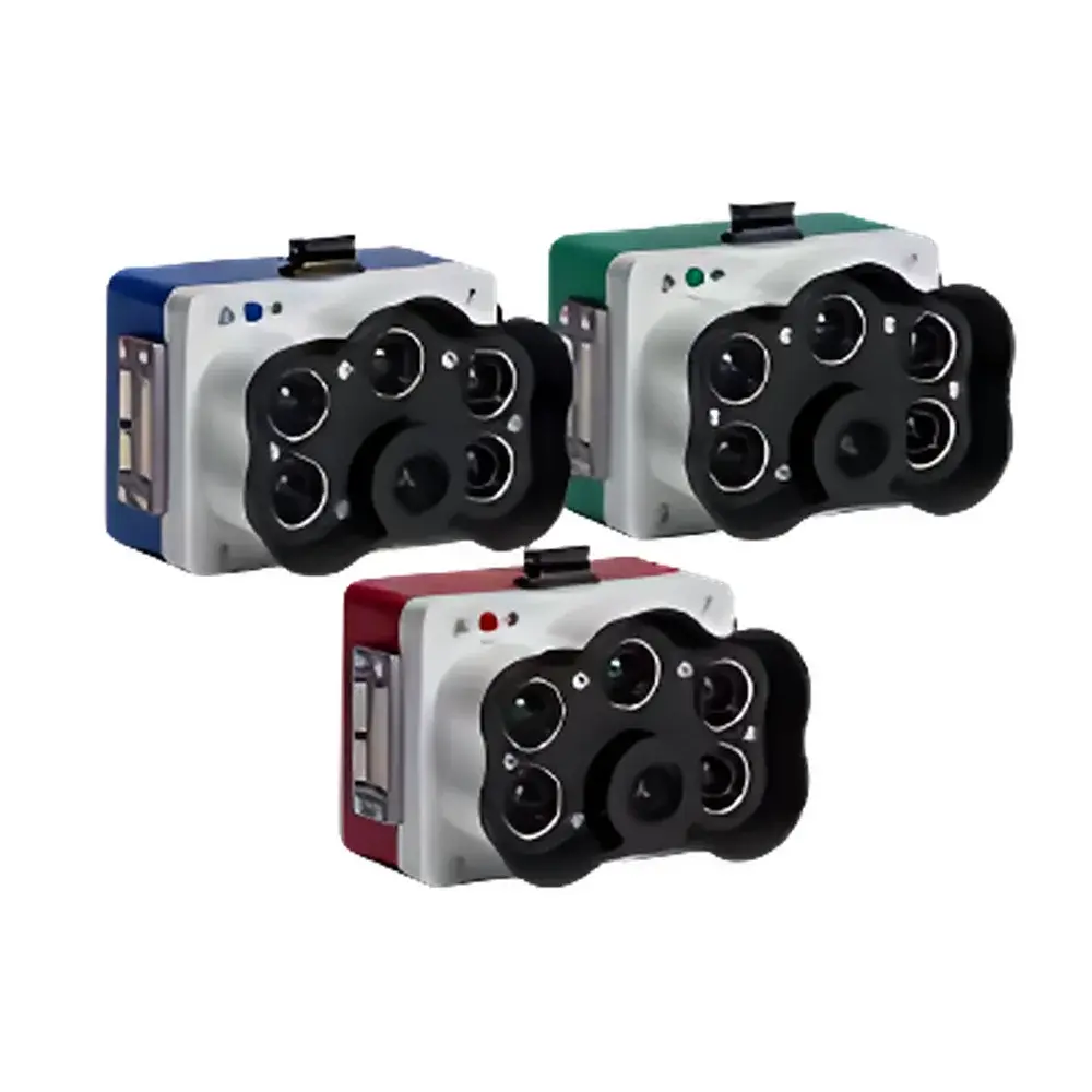
Micasense RedEdge-P Blue/Green Dual Multispectral Imaging System
| Brand | Micasense |
|---|---|
| Origin | USA |
| Manufacturer Type | Authorized Distributor |
| Product Origin | Imported |
| Model | RedEdge-P Blue/Green Dual Multispectral Camera System |
| Price Range | USD 17,500 – 21,700 (based on exchange rate and landed cost) |
| Spectral Bands | 10 total (5 per camera) |
| Panchromatic Resolution | 5.1 MP (2464 × 2056) |
| Multispectral Resolution | 1.6 MP per band (1456 × 1088) |
| GSD @ 120 m | 3.98 cm (panchromatic), 7.7 cm (multispectral) |
| FOV | 50° H × 38° V (MS), 44° H × 38° V (PAN) |
| Frame Rate | 3 fps |
| Calibration | Factory radiometric calibration + DLS2 downwelling irradiance sensor + CRP2 reflectance panel support |
| Interfaces | Gigabit Ethernet, USB 2.0 (Wi-Fi module), RS-232 serial, 3 configurable GPIO (trigger in, PPS in/out, pulse out) |
| Mounting | SkyPort-compatible for DJI enterprise drones |
Overview
The Micasense RedEdge-P Blue/Green Dual Multispectral Imaging System is a high-precision, dual-camera remote sensing platform engineered for ecological monitoring, precision agriculture, and environmental science applications requiring synchronized, co-registered spectral data across complementary band sets. Unlike single-sensor multispectral imagers, this system integrates two independently calibrated RedEdge-P cameras — one configured with the Blue-optimized spectral filter set (coastal blue, green, red, red-edge ×2), and the other with the Green-optimized set (cyan, green, yellow, red, NIR) — enabling simultaneous acquisition of 10 discrete, narrowband spectral channels (FWHM ≤ 28 nm) plus a 5.1 MP panchromatic band. The dual-camera architecture leverages spatially aligned optical paths and hardware-synchronized triggering to eliminate inter-frame misregistration, ensuring pixel-level consistency essential for time-series analysis, change detection, and vegetation index derivation. Measurement principle is based on push-broom–compatible snapshot imaging using scientific-grade CMOS sensors with factory-applied radiometric calibration traceable to NIST standards. Data output conforms to FAO-recommended radiometric units (W·m⁻²·sr⁻¹·nm⁻¹), supporting quantitative reflectance modeling when paired with the DLS2 irradiance sensor and CRP2 calibrated reflectance panel.
Key Features
- Dual-camera synchronization: Hardware-triggered, sub-millisecond timing alignment between Blue and Green variants ensures geometric and temporal co-registration without post-processing interpolation.
- Panchromatic sharpening: 5.1 MP panchromatic band (2464 × 2056) enables resolution enhancement of multispectral bands from native 1.6 MP (1456 × 1088) to effective 5.1 MP via constrained pan-sharpening algorithms compliant with ISO 19130-2 geospatial metadata standards.
- Field-deployable calibration ecosystem: Integrated DLS2 downwelling light sensor provides real-time irradiance measurement; CRP2 reflectance panel enables empirical normalization for cross-flight and cross-seasonal data comparability under variable illumination conditions.
- Robust mechanical design: IP64-rated enclosure with thermal management optimized for sustained operation at ambient temperatures ranging from −10°C to +50°C; compatible with DJI Matrice 300 RTK, M350 RTK, and Phantom 4 RTK via SkyPort interface.
- Dedicated spectral coverage: Blue variant covers coastal aerosol (444 nm), green (531 nm), red (650 nm), and dual red-edge bands (705 nm, 740 nm); Green variant includes cyan (502 nm), green (550 nm), yellow (570 nm), red (678 nm), and NIR (754 nm) — collectively aligning with Landsat-8 OLI, Sentinel-2 MSI, and MODIS band centers for satellite validation workflows.
Sample Compatibility & Compliance
The RedEdge-P Blue/Green Dual system is designed for aerial deployment on certified UAS platforms operating within Class 1/Class 2 BVLOS regulatory frameworks (FAA Part 107, EASA UAS Open Category). All spectral data products comply with ISO 19115-2 metadata schemas and include embedded geotags (WGS84), radiometric calibration coefficients, exposure parameters, and DLS2-measured irradiance values. Radiometric accuracy is validated per ASTM E2597-17 (Standard Practice for Calibration of Surface Temperature Measurement Systems Using Infrared Thermography) adapted for reflected solar radiation. The system supports GLP-compliant field data acquisition through audit-trail-enabled logging of sensor status, GPS timestamps, and environmental parameters — critical for environmental impact assessments submitted to EPA, USDA-NRCS, or EU Copernicus program partners.
Software & Data Management
Data capture and preprocessing are managed via Micasense’s proprietary AgVault desktop application and cloud-based FieldAgent platform. Raw .tif sequences are processed into orthomosaic-ready reflectance maps using proprietary radiometric correction pipelines that incorporate DLS2 irradiance scaling, vignetting compensation, and temperature-dependent dark current subtraction. Output formats include GeoTIFF with embedded RPCs, ENVI-compatible .hdr files, and CSV-based vegetation index tables (GNDVI, MTCI, PSRI, PRI, CRI, SIPI, NDVI, EVI). Integration with QGIS, ArcGIS Pro, and Google Earth Engine is supported via standardized GDAL drivers. Firmware updates and sensor diagnostics are performed over Gigabit Ethernet or Wi-Fi; all configuration changes are logged with ISO 8601 timestamps and user authentication tokens — satisfying FDA 21 CFR Part 11 requirements for electronic records where applicable.
Applications
- Precision agriculture: High-resolution chlorophyll absorption depth mapping using dual red-edge bands (705/740 nm) to quantify nitrogen stress and photosynthetic efficiency across heterogeneous fields.
- Coastal zone monitoring: Coastal blue (444 nm) and green (531 nm) bands enable suspended sediment concentration estimation and seagrass canopy discrimination in turbid waters.
- Forest health assessment: Yellow (570 nm) and red-edge (705 nm) response ratios detect early-stage foliar damage from pests, drought, or ozone exposure prior to visible symptom onset.
- Wetland classification: Joint analysis of cyan (502 nm), green (550 nm), and NIR (754 nm) improves separation of emergent macrophytes (e.g., Phragmites vs. Typha) in multi-temporal wetland inventories.
- Satellite validation: Band-to-band matching with Sentinel-2 MSI allows for vicarious calibration of Level-2A surface reflectance products over homogeneous calibration sites (e.g., Railroad Valley Playa, Libya-4).
FAQ
Does the RedEdge-P Blue/Green Dual system require external GNSS/IMU integration for georeferencing?
No — each camera embeds a high-accuracy u-blox F9P GNSS receiver and Bosch BMI088 IMU, delivering RTK-grade positioning (≤ 2 cm horizontal) and attitude data (roll/pitch/yaw ± 0.1°) directly within image EXIF metadata.
Can the two cameras be operated independently, or must they be triggered simultaneously?
Hardware synchronization is mandatory for co-registration integrity; independent operation is not supported in production firmware. Trigger logic is managed via GPIO or MAVLink commands issued from the host drone autopilot.
Is radiometric calibration valid across different flight altitudes and lighting conditions?
Yes — factory calibration is sensor-specific and wavelength-dependent. Real-time correction using DLS2 irradiance measurements and CRP2 reference panels maintains absolute reflectance accuracy across varying solar zenith angles and atmospheric conditions.
What spectral indices are natively computed in AgVault software?
AgVault computes 12 standard indices including GNDVI, MTCI, PSRI, PRI, CRI, SIPI, NDVI, EVI, SAVI, NDRE, OSAVI, and MCARI — all derived from atmospherically corrected reflectance layers with optional cloud masking.
How is long-term data stability ensured for multi-year monitoring programs?
Each sensor undergoes annual recalibration verification against NIST-traceable standards; firmware logs include sensor degradation metrics (dark current drift, gain shift) enabling proactive replacement before performance thresholds are exceeded.