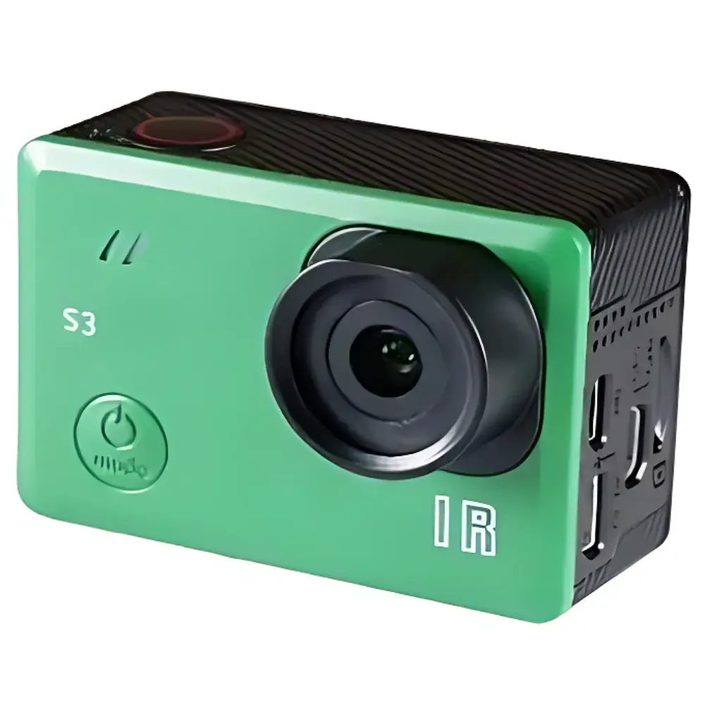
S3 Compact Airborne Multispectral Imager
| Origin | USA |
|---|---|
| Manufacturer Type | Distributor |
| Origin Category | Imported |
| Model | S3 |
| Price Range | USD 65,000–130,000 |
| Operating Principle | Filter-Based |
| Imaging Method | Filter-Based |
| Deployment Mode | Airborne |
| Image Resolution | 12 Megapixel (4000 × 3000 px) |
| Sensor Size | 6.20 × 4.65 mm |
| Pixel Pitch | 1.55 µm |
| Image Format | RAW (12-bit) + JPG (8-bit) |
| Lens Options | S3W (87° HFOV, f/3.0, 19 mm equiv.) or S3N (41° HFOV, 2× optical fixed zoom, f/3.0, 19 mm equiv.) |
| Distortion | <1% extreme low distortion (non-fisheye) |
| Focal Length | 8.25 mm |
| Ground Sampling Distance (GSD) | 2.3 cm/px at 120 m AGL |
| Capture Interval | 1.5 s (JPG), 2.75 s (RAW+JPG) |
| Trigger Interface | PWM via HDMI port |
| Storage | MicroSD (64 GB or 128 GB) |
| Weight | 50 g (body only), 76 g (with battery) |
| Dimensions | 59 × 41.5 × 36 mm (L × H × W) |
| Power Input | 5.2 V, 0.2 A (USB-powered), 5.2 V, 0.4 A (battery-powered) |
| Battery | Removable Li-ion, 1200 mAh |
| Display | 2.0″ ultra-bright color touchscreen LCD |
| Video Output | HD 1080p (HDMI micro), SD 480p (optional USB FPV cable) |
| Exposure Control | Auto, manual shutter (1/2000–60 s), ISO 50–400, exposure compensation ±2.0 in 1/3-stop increments |
| White Balance Modes | Auto, Daylight, Cloudy, Tungsten, Fluorescent, Blue, Light Blue, Red, Light Red, Custom |
| Color Profiles | Normal, B&W, Sepia, Vivid |
| Sharpness | Strong, Medium, Soft |
| Shooting Modes | Single, 3-sequence, 10-sequence |
| OSD | On/Off |
| Date Stamp | On/Off |
| Audio | On/Off |
| Quick Capture | On/Off |
| Auto Power-Off | Off, 1/3/5/10/15/30/60 min |
| LCD Sleep Timer | 1/3/5 min, Off |
| Vertical Flip | On/Off |
| Included Accessories | USB GPS receiver, battery, lens cap, USB charge cable, user manual |
Overview
The S3 Compact Airborne Multispectral Imager is an engineered solution for high-fidelity, lightweight remote sensing on small unmanned aerial systems (UAS). Designed for precision agriculture, environmental monitoring, and ecological research, the S3 operates on a filter-based multispectral acquisition principle—utilizing discrete bandpass interference filters to isolate spectral bands at defined center wavelengths and full-width half-maximum (FWHM) bandwidths. Unlike push-broom or line-scan hyperspectral systems, the S3 captures full-frame, georeferenced multispectral images simultaneously across up to four spectral channels using a single CMOS sensor with synchronized mechanical filter wheel actuation. Its 12-megapixel resolution (4000 × 3000 px), combined with a non-fisheye optical architecture (<1% geometric distortion), ensures pixel-level spatial fidelity required for quantitative reflectance analysis and orthomosaic generation. Integrated GPS synchronization enables automatic geotagging of every frame at sub-meter accuracy, supporting seamless integration into photogrammetric workflows compliant with ASPRS accuracy standards.
Key Features
- Lightweight airborne design: 50 g bare unit; 76 g with integrated Li-ion battery—optimized for Class I UAS platforms including DJI Mavic Pro, Phantom 4, and Inspire X3 series.
- Dual-field-of-view optical system: Interchangeable S3W (87° HFOV) and S3N (41° HFOV, 2× optical fixed zoom) lenses—both f/3.0, 8.25 mm focal length, with extreme low-distortion correction ensuring minimal radiometric and geometric error propagation.
- Configurable spectral channel sets: S3-RGN (660 nm R / 550 nm G / 850 nm NIR), S3-OCN (615 nm O / 490 nm BG / 808 nm NIR), S3-NGB (850 nm NIR / 550 nm G / 450 nm B), and S3-NIR (725 nm or 850 nm)—all calibrated to NIST-traceable spectral responsivity curves.
- Dual-format capture: Simultaneous 12-bit RAW + 8-bit JPG output supports both post-processing radiometric calibration (e.g., empirical line method, dark current subtraction) and rapid field visualization.
- Flexible triggering: Hardware-level PWM signal input via HDMI port enables precise synchronization with flight controller telemetry (e.g., position, altitude, heading) and external sensors—critical for time-critical surveys and repeat-pass change detection.
- Onboard 2.0″ ultra-bright touchscreen LCD with real-time histogram, exposure preview, and GPS status—enabling in-flight verification without ground station dependency.
Sample Compatibility & Compliance
The S3 is designed for outdoor, daylight-active remote sensing applications where spectral consistency, spatial registration, and operational robustness are paramount. It complies with ISO 18436-3 for condition monitoring equipment and meets electromagnetic compatibility (EMC) requirements per FCC Part 15 Subpart B and CE RED Directive 2014/53/EU. While not certified for medical or pharmaceutical use, its spectral channel configurations align with USDA-ARS and FAO-recommended band placements for vegetation indices—including NDVI, GNDVI, OSAVI, CVI, and ENDVI—ensuring comparability with legacy satellite and airborne datasets. The device supports GLP-aligned data provenance through embedded EXIF metadata (GPS coordinates, UTC timestamp, exposure parameters, firmware version) and optional external GPS logging for audit-ready traceability.
Software & Data Management
The S3 generates standard-compliant DNG (Digital Negative) files alongside JPEG previews, enabling interoperability with industry-standard photogrammetry and spectral analysis toolchains—including Pix4Dmapper, Agisoft Metashape, ENVI, QGIS with Semi-Automatic Classification Plugin (SCP), and Python-based libraries (e.g., rasterio, scikit-image, Py6S). Firmware updates are delivered via MicroSD card or USB interface, with versioned changelogs archived for regulatory documentation. No proprietary cloud platform is required; all raw data remains under user control. Optional SDK access provides programmatic control over exposure, white balance, and trigger logic—facilitating custom automation scripts compatible with ROS 2 and MAVLink telemetry protocols.
Applications
- Precision agriculture: In-season crop health assessment, nitrogen-use efficiency mapping, irrigation scheduling, and yield prediction via time-series NDVI and red-edge index trends.
- Ecological restoration: Post-fire vegetation recovery monitoring, invasive species detection, and wetland delineation using NIR–blue ratio thresholds.
- Forestry management: Canopy density estimation, species classification (via NGB configuration), and stress-induced chlorophyll fluorescence proxy detection.
- Environmental compliance: Mine reclamation progress tracking, landfill leachate plume identification, and coastal sediment transport modeling.
- Academic research: Field validation of Sentinel-2 and Landsat surface reflectance products, UAV-based radiative transfer model parameterization, and spectral library development.
FAQ
Is the S3 compatible with non-DJI drones?
Yes—the S3 mounts via standardized M3 threaded interfaces and supports generic PWM trigger inputs. Integration with PX4- or ArduPilot-based platforms requires custom servo rail mapping and telemetry passthrough configuration.
Does the S3 support radiometric calibration?
Yes—each unit ships with factory-acquired dark frame and flat-field reference data. Users may perform in-field calibration using Spectralon® panels or calibrated tarps following ASTM E275-21 procedures.
Can spectral bands be changed in the field?
No—optical filter sets are hardware-integrated and not user-swappable. Channel selection must be specified at time of order (e.g., S3-RGN or S3-NGB).
What GPS accuracy can be expected?
With the included USB GPS receiver (u-blox M8N), horizontal accuracy is ≤2.5 m CEP under open-sky conditions. RTK or PPK post-processing improves this to ≤5 cm when paired with base station data.
Is FDA 21 CFR Part 11 compliance supported?
The S3 itself does not implement electronic signature or audit trail features. However, its immutable EXIF metadata and RAW file integrity enable integration into validated LIMS or ELN environments that enforce Part 11 controls at the enterprise software layer.