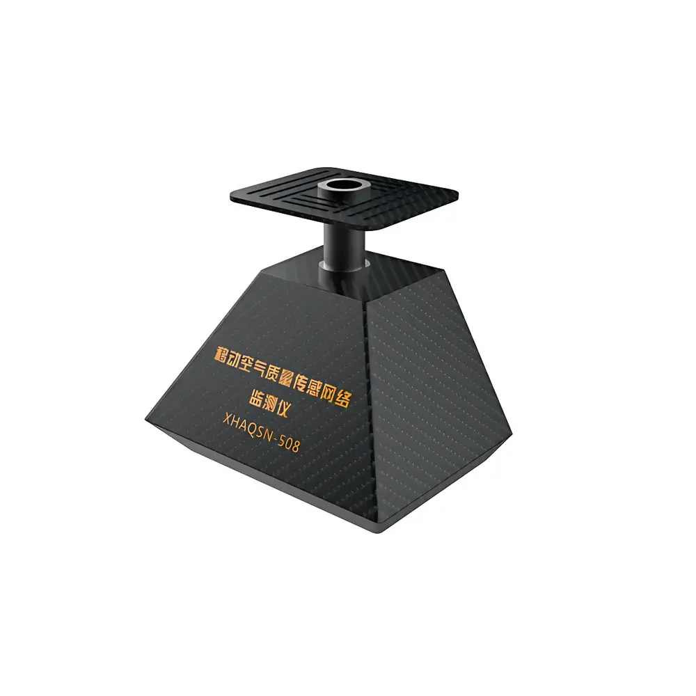
SAIL HERO XHAQSN-508 Mobile Air Quality Sensing Network Monitor
| Brand | SAIL HERO |
|---|---|
| Origin | Hebei, China |
| Manufacturer Type | OEM/ODM Producer |
| Country of Origin | China |
| Model | XHAQSN-508 |
| Instrument Type | Portable Ambient Air Quality Monitor |
| Measurable Parameters | PM₁₀, PM₂.₅, SO₂, NO₂, O₃, CO, Temperature, Relative Humidity |
| Sampling Method | Pump-aspirated |
| Weight | ≤1 kg |
| Power Supply | Integrated Rechargeable Lithium Battery (Operating Time >3 h on Full Charge) |
| Data Logging Interval | As Low as 1 s |
| Geotagging | GPS Coordinates + Altitude Embedded in Each Data Packet |
| Enclosure Material | Carbon Fiber Composite |
| Design Profile | Aerodynamic, Low-Drag Form Factor |
Overview
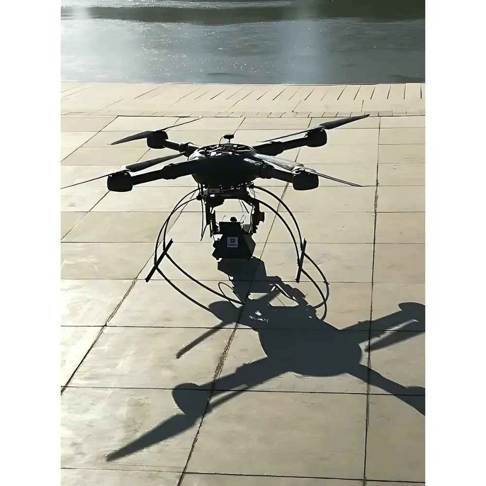
The SAIL HERO XHAQSN-508 Mobile Air Quality Sensing Network Monitor is an engineered solution for high-resolution, spatially distributed ambient air quality assessment. Designed around a pump-aspirated sampling architecture, it enables real-time, location-tagged measurement of key regulatory and health-relevant pollutants—including particulate matter (PM₁₀ and PM₂.₅), sulfur dioxide (SO₂), nitrogen dioxide (NO₂), ozone (O₃), carbon monoxide (CO), ambient temperature, and relative humidity. Its compact form factor and aerodynamic carbon fiber housing are optimized for dynamic deployment platforms: unmanned aerial vehicles (UAVs), municipal transit fleets (e.g., buses and taxis), and mobile ground-based inspection units. Unlike fixed-station monitors, the XHAQSN-508 supports adaptive monitoring strategies—enabling rapid response to pollution episodes, high-temporal-resolution mapping of traffic-related emissions, and validation of dispersion model outputs across heterogeneous urban microenvironments.
Key Features
- Pump-aspirated sampling system ensures consistent volumetric flow control and minimizes particle loss or gas adsorption artifacts—critical for reproducible quantification of both gaseous and aerosol-phase pollutants.
- Ultra-lightweight design (≤1 kg) with carbon fiber composite enclosure provides mechanical robustness while maintaining low aerodynamic drag—validated for stable UAV integration at flight speeds up to 12 m/s.
- Integrated GPS module records geospatial metadata (latitude, longitude, altitude) with every sensor reading, enabling precise spatiotemporal alignment of concentration data to road networks, land-use zones, or emission inventories.
- High-frequency data acquisition capability (minimum logging interval: 1 second) supports transient event capture—such as plume passage, cold-start vehicle emissions, or localized industrial fugitive releases.
- Onboard rechargeable lithium battery delivers >3 hours of continuous operation under typical environmental conditions (25°C, 50% RH), with power management firmware supporting sleep/wake cycles to extend field mission duration.
- Modular sensor architecture allows for future calibration traceability to NIST-traceable reference standards and facilitates periodic sensor replacement without full-system recalibration.
Sample Compatibility & Compliance
The XHAQSN-508 is designed for ambient air sampling in accordance with internationally recognized measurement principles. PM sensors operate via laser scattering (ISO 25242:2021 compliant optical detection), while electrochemical cells for SO₂, NO₂, CO, and O₃ meet performance criteria outlined in EN 14625 and EPA EQOA-001 specifications. Temperature and humidity sensing adheres to ISO 7726 ergonomic and environmental measurement standards. Though not certified as a reference-grade monitor per EU Directive 2008/50/EC Annex VI, the instrument is validated for indicative monitoring, source attribution studies, and exposure assessment applications where spatial density and mobility outweigh absolute metrological equivalence. Data output formats support interoperability with national air quality management systems compliant with China’s HJ 653–2013 technical specification and align with WHO Global Air Quality Guidelines (2021) reporting conventions.
Software & Data Management
Data from the XHAQSN-508 is transmitted via embedded 4G LTE or optional LoRaWAN modules to a secure cloud platform accessible through role-based web interfaces and RESTful APIs. Raw telemetry includes timestamp, GPS coordinates (WGS84), elevation (barometrically corrected), and calibrated sensor values with uncertainty estimates derived from onboard thermal drift compensation algorithms. The platform supports automated QA/QC flagging (e.g., out-of-range readings, sensor saturation, low-battery alerts), batch export in CSV/NetCDF formats, and GIS-integrated visualization layers. Audit trails comply with GLP-aligned data integrity requirements, including immutable timestamps, user-access logs, and version-controlled firmware updates—facilitating traceability in regulatory reporting contexts.
Applications
- Urban traffic emission profiling: Mounted on public transport fleets to generate high-density NOₓ and PM maps correlated with speed, acceleration, and road grade.
- Emergency response: Rapid UAV-deployed surveys during industrial accidents, wildfire smoke events, or hazardous material spills to define exposure boundaries.
- Policy evaluation: Long-term mobile monitoring before/after low-emission zone implementation to quantify changes in roadside pollutant gradients.
- School and residential exposure assessment: Pedestrian-level measurements near sensitive receptors to inform local mitigation strategies.
- Model validation: Ground-truthing of CFD or CALPUFF dispersion simulations using spatially resolved, time-synchronized datasets.
FAQ
What is the recommended calibration frequency for the XHAQSN-508?
Field calibration is advised every 30 days for gaseous sensors and every 60 days for PM modules when deployed in high-humidity or high-pollution environments; factory recalibration is recommended annually.
Can the device operate in extreme temperatures?
The operational range is −10°C to +50°C; extended cold-weather performance requires optional thermal stabilization accessories.
Is raw sensor data accessible via API?
Yes—full telemetry stream, including uncorrected analog outputs and diagnostic registers, is available through authenticated HTTPS API endpoints.
Does the system support remote firmware updates?
Yes, over-the-air (OTA) updates are supported with cryptographic signature verification and rollback capability.
How is data security ensured during transmission?
All communications use TLS 1.2+ encryption; device authentication employs X.509 certificates, and stored data is AES-256 encrypted at rest.