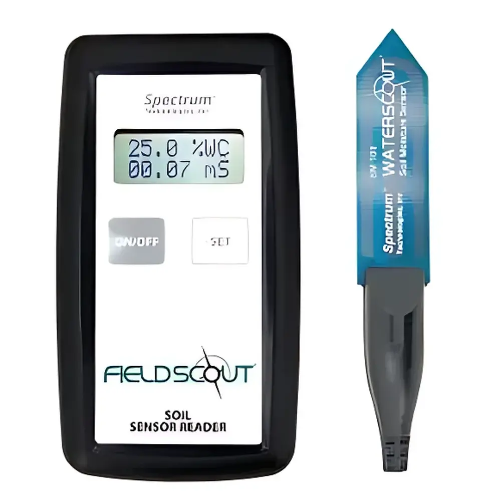
Spectrum SM100 Soil Moisture Monitor
| Brand | Spectrum Technologies |
|---|---|
| Origin | USA |
| Model | SM100 |
| Instrument Type | Volumetric Water Content (VWC) and Relative Water Content (RWC) Monitor |
| Measurement Principle | Time-Domain Reflectometry (TDR) |
| Range | 0–Saturation (v/v) |
| Accuracy | ±3.0% (for EC < 2 dS/m and clay content < 30%) |
| Resolution | 1.0% |
| Data Storage | 2,700 readings (1,250 with GPS enabled) |
| Power | 4 × AAA alkaline batteries |
| Battery Life | ~12 months typical usage |
| Weight | 1.36 kg |
| Probe Dimensions | 10.41 cm × 7.11 cm × 1.78 cm |
| Reader Dimensions | 10.5 cm × 7.0 cm × 1.8 cm |
| Probe Needle Diameter | 0.5 cm |
| Inter-needle Spacing | 3.3 cm |
| Probe Insertion Profile | Low-disturbance, tapered tip design for minimal root disruption |
Overview
The Spectrum SM100 Soil Moisture Monitor is a field-deployable, TDR-based (Time-Domain Reflectometry) instrument engineered for high-reproducibility volumetric water content (VWC) and relative water content (RWC) measurements in situ. Unlike single-point handheld meters limited to instantaneous spot readings, the SM100 supports longitudinal soil moisture profiling through programmable, time-synchronized deployments across multiple units—enabling robust temporal resolution of soil water dynamics without requiring continuous manual intervention. Its TDR measurement principle relies on electromagnetic pulse propagation along parallel stainless-steel probes; dielectric permittivity of the surrounding medium is derived from signal reflection timing, which correlates directly with volumetric water content under calibrated soil-specific conditions. The device operates independently of soil salinity up to 2 dS/m and remains accurate in soils with ≤30% clay content—making it suitable for agricultural research, ecological monitoring, irrigation scheduling validation, and pedological studies where long-term, low-impact sensor integration is required.
Key Features
- Low-disturbance probe geometry: Ultra-thin cross-section (1.78 cm thickness) and precision-tapered tip enable insertion into undisturbed soil profiles or growth media with negligible root system displacement—critical for longitudinal root-zone studies.
- Multi-unit synchronization capability: Units can be configured to log data at identical timestamps, supporting spatially distributed monitoring networks across experimental plots or field transects.
- Integrated data logging: Stores up to 2,700 VWC/RWC readings internally; storage capacity adjusts dynamically when GPS geotagging is enabled (1,250 entries).
- Field-portable architecture: Compact handheld reader (10.5 × 7.0 × 1.8 cm) and lightweight probe assembly (1.36 kg total) facilitate rapid deployment and repeated relocation without specialized tools.
- Robust power management: Operates on four standard AAA alkaline cells with an expected service life of approximately 12 months under typical seasonal sampling intervals (e.g., daily or bi-daily logging).
Sample Compatibility & Compliance
The SM100 is validated for use in mineral soils, potting mixes, peat-based substrates, and hydroponic growth media. Its TDR calibration accounts for bulk density and textural variability within defined limits (clay ≤30%, EC ≤2 dS/m), aligning with ASTM D5778 (Standard Test Method for Electronic Friction Cone and Piezocone Penetration Testing) and ISO 11274 (Soil Quality — Determination of Water Retention Characteristic). While not intrinsically compliant with FDA 21 CFR Part 11, raw data export (via USB or optional Bluetooth module) supports traceable laboratory workflows under GLP/GMP frameworks when paired with documented chain-of-custody protocols and version-controlled calibration logs.
Software & Data Management
Data retrieval is performed via direct USB connection to Windows-compatible PCs using Spectrum’s proprietary Loggernet-compatible software suite. Export formats include CSV and Excel (.xlsx), preserving timestamp, GPS coordinates (if enabled), VWC (% v/v), RWC (%), temperature (if equipped), and diagnostic flags (e.g., high-EC warning). The software supports batch processing of multi-sensor datasets, automated outlier detection based on user-defined thresholds, and generation of time-series plots with customizable axis scaling. Audit trails—including operator ID, firmware revision, and calibration date—are embedded in metadata headers to support regulatory documentation requirements.
Applications
- Agricultural water-use efficiency trials: Quantifying crop evapotranspiration responses to deficit irrigation regimes over growing seasons.
- Ecophysiological research: Correlating root-zone moisture gradients with stomatal conductance, xylem sap flow, and leaf water potential measurements.
- Soil hydrology modeling: Providing empirical boundary condition inputs for HYDRUS-1D or SWAP model parameterization.
- Green infrastructure monitoring: Tracking infiltration rates and retention capacity in bioswales, rain gardens, and permeable pavements.
- Undergraduate teaching labs: Supporting hands-on instruction in soil physics, environmental instrumentation, and experimental design principles with minimal setup overhead.
FAQ
Can the SM100 be left permanently installed in the field?
Yes—its sealed probe housing and corrosion-resistant stainless-steel electrodes are rated for continuous burial in non-aggressive soils. Long-term drift is minimized by factory calibration stability; annual verification against gravimetric samples is recommended.
Is soil-specific calibration required?
Factory calibration covers typical mineral soils. For organic-rich or highly saline media, a two-point (dry/saturated) gravimetric calibration is advised per ISO 11274 Annex B.
Does the SM100 measure soil water potential or matric potential?
No—it reports volumetric water content (VWC) and derived relative water content (RWC). For matric potential, pairing with a tensiometer or MPS-6 sensor is recommended.
What is the minimum measurable soil volume?
The effective sensing volume approximates a cylindrical zone ~10 cm in diameter and 5 cm in height centered on the probe axis—validated via neutron probe cross-comparison studies.
Can GPS data be disabled to maximize memory capacity?
Yes—disabling geotagging restores full 2,700-entry storage and reduces power consumption during logging cycles.
Related Products


