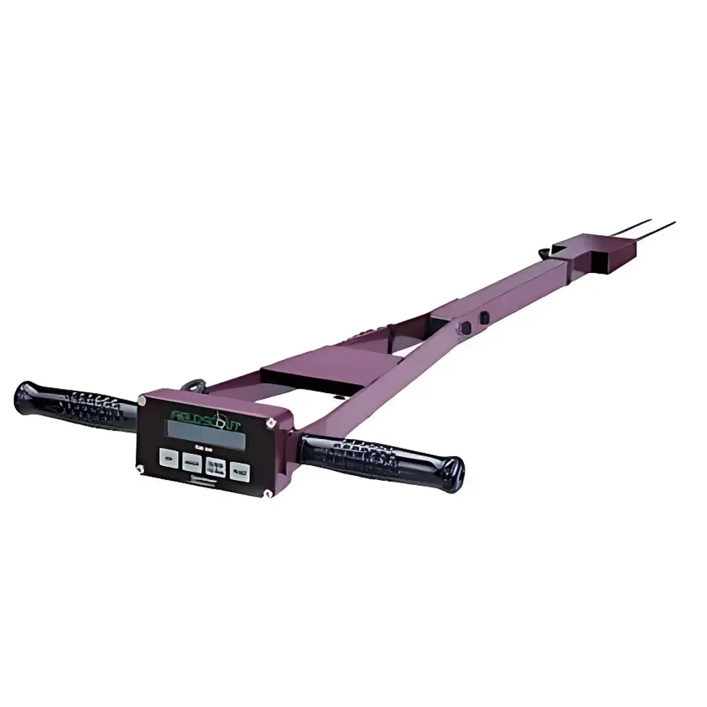
Spectrum Technologies TDR300 Portable Time-Domain Reflectometry Soil Moisture Analyzer
| Origin | USA |
|---|---|
| Manufacturer Type | Authorized Distributor |
| Origin Category | Imported |
| Model | TDR-300 |
| Instrument Type | Volumetric Water Content (VWC) and Relative Water Content (RWC) Analyzer |
| Probe Options | 7.5 cm, 12 cm, 20 cm stainless steel waveguide rods |
| Measurement Principle | Time-Domain Reflectometry (TDR) |
| Range | 0–saturation (volumetric water content) |
| Accuracy | ±3.0% (for EC < 2 dS/m and clay content < 30%) |
| Resolution | 1.0% VWC |
| Data Storage | 2,700 readings (1,250 with GPS synchronization) |
| Interface | RS-232 serial port |
| Power | 4 × AAA alkaline batteries (typical lifespan: 12 months) |
| Weight | 1.36 kg (instrument only) |
| Display Unit Dimensions | 10.5 × 7 × 1.8 cm |
| Probe Dimensions | 10.41 × 7.11 × 1.78 cm |
| Rod Diameter | 0.5 cm |
| Rod Spacing | 3.3 cm |
| Measurement Modes | Volumetric Water Content (VWC) and Relative Water Content (RWC) |
Overview
The Spectrum Technologies TDR300 Portable Time-Domain Reflectometry Soil Moisture Analyzer is a field-deployable, precision instrument engineered for direct in-situ measurement of volumetric water content (VWC) in mineral soils. It operates on the well-established principle of time-domain reflectometry (TDR), wherein a fast-rise electromagnetic pulse is propagated along parallel stainless-steel waveguide rods inserted into the soil; the travel time of the reflected signal is directly correlated to the dielectric permittivity of the surrounding medium, which—under typical agricultural and ecological conditions—is dominated by water content. Unlike capacitance-based sensors, TDR is minimally affected by soil salinity (up to 2 dS/m) and texture variation (valid for clay contents <30%), delivering high reproducibility without site-specific calibration. The TDR300 integrates a built-in data logger and RS-232 interface, enabling synchronized georeferenced sampling when paired with GPS or DGPS receivers—making it suitable for spatial soil moisture mapping, irrigation scheduling validation, and long-term environmental monitoring programs.
Key Features
- Integrated data acquisition system with non-volatile memory storing up to 2,700 VWC/RWC measurements (reduced to 1,250 when logging GPS coordinates)
- Dual-mode display: real-time volumetric water content (% v/v) and user-defined relative water content (RWC) for irrigation threshold management
- RS-232 serial interface compliant with standard PC communication protocols; supports ASCII output for direct import into spreadsheet, GIS, or LIMS environments
- Modular probe architecture: interchangeable stainless-steel rod probes (7.5 cm, 12 cm, and 20 cm lengths) optimized for shallow-rooted crops, deep-profile profiling, or layered soil analysis
- Rugged, weather-resistant housing rated for outdoor operation across –10°C to +50°C ambient conditions
- Low-power design powered by four standard AAA alkaline cells, delivering approximately 12 months of field use under typical sampling intervals (e.g., hourly logging)
Sample Compatibility & Compliance
The TDR300 is validated for use in mineral soils with electrical conductivity ≤2 dS/m and clay content ≤30%. It is not recommended for saturated peat, highly organic substrates (>60% OM), or soils containing metallic debris or coarse gravel (>2 cm diameter) that may disrupt electromagnetic wave propagation. Probe insertion requires minimal soil disturbance and no soil-specific calibration—consistent with ASTM D5778 (Standard Test Method for Electronic Friction Cone and Piezocone Penetration Testing) and ISO 11274 (Soil Quality — Determination of Water Retention Characteristic). While the instrument itself does not carry FDA or EPA certification, its measurement methodology aligns with USDA-NRCS soil hydrology protocols and supports GLP-compliant data collection when used with timestamped, GPS-tagged logging and audit-trail-enabled software.
Software & Data Management
Data retrieval is performed via RS-232 connection using Spectrum’s proprietary TDR Utility software (Windows-compatible), which enables batch download, unit conversion (e.g., VWC to matric potential via established pedotransfer functions), and export to CSV, Excel, or ESRI Shapefile formats. The software supports metadata tagging—including operator ID, site ID, probe depth, and soil classification codes—to ensure traceability. When interfaced with third-party platforms such as ArcGIS, QGIS, or R-based spatial analysis workflows, the TDR300’s georeferenced datasets support kriging interpolation, temporal trend analysis, and integration with evapotranspiration models (e.g., FAO-56 Penman-Monteith). All logged entries include UTC timestamps and optional GPS-derived WGS84 coordinates, satisfying basic requirements for ISO/IEC 17025 documentation integrity.
Applications
- Field-scale irrigation scheduling and deficit irrigation optimization in agronomic research and commercial farming
- Calibration and validation of remote sensing soil moisture products (e.g., SMAP, Sentinel-1 SAR backscatter)
- Long-term ecological monitoring in watersheds, wetlands, and restoration sites
- Greenhouse and growth chamber experiments requiring high-temporal-resolution soil water dynamics
- Soil physics education: demonstration of dielectric behavior, pore-water distribution, and hysteresis effects
- Pre-construction geotechnical assessment of near-surface moisture variability prior to foundation or pavement design
FAQ
What is the maximum soil electrical conductivity (EC) the TDR300 can reliably measure at?
The TDR300 maintains ±3.0% accuracy for soils with bulk EC ≤2 dS/m. Above this threshold, signal attenuation increases, and users should consider alternative methods such as neutron probe or calibrated capacitance sensors.
Can the TDR300 be used in frozen soils?
No. TDR signal propagation is severely impeded in ice-saturated matrices due to the dielectric contrast between liquid water (ε ≈ 80) and ice (ε ≈ 3.2); measurements below 0°C are not physically interpretable and are outside the instrument’s specified operating range.
Is probe calibration required before each use?
No factory or field recalibration is needed. The instrument employs factory-characterized TDR waveform analysis algorithms and assumes air (ε = 1) and distilled water (ε = 78.5) as reference endpoints—both embedded in firmware. Users must only verify mechanical probe integrity and rod alignment prior to insertion.
How does the TDR300 handle data synchronization with GPS devices?
It accepts NMEA 0183 GGA and RMC sentences over RS-232 at 4800 baud. Latitude, longitude, altitude, and UTC time are appended to each VWC reading during active GPS logging, enabling post-processing spatial interpolation.
What is the minimum recommended soil bulk density for accurate TDR300 readings?
While not a strict specification, optimal performance is observed at bulk densities between 1.2–1.6 g/cm³—typical of tilled agricultural soils. Compacted layers (>1.8 g/cm³) may cause minor underestimation due to reduced probe-soil contact area, and users should perform vertical profile comparisons to identify such anomalies.