Top Cloud-agri TZS-2X-G Soil Moisture and Temperature Profiler
| Brand | Top Cloud-agri |
|---|---|
| Origin | Zhejiang, China |
| Manufacturer Type | OEM/ODM Producer |
| Country of Origin | China |
| Model | TZS-2X-G |
| Instrument Type | Soil Moisture & Temperature Meter |
| Measurement Parameters | Soil Temperature (°C), Volumetric Water Content (%VWC) |
| Communication | 4G/5G Cellular + GPS + USB + Cloud API |
| Data Storage | 30,000 entries internal Flash + expandable microSD (up to 4GB default) |
| Power | Rechargeable 7.4V 2.8Ah Li-ion battery (with low-voltage warning & charge protection) |
| Operating Current | 10mA (standby), variable under active sensing |
| Sampling Interval | 5 min – 99 h |
| Display | Backlit Chinese LCD with real-time timestamp, sensor values, memory status, GPS coordinates |
| Sensor Interface | IP67-rated multi-sensor hub (up to 32 channels) |
| Compliance | Designed for field-deployed environmental monitoring per ISO 11274 (soil water retention), ASTM D5859 (in-situ soil moisture), and GLP-aligned data integrity practices |
Overview
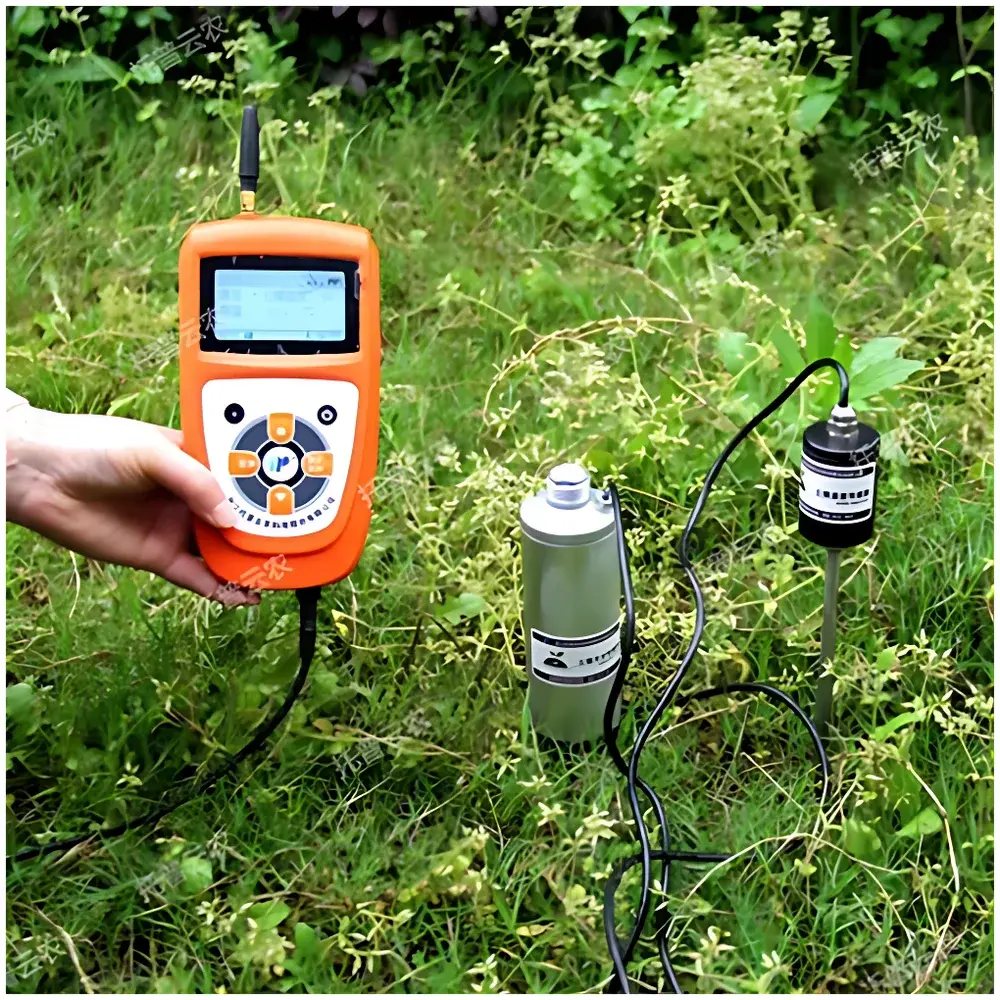
The Top Cloud-agri TZS-2X-G Soil Moisture and Temperature Profiler is a field-deployable, dual-parameter environmental sensor system engineered for high-reproducibility in-situ measurement of volumetric water content (%VWC) and soil temperature (°C). Based on calibrated capacitance-based dielectric sensing for moisture and precision thermistor-based detection for temperature, the instrument delivers traceable, physics-derived measurements compliant with standard soil physical characterization protocols. Its ruggedized handheld architecture integrates embedded GPS geotagging, cellular telemetry (4G/5G), and long-term autonomous operation—making it suitable for unattended deployment across heterogeneous terrain. Unlike laboratory-only benchtop analyzers, the TZS-2X-G bridges the gap between point-in-time field sampling and continuous environmental time-series acquisition, supporting both manual spot checks and scheduled remote monitoring workflows.
Key Features
- Dual-parameter real-time sensing: Simultaneous acquisition of soil temperature (−40 °C to +100 °C, ±0.5 °C accuracy, 0.1 °C resolution) and volumetric water content (0–100 %VWC, ≤3% relative error, 0.1 %VWC resolution, <2 s response time).
- Integrated GNSS positioning: Automatic embedding of WGS84 latitude/longitude coordinates into each data record for spatially referenced analysis.
- Multi-layer data storage architecture: 30,000-sample internal Flash buffer + removable microSD card (4 GB standard, scalable) enabling redundant local archiving.
- Low-power embedded design: 7.4 V / 2.8 Ah rechargeable lithium-ion battery with intelligent power management, standby current ≤10 mA, and configurable sleep/wake cycles.
- Modular sensor expansion: IP67-rated universal hub supports up to 32 analog/digital sensor inputs—including optional atmospheric temperature, RH, dew point, EC, or salinity modules—without cross-channel interference.
- Configurable human-machine interface: Backlit Chinese-language LCD displays timestamp, live sensor values, memory utilization, GPS fix status, and battery level; supports voice alerts (Chinese Mandarin) for threshold violations.
- Flexible acquisition modes: Manual trigger, programmable interval logging (5 minutes to 99 hours), and event-driven capture—all executable without PC connectivity.
Sample Compatibility & Compliance
The TZS-2X-G is validated for direct insertion into mineral soils, loams, sandy, and clay-rich substrates with minimal disturbance. Sensor probe length ≥25 cm ensures representative profile sampling in topsoil (0–20 cm depth range). Calibration adheres to empirical dielectric models consistent with USDA NRCS guidelines and ISO 11274 Annex B for field-moisture correlation. While not certified for regulatory submission under FDA 21 CFR Part 11, its audit-ready data structure—including immutable timestamps, GPS metadata, and device-specific identifiers—supports GLP-compliant field documentation when deployed within documented SOPs. Data export formats (CSV, Excel-compatible) facilitate integration into third-party LIMS or statistical analysis platforms.
Software & Data Management
The TZS-2X-G operates natively with the Top Cloud-agri Instrument Cloud Platform—a secure, browser-accessible SaaS environment supporting C/S and B/S architectures. All measurements upload automatically via encrypted 4G/5G transmission or manually via USB mass-storage mode. The platform provides role-based access control, versioned data backups, and full audit trails (user actions, upload timestamps, edit history). Analytical tools include temporal trend visualization (line/area charts), spatial heatmaps (via GIS overlay), customizable reporting templates, and batch export in CSV, PDF, or XLSX. Firmware updates are delivered over-the-air, ensuring sustained compatibility with evolving network standards and security patches. API endpoints support programmatic integration with enterprise environmental dashboards or IoT middleware (e.g., MQTT brokers).
Applications
- Irrigation scheduling and deficit irrigation optimization in precision agriculture;
- Soil hydrological modeling input for SWAT, HYDRUS, or MODFLOW calibration;
- Ecological monitoring of grassland, forest floor, and wetland moisture dynamics;
- Infrastructure health assessment: moisture-induced swelling/shrinkage monitoring beneath roads, railways, and embankments;
- Educational field labs requiring portable, curriculum-aligned instrumentation;
- Long-term climate observatory networks where low-maintenance, solar-extendable operation is critical.
FAQ
What is the recommended insertion depth for accurate soil moisture readings?
For optimal representativeness in agricultural contexts, insert the probe vertically to a minimum depth of 20 cm—ensuring full contact with undisturbed soil matrix and avoiding air gaps or surface crust interference.
Can the TZS-2X-G operate continuously for extended periods without manual intervention?
Yes—when configured with scheduled logging intervals and powered by its internal battery or an external 8.4 V DC supply, the unit supports unattended operation for up to 12 months depending on sampling frequency and network transmission load.
Is raw sensor calibration data accessible for traceability purposes?
Calibration coefficients and factory verification reports are embedded in device firmware and retrievable via diagnostic mode; users may request NIST-traceable calibration certificates from Top Cloud-agri upon purchase.
Does the cloud platform support multi-user collaboration and permission tiers?
Yes—the platform implements hierarchical user roles (admin, editor, viewer) with granular dataset-level permissions, enabling shared project management across research teams, extension services, or municipal agencies.
How does the system handle signal loss during cellular outages?
All unsent records remain buffered in non-volatile Flash memory and transmit automatically once network connectivity resumes—no data loss occurs due to transient disconnections.
Related Products


