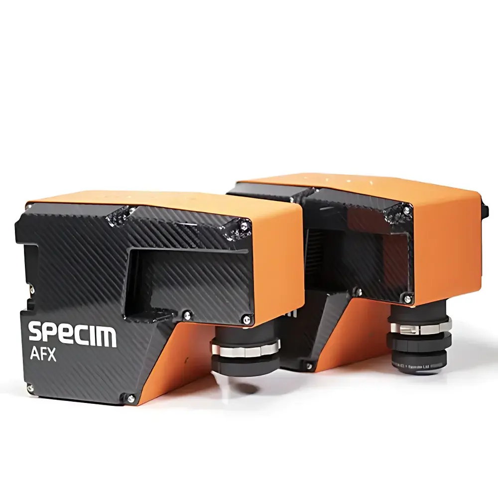
Specim AFX Series Airborne Hyperspectral Imaging System
| Brand | Specim (a Konica Minolta company) |
|---|---|
| Origin | Japan |
| Model | Specim AFX Series |
| Spectral Range | 400–1000 nm |
| Spectral Resolution | 5.5 nm |
| Platform Compatibility | UAV-mounted (multirotor & fixed-wing) and ground-based operation |
| Integration | Integrated GNSS/IMU, onboard computing unit, FX-series hyperspectral camera |
| Software Compatibility | Specim CaliGeo PRO, ENVI, PCI Geomatica, QGIS (with appropriate plugins) |
| Data Output Format | Radiometrically calibrated, georeferenced ENVI-compatible .hdr/.raw files |
Overview
The Specim AFX Series is a purpose-engineered airborne hyperspectral imaging system designed for high-fidelity remote sensing applications requiring spatially resolved spectral data across the visible to near-infrared (VNIR) range. Built upon Specim’s proven FX-series line-scan push-broom hyperspectral cameras, the AFX integrates a ruggedized embedded computer, a high-accuracy GNSS/IMU navigation unit, and optimized thermal and mechanical design—enabling stable, radiometrically consistent data acquisition from dynamic aerial platforms. Unlike conventional multispectral systems, the AFX captures contiguous spectral bands at 5.5 nm resolution over 400–1000 nm, enabling discrimination of subtle material properties—including pigment composition, moisture content, biochemical indicators, and surface reflectance anomalies—based on their unique spectral signatures. Its push-broom architecture ensures pixel-aligned spectral data cubes without spatial distortion, while synchronized GNSS/IMU telemetry enables direct georeferencing without post-mission ground control point (GCP) dependency in many operational scenarios.
Key Features
- Integrated Turnkey Architecture: Combines Specim FX-series VNIR imager, real-time onboard processing unit, and dual-antenna GNSS/IMU with RTK capability—eliminating external cabling, reducing integration time, and minimizing payload footprint.
- Platform-Agnostic Deployment: Certified for operation on multirotor UAVs (≥3 kg payload capacity), fixed-wing platforms (including VTOL), and terrestrial tripods; no gimbal required due to IMU-driven motion compensation and intrinsic geometric stability.
- Radiometric Calibration & Illumination Robustness: Factory-calibrated radiometric response with built-in dark current and flat-field correction; enhanced low-light performance via adaptive exposure control and image enhancement algorithms preserving SNR across varying solar zenith angles.
- Automated Mission Execution: Supports flight-plan-driven acquisition using industry-standard MAVLink protocols; triggers frame capture synchronously with position/attitude metadata, ensuring traceable spatiotemporal alignment of every spectral pixel.
- Thermal & Vibration Resilience: Operates continuously within −10 °C to +50 °C ambient range; mechanically decoupled optics and shock-isolated electronics meet MIL-STD-810G vibration and shock requirements for UAV deployment.
Sample Compatibility & Compliance
The AFX system does not require physical sample contact and is non-destructive by design. It acquires reflected solar radiation from natural or artificial surfaces—including vegetation canopies, soil substrates, mineral outcrops, agricultural fields, coastal zones, and man-made infrastructure. Its spectral fidelity supports compliance with established remote sensing validation frameworks, including NASA’s CEOS/WGCV protocols for sensor characterization and ESA’s Fiducial Reference Measurements (FRM) guidelines. While not certified to ISO/IEC 17025 as a laboratory instrument, its calibration traceability aligns with NIST-traceable standards for radiometric and geometric performance. The system’s metadata structure conforms to ISO 19115-2 and OGC SensorML specifications, facilitating interoperability in GEOINT and environmental monitoring workflows governed by INSPIRE or national geospatial data infrastructures.
Software & Data Management
Data output follows ENVI header (.hdr) and binary (.raw) conventions, containing full radiometric calibration coefficients, band centers, FWHM values, and per-pixel GNSS/IMU pose stamps. Specim CaliGeo PRO provides end-to-end processing: radiometric correction, orthorectification using DSM/DTM inputs, atmospheric compensation (via MODTRAN-based modeling), and generation of analysis-ready GeoTIFFs with UTM/WGS84 projection. The AFX SDK enables custom Python- or C++-based pipeline development, supporting integration into automated QA/QC workflows compliant with ISO 19156 (Observations & Measurements) and FAIR data principles. Exported datasets retain audit trails for GLP-aligned environmental reporting and are compatible with FDA 21 CFR Part 11–compliant electronic record systems when deployed with validated e-signature modules.
Applications
- Agricultural monitoring: Crop health assessment (NDVI, PRI, MCARI), nitrogen status mapping, disease detection, and yield prediction.
- Environmental science: Wetland delineation, invasive species identification, chlorophyll-a estimation in inland waters, and post-wildfire vegetation recovery analysis.
- Geological surveying: Lithological mapping, alteration mineral detection (e.g., clays, iron oxides), and mine waste characterization.
- Forestry: Species classification, canopy density modeling, and bark beetle infestation early warning.
- Urban remote sensing: Material classification (roofs, roads, façades), heat island analysis, and impervious surface quantification.
- Defense & security: Camouflage detection, concealed object identification, and change detection over time series.
FAQ
Is the AFX system suitable for regulatory-grade environmental reporting?
Yes—when operated with documented calibration logs, GNSS/IMU accuracy verification reports, and processed using validated CaliGeo PRO workflows, outputs meet evidentiary thresholds for submissions to agencies such as the US EPA, EU JRC, and national environmental protection authorities.
Can I process AFX data without Specim CaliGeo PRO?
Yes—data is delivered in open ENVI format and fully compatible with ENVI, ERDAS IMAGINE, PCI Geomatica, SNAP, and Python libraries (e.g., scikit-image, rasterio, hylite). However, radiometric and geometric corrections require accurate metadata ingestion, which CaliGeo PRO automates.
What GNSS/IMU performance level does the AFX integrate?
It incorporates a dual-frequency GNSS receiver with RTK support (horizontal accuracy ≤2 cm + 1 ppm, vertical ≤3 cm + 1 ppm) and a tactical-grade IMU (bias instability <5°/hr, angular random walk <0.15°/√hr), enabling direct georeferencing at sub-decimeter GSD under typical UAV flight conditions.
Does the system support real-time data streaming or onboard analytics?
No—the AFX records raw calibrated data to internal SSD storage for post-mission processing. Real-time transmission is not supported due to bandwidth constraints and radiometric integrity requirements; however, lightweight metadata telemetry (position, attitude, exposure settings) is logged synchronously for quality assurance.
How is radiometric calibration maintained across missions?
Each unit ships with factory-acquired dark current, flat-field, and spectral response curves. Users may perform optional field-based reference panel acquisitions (e.g., Spectralon®) to update illumination normalization; calibration coefficients are embedded in all output files for full traceability.
Related Products


")