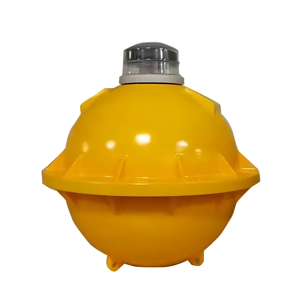
Langcheng LS-DB300MM Surface Drifting Buoy
| Origin | Guangdong, China |
|---|---|
| Manufacturer Type | Authorized Distributor |
| Origin Category | Domestic (China) |
| Model | LS-DB300MM |
| Price | USD 3,500 (FOB Shenzhen) |
| Positioning System | GPS/BeiDou Dual-Mode GNSS |
| Communication | BeiDou Short Message Service (BDS-SMS) |
| Power Supply | Rechargeable Lithium-Ion Battery (≥12,000 mAh) |
| Operational Lifetime | 30–240 days (configurable sampling/transmission interval) |
| Beacon | High-Luminance LED Navigation Light (remotely activatable) |
| Payload Interface | RS-485 & Analog (0–5 V / 4–20 mA) for optional sensors (e.g., CTD, SST, DO) |
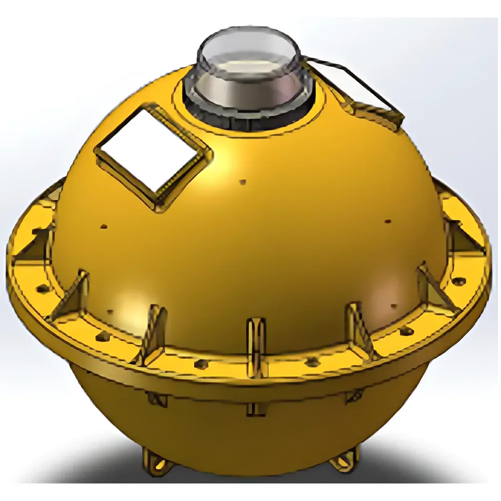
| Environmental Rating | IP68 submersion rating (up to 5 m), UV-stabilized polyethylene buoy hull |
| Dimensions | Ø300 mm × 420 mm (H), mass: 2.8 kg |
| Deployment Flexibility | Riverine, lacustrine, and coastal marine environments |
Overview
The Langcheng LS-DB300MM Surface Drifting Buoy is a compact, autonomous oceanographic tracking platform engineered for high-reliability deployment in dynamic surface water environments. It operates on the principle of Lagrangian drift tracking—measuring horizontal displacement of surface water masses via continuous dual-constellation GNSS positioning (GPS L1 + BeiDou B1I), enabling quantitative analysis of near-surface current velocity, direction, and dispersion patterns. Designed for long-term unattended operation, the buoy integrates a robust power management architecture, low-power embedded control unit, and satellite-based bidirectional telemetry via China’s BeiDou Navigation Satellite System (BDS). Its hydrodynamic profile and low-drag water sail system minimize wind-induced slip relative to true water motion—a critical design consideration for accurate Eulerian-to-Lagrangian flow vector reconciliation in coastal and shelf-sea studies.
Key Features
- GPS/BeiDou dual-mode GNSS receiver with <10 m horizontal position accuracy (CEP, 95%) under open-sky conditions; supports configurable fix intervals (1–300 min) and adaptive transmission scheduling.
- Integrated BeiDou short-message service (BDS-SMS) module enabling bi-directional command-and-control: remote firmware updates, sensor activation/deactivation, beacon toggling, and real-time parameter reconfiguration without physical access.
- Modular sensor interface compliant with RS-485 (Modbus RTU) and analog input standards (0–5 V, 4–20 mA), supporting seamless integration of third-party environmental probes—including conductivity-temperature-depth (CTD) modules, sea surface temperature (SST) thermistors, dissolved oxygen (DO) optodes, and turbidity sensors.
- UV-resistant high-density polyethylene (HDPE) buoy body with optimized drag coefficient (Cd ≈ 0.85) and submerged water sail geometry to reduce windage error (<15% at 10 m/s wind speed, per ITTC 1978 calibration protocols).
- Remotely controllable high-intensity LED navigation light (luminous intensity ≥ 2 cd, flash frequency 60 fpm), activated via BDS-SMS command for nighttime recovery operations in low-visibility maritime conditions.
- Intelligent power architecture featuring 12,000 mAh rechargeable Li-ion battery pack with thermal regulation, solar charging compatibility (optional), and dynamic duty cycling—extending operational endurance from 30 days (1-min sampling) to >240 days (60-min sampling + 6-hr transmission cycle).
Sample Compatibility & Compliance
The LS-DB300MM is certified for deployment across diverse aquatic regimes: inland rivers (Class I–III per China’s GB 3838-2002), freshwater lakes (including eutrophic systems), and coastal marine zones (≤50 km offshore, ≤20 m depth contour). Its IP68-rated electronics enclosure ensures reliable function during wave-induced immersion events (tested to 5 m static pressure for 2 h). The buoy complies with China’s mandatory electromagnetic compatibility standard GB/T 17626.2–2018 (ESD immunity) and GB/T 17626.3–2016 (radiated RF immunity). While not pre-certified for IEC 60945 or IMO A.694(17), its mechanical and electrical design aligns with marine environmental monitoring best practices referenced in ISO/IEC 17025-accredited field measurement protocols.
Software & Data Management
Data acquisition and telemetry are managed by Langcheng’s proprietary BuoyLink™ Embedded Firmware v3.2, supporting over-the-air (OTA) updates and secure AES-128 encrypted payload transmission. Raw GNSS logs, sensor readings, battery voltage, internal temperature, and diagnostic flags are packaged into standardized NMEA-0183-compliant frames and transmitted via BDS-SMS to Langcheng’s cloud-hosted OceanTrack Platform. This platform provides RESTful API access, time-series visualization, geospatial interpolation (IDW/Kriging), and automated QC flagging per IOOS QARTOD guidelines. Audit trails, user role permissions, and data export in NetCDF4/CSV formats support GLP-aligned workflows and integration with institutional data repositories (e.g., NOAA NDBC, EMODnet).
Applications
- Oceanographic process studies: quantification of surface eddy kinetic energy, river plume dispersion, and upwelling front tracking.
- Marine meteorology: validation of numerical weather prediction (NWP) model wind stress forcing and air–sea heat flux parameterizations.
- Environmental compliance monitoring: real-time verification of wastewater discharge dilution pathways and pollutant transport modeling in estuarine zones.
- Blue economy support: spatiotemporal mapping of optimal fishing grounds via co-deployed temperature-salinity anomaly detection; aquaculture site suitability assessment.
- Disaster response: rapid deployment for oil spill trajectory forecasting and search-and-rescue (SAR) drift modeling in typhoon-affected waters.
FAQ
What GNSS constellations does the LS-DB300MM support?
It natively supports GPS (L1 C/A) and BeiDou (B1I) signals with simultaneous multi-constellation tracking for improved positional availability in coastal canyons and urbanized shorelines.
Can the buoy be deployed in ice-covered waters?
No—it is rated for liquid-phase operation only; prolonged exposure to freezing temperatures or ice impact may compromise sensor integrity and hull structural stability.
Is the data transmission protocol compatible with international satellite networks (e.g., Iridium, Argos)?
The standard configuration uses BeiDou SMS only; Iridium SBD or Argos-compatible variants are available as OEM custom builds upon request.
Does the system meet FDA 21 CFR Part 11 or EU Annex 11 requirements for electronic records?
While not formally validated for regulated pharmaceutical or clinical use, the OceanTrack Platform includes audit trail logging, electronic signature support, and role-based access control—features aligned with ALCOA+ data integrity principles applicable to environmental monitoring under ISO 14001 and EPA Method 1600-series frameworks.
How is calibration traceability maintained for integrated sensors?
Third-party sensors must be supplied with NIST-traceable calibration certificates; Langcheng provides mounting fixtures and signal conditioning but does not perform sensor calibration—users retain full responsibility for metrological traceability per ISO/IEC 17025 clause 5.5.
Related Products


