Top Cloud-agri TP-GESB2.0 Automated Moth-Flushing & Intelligent Counting Pole
| Brand | Top Cloud-agri |
|---|---|
| Origin | Zhejiang, China |
| Manufacturer Type | Original Equipment Manufacturer (OEM) |
| Country of Origin | China |
| Model | TP-GESB2.0 |
| Pricing | Available Upon Request |
Overview
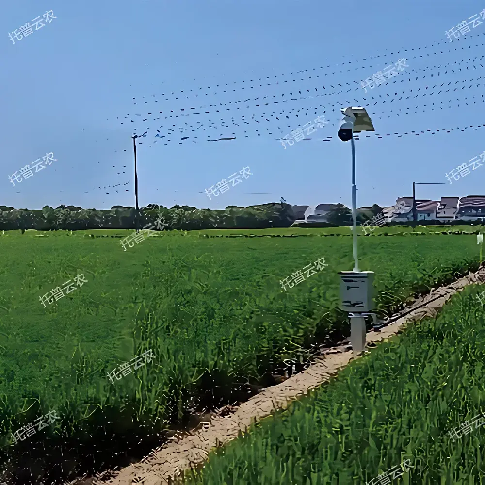
The Top Cloud-agri TP-GESB2.0 Automated Moth-Flushing & Intelligent Counting Pole is a field-deployable, edge-integrated monitoring system engineered for precision entomological surveillance in paddy ecosystems. It operates on a validated biological sampling principle: mechanical disturbance (controlled pole rotation and vertical oscillation) induces flight response in adult moths—primarily *Chilo suppressalis* (striped stem borer) and *Scirpophaga incertulas* (yellow stem borer)—followed by real-time video capture and AI-assisted object detection. Unlike passive trapping methods (e.g., light or pheromone traps), this system delivers quantitative, time-stamped, location-specific population density metrics—including total moth count per flush event, moths per hectare (converted from standardized 50 m² sampling area), and temporal density trends—enabling data-driven decision-making in integrated pest management (IPM) protocols.
Key Features
- Programmable autonomous operation: Scheduled daily flushing cycles with configurable start time, duration, and frequency; supports manual remote triggering via web-based control interface.
- Adaptive mechanical actuation: Motorized telescopic pole (max. extension: 4.0 m) with dual-axis articulation—vertical height adjustment (0.5–3.0 m range) and horizontal rotation (±120° sweep angle)—ensuring optimal alignment with rice canopy height across growth stages (tillering to heading).
- High-fidelity imaging subsystem: IP66-rated 4K-resolution CMOS camera with motorized zoom (5–30× optical), auto-focus, and dynamic exposure control; supports ROI (region-of-interest) cropping and frame-rate optimization (30 fps standard, adjustable to 60 fps for rapid flight tracking).
- On-device preprocessing & secure cloud upload: Embedded H.265 video compression reduces bandwidth usage; encrypted HTTPS transmission to TLS 1.3-compliant server infrastructure; metadata tagging includes GPS coordinates, timestamp (NTP-synchronized), environmental sensor readings (optional ambient temperature/humidity integration).
- Dual-mode deployment flexibility: Configurable for perimeter installation (e.g., bunds or levees) with segmented field mapping, or in-field placement enabling full 360° rotational coverage—both modes maintain consistent ground-level sampling geometry per IEC 60068-2-6 vibration compliance standards.
Sample Compatibility & Compliance
The TP-GESB2.0 is optimized for diurnal and crepuscular moth species exhibiting positive phototaxis and flight initiation upon mechanical perturbation. Validation studies confirm reliable detection of moths ≥8 mm wingspan under ambient illumination >50 lux. System design adheres to ISO 17025:2017 general requirements for competence of testing and calibration laboratories (applied to image-based counting validation workflows). Data output formats comply with FAO Pest Monitoring Data Exchange Standard v2.1 and support export to CSV, JSON, and XML schemas compatible with national agricultural surveillance platforms (e.g., China’s National Crop Pest Monitoring Network). All firmware and cloud services are designed to meet GLP-aligned audit trail requirements, including immutable logging of user actions, configuration changes, and algorithm versioning.
Software & Data Management
The proprietary Top Cloud-agri PestVision™ analytics suite provides browser-based access to processed video archives, annotated frames, and time-series visualizations. Each detected moth is tracked across consecutive frames using Kalman-filter-enhanced centroid association, eliminating double-counting artifacts. The system generates daily summary reports containing: total flush events, mean moths per flush, hectare-normalized density (moths/ha), 7-day rolling average, and deviation from historical baselines (user-defined reference period). Integrated pest forecasting modules apply empirically derived thermal accumulation models (degree-day thresholds per species) to recommend optimal intervention windows aligned with FAO-recommended action thresholds. All raw video, metadata, and analysis logs are retained for ≥18 months; role-based access control (RBAC) enforces data governance per ISO/IEC 27001 Annex A.8 policies.
Applications
- Regional pest surveillance networks requiring standardized, operator-independent field data collection across distributed paddy plots.
- Research institutions conducting longitudinal studies on moth phenology shifts under climate variability scenarios.
- Extension services supporting smallholder farmers with automated, interpretable pest pressure alerts linked to localized agronomic advisories.
- Regulatory agencies performing routine verification of pesticide resistance monitoring programs where precise baseline density quantification is mandated.
- Agri-tech integrators embedding TP-GESB2.0 outputs into broader digital farm management platforms via RESTful API (OAuth 2.0 secured).
FAQ
How does the system differentiate between moth species during video analysis?
Species-level classification is not performed autonomously; the system detects and counts flying Lepidoptera objects based on morphometric and kinematic features (size, wingbeat frequency, flight trajectory curvature). Species identification requires post-hoc expert validation using exported high-resolution video clips.
Is the device suitable for use in flooded paddy fields?
Yes—the pole base and control unit are rated IP67 for temporary submersion up to 1 m for 30 minutes; mounting hardware includes corrosion-resistant stainless-steel fasteners compliant with ASTM A276 Type 316 specifications.
Can the system operate without continuous internet connectivity?
Local edge storage (32 GB eMMC) retains up to 14 days of compressed video and metadata; synchronization resumes automatically upon network restoration without data loss.
What calibration procedures are required before deployment?
Initial geometric calibration (pole height/angle offset compensation) is performed once per installation site using built-in digital inclinometer and GNSS-derived ground elevation data; no periodic recalibration is needed under normal operating conditions.
Does the software support multi-language interfaces for international users?
English and Simplified Chinese UIs are natively supported; additional language packs (Spanish, Vietnamese, Thai) are available upon request and require ≥90-day lead time for linguistic validation.
Related Products