Top Cloud-agri TZS-ECW-G Soil Moisture, Temperature & Electrical Conductivity (EC) Analyzer
| Brand | Top Cloud-agri |
|---|---|
| Origin | Zhejiang, China |
| Manufacturer Type | Manufacturer |
| Country of Origin | Domestic (China) |
| Model | TZS-ECW-G |
| Instrument Type | Soil Moisture / Water Potential Analyzer |
| Power Supply | 7.4 V Li-ion battery (2.8 Ah) with charging protection |
| Internal Storage | 30,000 records in Flash memory |
| Expandable Storage | Standard 4 GB microSD card (user-replaceable) |
| Data Transmission | GPRS wireless upload (configurable interval or on-demand) |
| GPS | Integrated high-sensitivity module (records WGS84 coordinates with each measurement) |
| Sensor Interface | IP67-rated hub supporting up to 32 sensor channels |
| Operating Temperature Range | –40 °C to +100 °C |
| Soil Temperature Range | –40 °C to +100 °C |
| Temp. Accuracy | ±0.5 °C |
| Temp. Resolution | 0.1 °C |
| Soil EC Range | 0–20 mS/cm |
| EC Accuracy | ±2% FS |
| EC Resolution | 0.01 mS/cm |
| Soil Volumetric Water Content (VWC) Range | 0–100% (m³/m³) |
| VWC Accuracy | ≤±3% (relative error) |
| VWC Response Time | ≤2 s |
| VWC Resolution | 0.1% |
| Cable Length (standard) | 1.5 m (customizable up to 1000 m) |
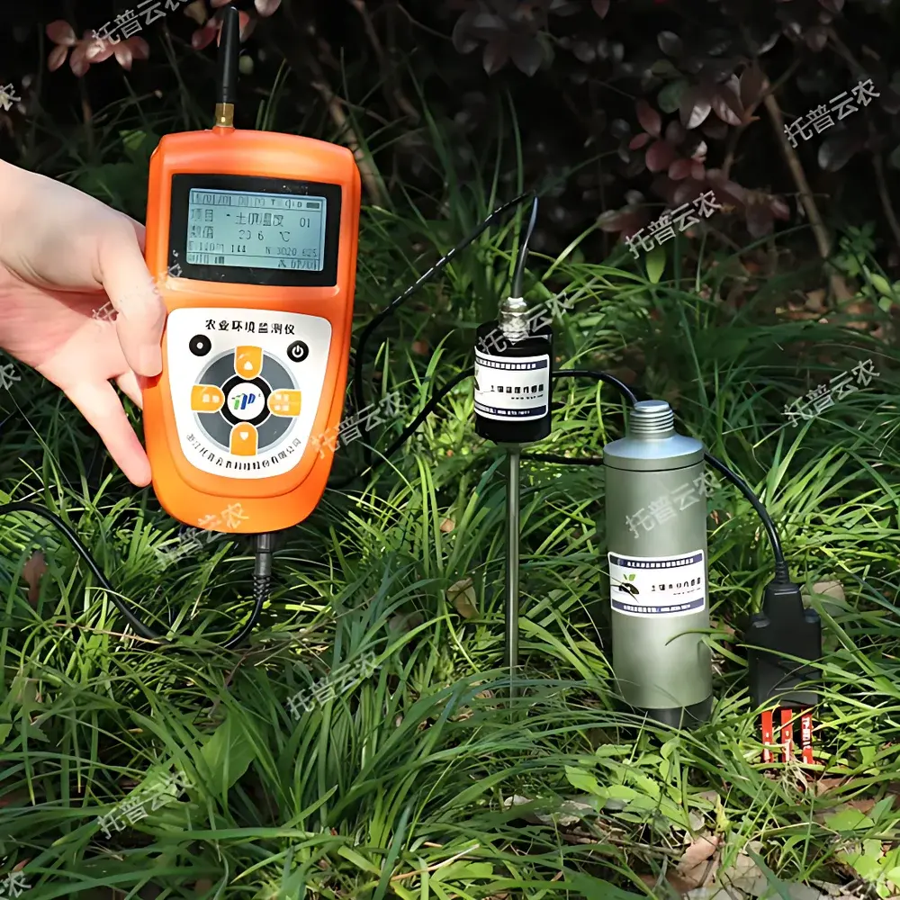
| Display | Backlit Chinese LCD showing real-time values, timestamp, GPS coordinates, storage status, and system diagnostics |
| Software Support | Cross-platform cloud platform (web + Android/iOS app), FDA 21 CFR Part 11–compatible audit trail optional, GLP/GMP-ready data export (CSV, PDF, Excel) |
Overview
The Top Cloud-agri TZS-ECW-G is a field-deployable, multi-parameter soil analyzer engineered for simultaneous, in situ quantification of volumetric water content (VWC), temperature, and electrical conductivity (EC)—a proxy for soluble salt concentration—in natural and managed soils. Based on calibrated frequency-domain reflectometry (FDR) for moisture, precision thermistor-based sensing for temperature, and solid-state galvanic EC electrodes embedded directly in the soil matrix, the instrument delivers rapid, non-destructive measurements without requiring soil extraction or lab processing. Its integrated architecture supports autonomous operation across diverse agro-environmental settings—from arid-zone irrigation scheduling to forest floor monitoring—where real-time, spatially referenced soil physical data inform decision-making under resource constraints.
Key Features
- Triple-parameter acquisition: Simultaneous measurement of VWC (% m³/m³), temperature (°C), and EC (mS/cm) in a single probe insertion.
- Integrated GNSS positioning: Built-in GPS module logs WGS84 coordinates with every recorded dataset, enabling georeferenced mapping and spatial interpolation.
- Dual-storage architecture: 30,000 measurements retained in internal Flash memory; expandable to indefinite capacity via standard 4 GB microSD card (hot-swappable).
- GPRS-enabled telemetry: Configurable transmission intervals (5 min to 99 h) or manual trigger uploads to secure cloud server; accessible globally via web browser or native mobile app (iOS/Android).
- Low-power embedded design: Average standby current 7 days on single battery charge (7.4 V / 2.8 Ah Li-ion with over-discharge protection).
- Modular sensor expansion: IP67-rated junction box accepts up to 32 heterogeneous sensors (e.g., pH, NPK, CO₂, rainfall) without cross-channel interference or recalibration.
- On-device intelligence: Real-time threshold-based voice alerts (Mandarin), configurable display interface, timestamped logging, and diagnostic self-checks.
Sample Compatibility & Compliance
The TZS-ECW-G is validated for use in mineral soils, loams, sandy substrates, and organic-rich media (e.g., peat, compost-amended fields). Its stainless-steel sensor rods and epoxy-sealed electronics meet IP67 ingress protection standards for prolonged burial in saturated or freeze-thaw conditions. Calibration traceability aligns with ISO 11277 (soil description), ASTM D5859 (in-field EC measurement), and FAO guidelines for soil moisture monitoring networks. Data integrity protocols—including time-stamped metadata, GPS geotags, and immutable record IDs—support compliance with GLP and GMP documentation requirements. Optional audit-trail configuration satisfies FDA 21 CFR Part 11 criteria for electronic records in regulated environmental reporting.
Software & Data Management
The proprietary Top Cloud-agri Instrument Cloud Platform operates on a hybrid C/S architecture, aggregating data from portable units, fixed stations, and third-party IoT devices into a unified relational database. Web and mobile interfaces support real-time dashboards, temporal trend visualization (line/bar charts), spatial heatmaps (via KML export), and automated report generation (PDF/CSV/Excel). All datasets retain full provenance: sensor ID, calibration epoch, operator tag, location coordinates, and firmware version. Platform-level encryption (TLS 1.2+), role-based access control, and scheduled backup ensure data sovereignty and continuity. Remote OTA firmware updates maintain long-term interoperability and regulatory alignment.
Applications
- Agricultural water management: Optimizing drip/sprinkler irrigation schedules using real-time root-zone moisture deficits and salinity thresholds.
- Drought early warning systems: Deploying networked units across watersheds to quantify soil water holding capacity loss and recharge dynamics.
- Ecological restoration monitoring: Tracking post-disturbance soil recovery metrics in reforestation or grassland rehabilitation projects.
- Environmental impact assessment: Quantifying leaching potential and salt accumulation beneath landfill caps or industrial effluent zones.
- Academic pedagogy & research: Supporting undergraduate soil physics labs and long-term edaphic studies requiring high-temporal-resolution field data.
- Urban green infrastructure evaluation: Measuring infiltration performance and moisture retention in bioswales, green roofs, and permeable pavements.
FAQ
What is the recommended calibration frequency for field-deployed units?
Calibration verification is advised before each seasonal campaign or after 6 months of continuous operation; factory calibration certificates are provided with each unit.
Can the device operate in frozen soil conditions?
Yes—the temperature sensor remains functional down to –40 °C, though VWC readings below 0 °C require interpretation per ISO 11274 frost-correction protocols.
Is the microSD card hot-swappable during active logging?
Yes—data capture continues uninterrupted when replacing the card; new files are auto-initialized with sequential naming and timestamped headers.
Does the cloud platform support API integration with GIS or SCADA systems?
Yes—RESTful JSON APIs are available under enterprise licensing, enabling bidirectional synchronization with ArcGIS Online, QGIS, or industrial automation platforms.
How is sensor drift compensated over extended deployments?
The firmware implements adaptive baseline correction using periodic zero-point checks against known reference media (e.g., dry sand, saturated NaCl solution), logged alongside raw sensor outputs.
Related Products


