Top Cloud-agri TPSQ-W-1 Soil Moisture & Environmental Real-time Monitoring System
| Brand | Top Cloud-agri |
|---|---|
| Origin | Zhejiang, China |
| Manufacturer Type | OEM/ODM Manufacturer |
| Country of Origin | China |
| Model | TPSQ-W-1 |
| Instrument Type | Soil Moisture & Water Potential Analyzer |
| Power Supply | Dual-mode (15W monocrystalline solar panel + 220V AC) |
| Battery Life | ≥15 days (standalone), indefinite with solar charging |
| Communication | 4G CAT1 (optional 5G), backward-compatible with 2G (China Unicom/China Mobile) |
| Enclosure Rating | IP65 (system), IP68 (soil sensors) |
| Data Storage | ≥400,000 records on microSD (5-year retention typical) |
| Positioning | Dual-band GNSS (GPS + BeiDou), altitude + coordinate logging, displacement detection algorithm |
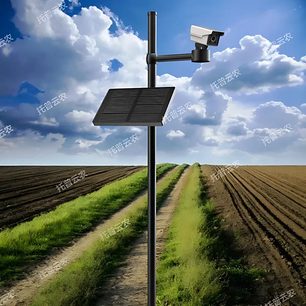
| Imaging | 2-MP CMOS sensor (1280×1080), 360° manual pan-tilt, scheduled remote capture |
| Operating System | FreeRTOS |
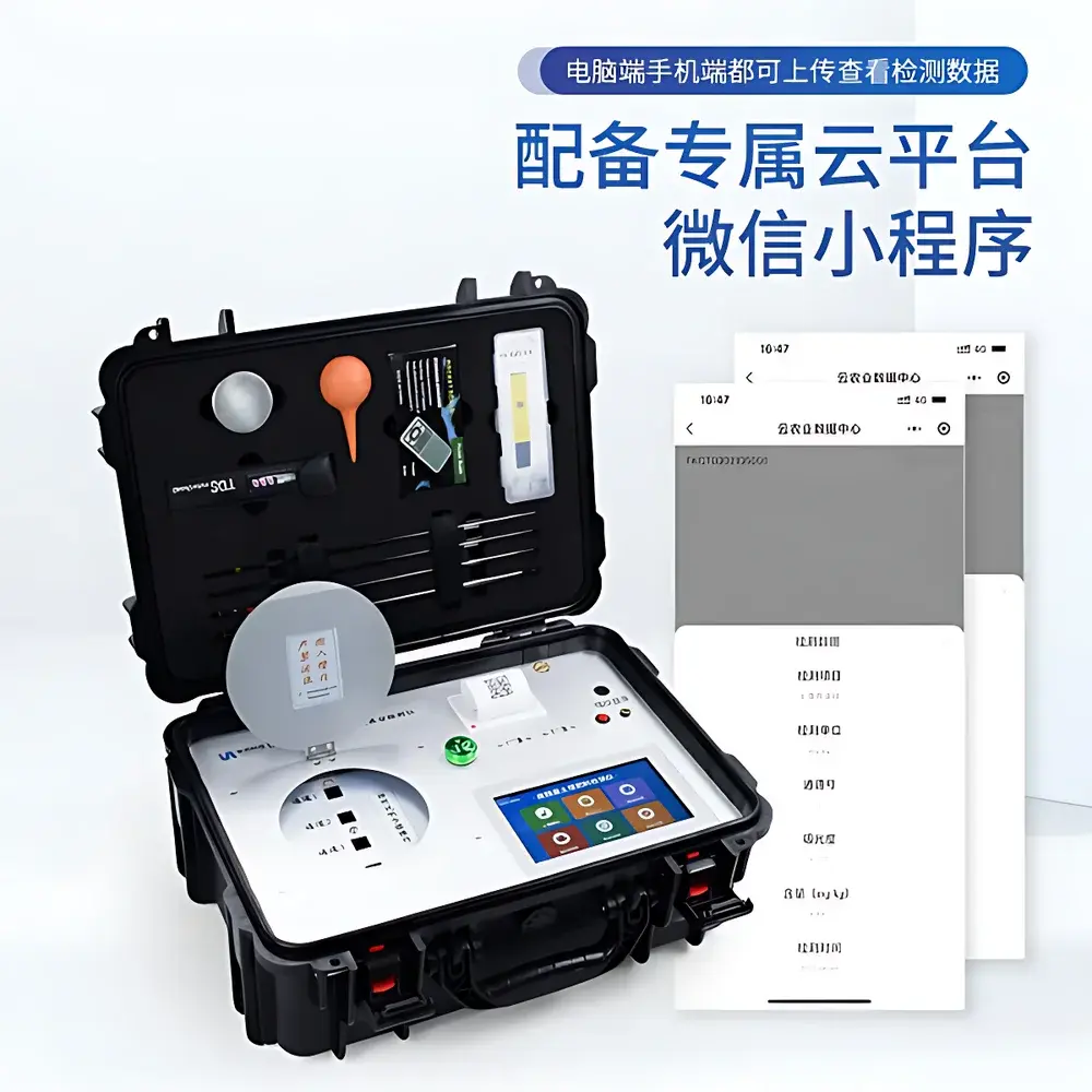
| Software Platform | B/S architecture cloud platform with Web + iOS/Android apps |
| Compliance | Designed for ISO 11277-compliant soil sampling context |
Overview
The Top Cloud-agri TPSQ-W-1 Soil Moisture & Environmental Real-time Monitoring System is an integrated field-deployable solution engineered for continuous, unattended measurement of critical agro-environmental parameters—including volumetric water content (VWC) across four discrete soil layers, soil temperature profiles, and time-series canopy imagery. It operates on the principle of frequency-domain reflectometry (FDR) for soil moisture quantification and precision thermistor-based sensing for thermal profiling—both validated against gravimetric and calibration-standard reference methods per ISO 11277 and ASTM D4959. The system is designed for long-term deployment in open-field, greenhouse, and orchard environments where real-time hydrological insight informs irrigation scheduling, drought stress assessment, and crop water productivity modeling. Its architecture integrates edge-level data acquisition, embedded processing, and secure cloud telemetry to support decision-making under variable climate conditions and resource-constrained farming systems.
Key Features
- Multi-layer soil monitoring: Simultaneous acquisition of VWC and temperature at four configurable depths (e.g., 10 cm, 20 cm, 40 cm, 60 cm), enabling vertical moisture flux analysis and root zone characterization.
- Dual-power resilience: 15W monocrystalline solar panel paired with a high-capacity lithium battery ensures >15 days of autonomous operation without solar input; seamless switchover between solar and 220V AC power sources.
- GNSS-enhanced geospatial fidelity: GPS + BeiDou dual-frequency positioning module delivers sub-5m horizontal accuracy, automatic coordinate and elevation registration, and algorithmic detection of unauthorized physical displacement—critical for asset security and spatial data integrity.
- Time-lapse phenological imaging: Integrated 2-megapixel CMOS camera (1/2.7″ sensor, 1280×1080 resolution) with manual 360° pan-tilt mechanism supports programmable image capture schedules; images are timestamped, geotagged, and uploaded to the cloud for dynamic playback of canopy development stages.
- Edge-to-cloud telemetry stack: 4G CAT1 cellular modem (5G optional) enables reliable data transmission under rural network coverage; protocol supports TLS 1.2 encryption, MQTT/HTTP(S) payloads, and firmware-over-the-air (OTA) updates via web or mobile interface.
- Robust mechanical design: IP65-rated enclosure for electronics housing; IP68-rated stainless-steel probe housings; 2-meter powder-coated stainless steel mast with two-section modular assembly for wind-load stability and corrosion resistance.
- Embedded real-time OS: FreeRTOS kernel ensures deterministic task scheduling for concurrent sensor polling, image compression, GNSS parsing, and communication handshaking—minimizing latency and jitter in time-critical measurements.
Sample Compatibility & Compliance
The TPSQ-W-1 is compatible with mineral soils, loams, sandy loams, and clayey textures within standard agricultural ranges (bulk density: 1.0–1.6 g/cm³; organic matter: <10%). Sensor probes are calibrated for soils with electrical conductivity ≤5 dS/m and pH 4–9. While not certified to IEC 61000-6-2/6-4 for industrial EMC, its EMI-hardened design meets FCC Part 15 Class B and CE RED requirements for outdoor environmental instrumentation. Data logging adheres to ALCOA+ principles (Attributable, Legible, Contemporaneous, Original, Accurate, Complete, Consistent, Enduring, Available) when deployed with user-defined audit trails and role-based access control on the cloud platform. The system supports configuration for USDA soil texture triangle classification and FAO-recommended field capacity/wilting point thresholds.
Software & Data Management
The proprietary Digital Agriculture Cloud Platform employs a browser-based (B/S) architecture accessible via HTTPS, with native iOS and Android applications. All sensor data—including raw timestamps, VWC/temperature arrays, GNSS coordinates, and image metadata—are ingested into a PostgreSQL-backed relational database with daily automated backups. Users configure customizable alert thresholds per parameter (e.g., VWC <35% at 20 cm depth triggers SMS/email notification). Analytical modules include: (1) ETo estimation using the FAO-56 Penman-Monteith equation with localized meteorological inputs; (2) relative water content (RWC) derivation from user-specified soil texture and bulk density; (3) root zone depletion modeling based on layer-specific moisture consumption rates; (4) 48-hour and 15-day precipitation forecasting fused with hyperlocal weather APIs. Export formats include CSV, PDF reports, PNG charts, and animated GIFs of phenological sequences—all compliant with internal lab SOPs and external review requirements.
Applications
- Irrigation optimization: Dynamic scheduling based on real-time root-zone moisture deficits and forecasted evapotranspiration.
- Drought early warning: Cross-referencing multi-depth VWC trends with satellite-derived NDVI and local rainfall accumulation.
- Crop phenology validation: Correlating canopy image-derived green area index (GAI) with soil water status during key growth stages (e.g., tillering, flowering, grain filling).
- Soil health monitoring: Long-term tracking of moisture hysteresis, temperature gradients, and infiltration patterns across seasonal cycles.
- Research-grade field trials: Supporting replicated plot studies requiring traceable, timestamped, location-stamped environmental covariates for statistical modeling (e.g., yield response functions, water use efficiency metrics).
- Extension service dashboards: Aggregating data from distributed TPSQ-W-1 nodes to generate regional soil moisture anomaly maps for advisory dissemination.
FAQ
What soil properties affect FDR-based moisture accuracy?
Electrical conductivity (EC), bulk density, and clay content influence dielectric permittivity interpretation; calibration curves are recommended for soils outside the 1–4 dS/m EC and 1.2–1.5 g/cm³ bulk density range.
Can the system operate without cellular coverage?
Yes—data is buffered locally on microSD card (≥400,000 records); transmission resumes automatically upon network restoration.
Is the cloud platform compliant with FDA 21 CFR Part 11?
While not formally validated for regulated pharmaceutical use, the platform implements electronic signature support, audit trails, and permissioned access—enabling adaptation to GLP/GMP-aligned agricultural research protocols.
How frequently can images be captured?
Configurable intervals from 15 minutes to 24 hours; up to 100 images per day stored locally before cloud upload.
Does the system support third-party API integration?
Yes—RESTful JSON APIs are available for integration with farm management software (e.g., Climate FieldView, Granular) and IoT middleware platforms (e.g., AWS IoT Core, Azure IoT Hub).