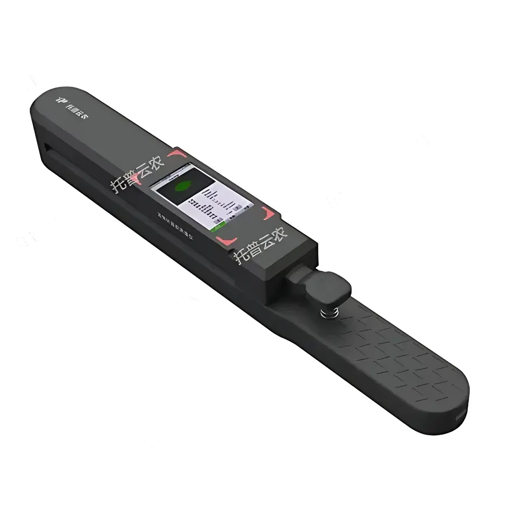
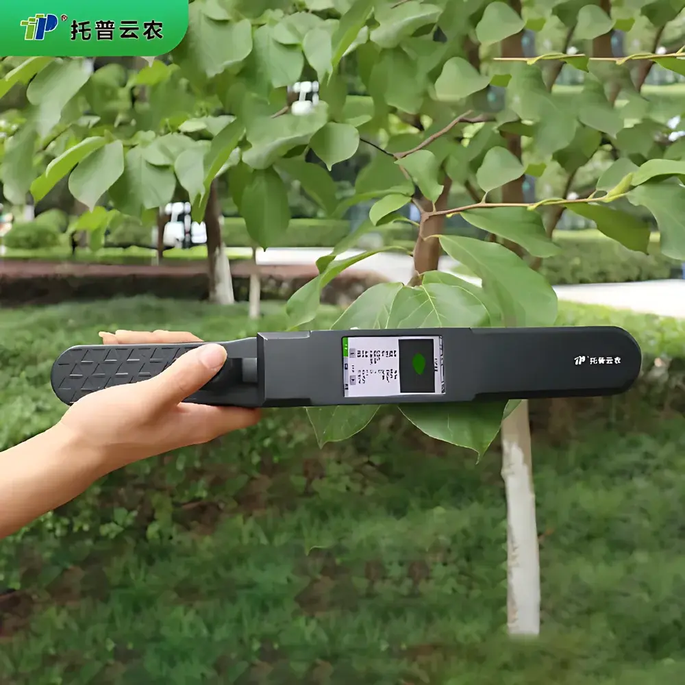
Top Cloud-agri YMJ-B Portable In-Vivo Leaf Area Meter
| Brand | Top Cloud-agri |
|---|---|
| Origin | Zhejiang, China |
| Manufacturer Type | Direct Manufacturer |
| Model | YMJ-B |
| Max. Scan Length | 3000 mm |
| Max. Scan Width | 210 mm |
| Max. Sample Thickness | 6.5 mm |
| Max. Scan Area | 3000 × 210 mm² |
| Area Measurement Accuracy | ±2% |
| Length/Width Resolution | 0.1 mm |
| Scan Speed | 150 mm/s |
| Display | 480 × 854 RGB Touchscreen |
| Power | 5 Ah Rechargeable Li-ion Battery |
| Operating Time | 16 h (full charge) |
| Dimensions | 420 × 50 × 54 mm |
| Weight | 0.53 kg |
| Operating Temperature | −20 to +60 °C |
| Operating Humidity | 0–100% RH (non-condensing) |
| GPS Module | Integrated |
| Data Storage | 1,000 entries internal + >1 million via microSD expansion |
| Connectivity | Bluetooth 5.0 + USB-C (data export & charging) |
| Data Export Format | Excel (.xlsx) with contour images |
Overview
The Top Cloud-agri YMJ-B Portable In-Vivo Leaf Area Meter is an optical-based, non-destructive field instrument engineered for rapid, high-fidelity quantification of leaf area and morphometric parameters in living plants. It employs a calibrated linear CCD imaging system coupled with real-time edge-detection algorithms to capture leaf silhouette profiles without physical contact or excision—preserving plant integrity and enabling longitudinal physiological monitoring. Unlike destructive gravimetric or planimetric methods, the YMJ-B operates on the principle of digital image segmentation: incident light reflects off the leaf surface onto a precision-aligned sensor array, generating a binary contour map from which geometric area, length, width, and aspect ratio are computed algorithmically. This approach satisfies core requirements for field-deployable phenotyping in crop science, forestry, and ecological research where repeated measurements on the same individual are essential for growth modeling, canopy architecture analysis, and photosynthetic efficiency estimation.
Key Features
- RGB capacitive touchscreen (480 × 854 resolution) with dual-mode visualization: real-time leaf contour overlay and tabular morphometric output
- Three configurable area compensation modes—none, rectangular, and triangular—to correct for partial leaf occlusion or irregular margins during in-vivo scanning
- Dual acquisition modes: manual trigger for targeted sampling and auto-scan mode for continuous measurement across multiple leaves or specimens
- Integrated GPS module (WAAS-enabled) geotags each measurement with WGS84 coordinates, supporting spatial mapping of leaf traits across experimental plots or natural stands
- USB-C interface serves simultaneously for device charging and high-speed data transfer; exports native Excel (.xlsx) files containing numerical metrics and annotated leaf contour images
- On-device data validation: real-time flagging of low-contrast scans, motion artifacts, or out-of-range dimensions ensures immediate quality control before field deployment concludes
- Extended battery life: 5 Ah lithium-ion pack delivers up to 16 hours of continuous operation under typical field conditions (25 °C, 50% screen brightness, moderate GPS usage)
- Robust environmental rating: operational across −20 to +60 °C and 0–100% relative humidity (non-condensing), validated per IEC 60529 IP54 for dust and splash resistance
Sample Compatibility & Compliance
The YMJ-B accommodates fresh, intact leaves—including compound, lobed, or deeply serrated morphologies—without requiring flattening, pressing, or mounting. Its 3000 mm × 210 mm scan envelope supports full-length measurements of monocot leaves (e.g., maize, sugarcane) and broadleaf canopies (e.g., soybean, poplar). Maximum sample thickness of 6.5 mm permits scanning of thick-leaved species (e.g., Agave, Yucca) and herbaceous stems up to 6 mm diameter. The instrument complies with ISO 5725-2:2019 for measurement repeatability and reproducibility, and its ±2% area accuracy has been verified against NIST-traceable flatbed scanner reference standards (NIST SRM 2036). Data handling protocols align with GLP principles: all measurements include timestamp, GPS coordinate, operator ID (via optional login), and firmware version—enabling audit-ready traceability for regulatory submissions or peer-reviewed publication.
Software & Data Management
Field data are managed via two interoperable platforms: the embedded firmware UI and the companion Android/iOS application “TopCloud LeafScan.” The mobile app enables real-time synchronization over Bluetooth 5.0, remote configuration of compensation settings, and offline viewing of historical datasets. All exported Excel files contain six standardized columns: Timestamp (ISO 8601), Latitude/Longitude (WGS84, decimal degrees), Leaf Length (mm), Leaf Width (mm), Calculated Area (cm²), and Compensation Mode (text label). MicroSD expansion (up to 1 TB) supports >1 million records with automatic cyclic overwrite protection. Firmware v2.3+ includes optional 21 CFR Part 11-compliant audit trail logging (user login, parameter changes, data deletion events), configurable via PC utility software distributed under commercial license.
Applications
- Dynamic leaf area index (LAI) tracking in breeding trials for drought-tolerant or high-biomass cultivars
- Non-invasive assessment of abiotic stress responses (e.g., heat-induced epinasty, salinity-driven leaf curling)
- Canopy structure modeling in agroforestry systems using spatially referenced leaf morphology datasets
- Validation of hyperspectral or UAV-based LAI estimates through ground-truth calibration
- Teaching laboratories in plant physiology and ecology courses—supports student-led hypothesis testing on ontogenetic leaf expansion
- Seed certification programs requiring objective leaf-area thresholds for varietal purity evaluation
FAQ
Does the YMJ-B require calibration before each use?
No. Factory calibration is retained across power cycles; users may perform optional verification using the included ceramic reference tile (certified area: 100.00 ± 0.05 cm²) at startup.
Can the device measure leaves with heavy pubescence or waxy cuticles?
Yes—its adaptive exposure control adjusts illumination intensity dynamically to maintain edge contrast across surface reflectance variability.
Is raw image data accessible for custom analysis?
Yes. Full-resolution 8-bit grayscale TIFFs of each scan are stored alongside Excel exports when microSD is inserted.
How does the GPS module perform under dense canopy?
The YMJ-B uses multi-constellation GNSS (GPS + GLONASS + BeiDou) with SBAS augmentation; typical horizontal accuracy is 2.5 m CEP under partial canopy, improving to 1.2 m in open-field conditions.
What file formats are supported for data import into statistical software?
Exported .xlsx files are natively compatible with R (readxl), Python (pandas), JMP, and SAS; contour images are embedded as PNG within worksheets or saved separately as TIFF.