Top Cloud-agri TPSQ-W-1 (TZS-GPRS-I Upgrade) Wireless Soil Moisture and Temperature Monitoring Station
| Brand | Top Cloud-agri |
|---|---|
| Origin | Zhejiang, China |
| Manufacturer | Yes |
| Country of Origin | China |
| Model | TPSQ-W-1 (TZS-GPRS-I Upgrade) |
| Instrument Type | Soil Moisture Monitoring Station |
| Power Supply | 15W Monocrystalline Solar Panel + Built-in Rechargeable Lithium Battery |
| Communication | Tri-band 4G (2G fallback), Optional 5G Module |
| Enclosure Rating | IP65 (Main Unit), IP68 (Soil Sensors) |
| Data Storage Capacity | 400,000 Records (≥5 Years at 15-min Interval) |
| Soil Depth Layers | 4 Stratified Probes |
| Measured Parameters | Volumetric Water Content (VWC), Soil Temperature, Field Imagery |
| VWC Range | 0–100% |
| VWC Resolution | 0.1% |
| VWC Accuracy | ±3% (0–50% VWC) |
| Soil Temp Range | −40°C to +85°C |
| Soil Temp Resolution | 0.1°C |
| Soil Temp Accuracy | ±0.5°C |
Overview
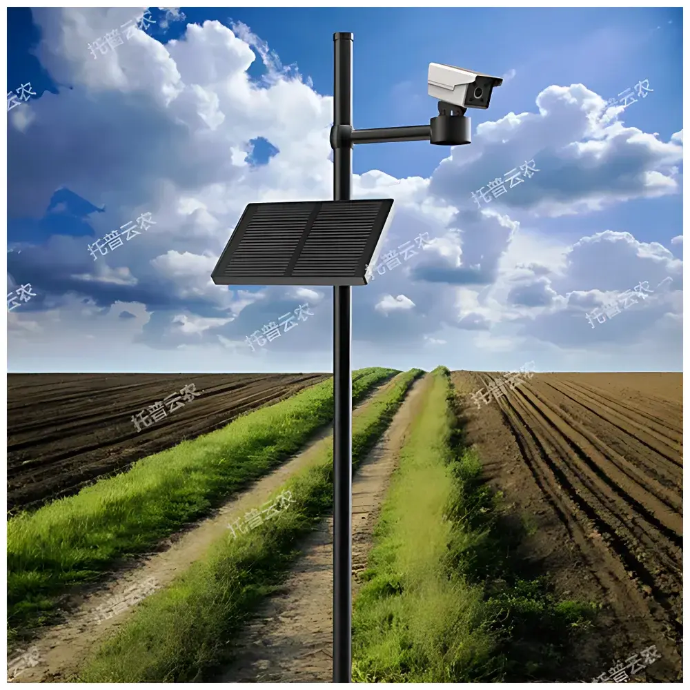
The Top Cloud-agri TPSQ-W-1 is an autonomous, solar-powered soil moisture and temperature monitoring station engineered for long-term, unattended deployment in agricultural, ecological, and hydrological research environments. It implements multi-depth capacitive sensing technology to quantify volumetric water content (VWC) and thermal profile across four vertically stratified soil layers—enabling high-resolution analysis of vertical moisture migration, infiltration dynamics, and root-zone water availability. The system operates on a dual-power architecture: a 15W monocrystalline solar panel provides primary energy input, while a high-capacity lithium battery ensures continuous operation for ≥15 days under zero-sunlight conditions. All sensor data—including time-stamped soil VWC, temperature, and georeferenced field imagery—are acquired via RS-485 interface, processed onboard, and transmitted wirelessly to the Top Cloud-agri Digital Agriculture Cloud Platform using tri-band 4G cellular connectivity (with optional 5G upgrade support and backward compatibility with 2G networks). This architecture supports ISO 11277-compliant soil moisture monitoring protocols and aligns with FAO’s guidelines for agronomic water balance modeling.
Key Features
- Multi-layer stratified sensing: Four independently calibrated soil probes installed at user-defined depths (e.g., 10 cm, 20 cm, 40 cm, 60 cm) deliver synchronized VWC and temperature profiles—critical for evaluating capillary rise, leaching risk, and effective root-zone depth.
- Integrated GNSS positioning & altitude acquisition: Embedded multi-constellation receiver (GPS, BeiDou, Galileo) delivers sub-5 m horizontal accuracy and automatic elevation metadata—essential for spatial interpolation, terrain-correlated modeling, and anti-theft geofencing.
- Onboard imaging capability: High-resolution camera captures scheduled or event-triggered field images, enabling phenological tracking, canopy cover estimation, and visual validation of sensor-derived moisture trends.
- Robust environmental resilience: IP65-rated main enclosure and IP68-rated probe housings ensure operational integrity under prolonged exposure to rain, dust, frost, and soil saturation—validated per IEC 60529 standards.
- Edge intelligence & remote maintenance: Firmware-over-the-air (FOTA) updates, remote diagnostics, and configurable sampling intervals (1 min to 24 h) minimize site visits and extend service life beyond 8 years in typical field deployments.
- Extended local storage: Non-volatile memory retains up to 400,000 timestamped records—supporting GLP-aligned audit trails and offline operation during transient network outages.
Sample Compatibility & Compliance
The TPSQ-W-1 is validated for use across diverse soil textures—from coarse sand to heavy clay—and performs reliably in saline soils (EC ≤ 4 dS/m) and organic-rich substrates (OM ≤ 25%). Sensor calibration adheres to ASTM D5720-20 (Standard Guide for Use of Capacitance-Based Soil Moisture Sensors) and supports traceable verification against gravimetric reference methods. System-level compliance includes CE marking (EMC Directive 2014/30/EU, RoHS 2011/65/EU), FCC Part 15 Subpart B (for 4G radio emissions), and adherence to China’s GB/T 33467–2016 standard for agricultural IoT monitoring devices. Data integrity mechanisms meet requirements for GxP-aligned environmental monitoring: full audit trail logging, immutable timestamps, and tamper-evident firmware signing.
Software & Data Management
The cloud platform provides role-based access control, RESTful API integration, and native support for MQTT and HTTP(S) data ingestion. All measurements are stored with ISO 8601 timestamps and WGS84 geocoordinates. Visualization tools include interactive time-series graphs, depth-profile heatmaps, and side-by-side comparative dashboards. Users may define crop-specific irrigation thresholds per FAO-56 guidelines, configure SMS/email alerts for threshold breaches, and generate PDF/CSV reports compliant with ISO/IEC 17025 documentation requirements. Predictive analytics modules apply machine learning (LSTM-based regression) to historical VWC, air temperature, precipitation, and evapotranspiration datasets—producing 7-day forward forecasts of relative soil water content (RSWC) and drought stress indices. Platform audit logs satisfy FDA 21 CFR Part 11 electronic record requirements, including electronic signatures, change history, and user activity tracking.
Applications
- Precision irrigation scheduling in orchards, vineyards, and row-crop systems
- Long-term watershed-scale soil water budget quantification
- Validation of land surface models (e.g., CLM, Noah-MP) used in climate forecasting
- Drought early-warning system deployment by regional meteorological bureaus
- Soil health monitoring in conservation agriculture and regenerative farming trials
- Calibration and ground-truthing of satellite-based soil moisture products (e.g., SMAP, Sentinel-1)
FAQ
What is the recommended installation depth configuration for the four soil sensors?
Standard deployment uses 10 cm, 20 cm, 40 cm, and 60 cm—but depths can be customized based on crop rooting depth and local pedology.
Does the system support integration with third-party SCADA or farm management software?
Yes—via documented REST API, Modbus TCP over cellular, or direct CSV export; compatible with FarmLogs, Granular, and AgLeader SMS platforms.
How frequently is firmware updated, and is version rollback supported?
Critical security patches are issued quarterly; minor feature releases occur biannually. Full version rollback and staged rollout controls are available in enterprise-tier subscriptions.
Can the camera operate in low-light or nighttime conditions?
The camera lacks active IR illumination and is optimized for daylight operation; image capture is disabled below 5 lux unless paired with external lighting.
Is calibration certificate traceable to national metrology institutes available?
Factory calibration certificates (ISO/IEC 17025-accredited) are provided upon request; on-site recalibration services are offered annually through authorized regional partners.
Related Products


