iMETOS iSCOUT Insect Monitoring and Early-Warning System
| Origin | Austria |
|---|---|
| Manufacturer Type | Authorized Distributor |
| Origin Category | Imported |
| Model | iSCOUT |
| Price Range | USD 1,400 – 7,000 |
| Camera Resolution | 10 MP |
| Memory | 1 GB |
| Imaging Frequency | Up to 3 times per day (configurable) |
| GPS Integration | Built-in |
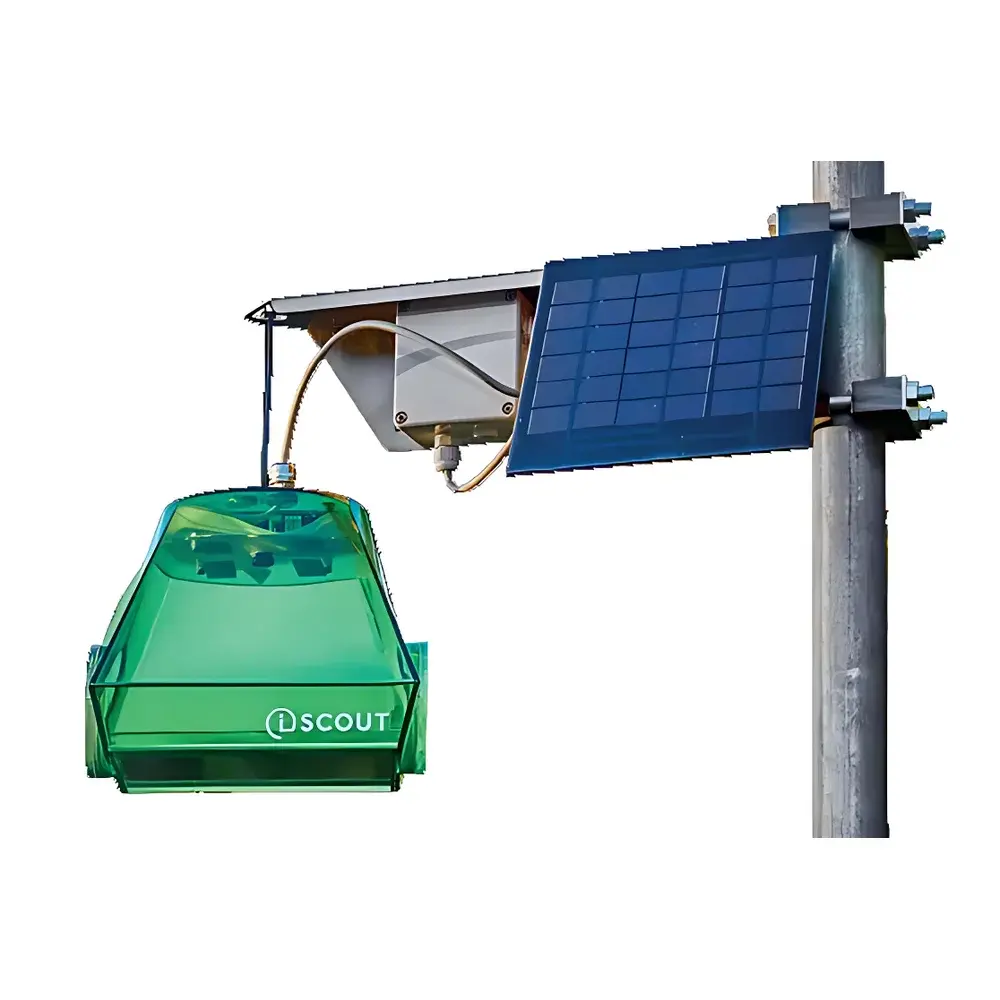
| Power Supply | Rechargeable Li-ion battery + 7.2 V / 333 mA solar panel (18 × 13 cm) |
| Dimensions | 20 × 15.5 × 17 cm |
| Weight | 930 g |
| Wireless Connectivity | Cellular (LTE-M/NB-IoT) or LoRaWAN |
| Data Platform | FieldClimate® cloud service |
| Coverage per Unit | 1–5 hectares |
| Trap Types | Pheromone-based, Drosophila-specific, General insect, Chromatic (blue/yellow/white) |
Overview
The iMETOS iSCOUT Insect Monitoring and Early-Warning System is an autonomous, field-deployable environmental sensor platform engineered for continuous, non-invasive surveillance of arthropod pest populations in agricultural, horticultural, and ecological research settings. Operating on the principle of digital image capture and automated pattern recognition, the system integrates high-resolution optical imaging with edge-based time-lapse acquisition and cloud-based machine vision analytics. Unlike manual scouting or passive trap counts, iSCOUT delivers temporally resolved, georeferenced entomological data—enabling longitudinal tracking of phenological emergence, population density shifts, and spatial dispersion patterns across managed or natural landscapes. Designed for unattended operation in remote outdoor environments, it supports regulatory-compliant pest monitoring workflows aligned with Integrated Pest Management (IPM) frameworks and EU Plant Health Regulation (EU) 2016/2031.
Key Features
- 10-megapixel CMOS imaging module with auto-focus and LED-assisted low-light capability for consistent capture of sticky-trap surfaces under variable ambient conditions
- Programmable imaging schedule: configurable to acquire 1–3 images daily; timestamped metadata embedded in each JPEG file (EXIF-compliant)
- Onboard 1 GB flash memory buffer ensures data persistence during transient network outages; automatic overwrite policy prevents storage saturation
- Integrated GPS receiver (±5 m CEP) provides precise unit localization; coordinates are synchronized with each image upload and visualized via interactive map layer in FieldClimate®
- Dual-power architecture: rechargeable lithium-ion battery (rated for ≥6 months standby life) supplemented by a 7.2 V / 333 mA monocrystalline solar panel (18 × 13 cm), optimized for European insolation profiles
- Modular trap compatibility: supports standardized adhesive boards mounted in weatherproof capture chambers, with four dedicated trap configurations—pheromone-baited, Drosophila-targeted, broad-spectrum, and chromatic (blue/yellow/white)—each validated against taxonomically defined target species groups
- Wireless telemetry via LTE-M, NB-IoT, or LoRaWAN protocols; firmware-upgradable over-the-air (OTA) for adaptive algorithm deployment and security patching
Sample Compatibility & Compliance
The iSCOUT system is validated for monitoring over 40 economically significant insect taxa, including Cydia pomonella (codling moth), Lobesia botrana (grapevine moth), Drosophila suzukii (spotted wing drosophila), Frankliniella occidentalis (western flower thrips), and Trialeurodes vaporariorum (greenhouse whitefly). Trap selection follows ISO 7816-1:2019 guidelines for adhesive surface geometry and adhesive viscosity. Image datasets generated by iSCOUT comply with FAO’s International Standards for Phytosanitary Measures (ISPM No. 8) for pest reporting and support traceability requirements under EU Regulation (EC) No 178/2002. The FieldClimate® platform maintains audit-ready logs—including user access records, image ingestion timestamps, and classification confidence scores—for GLP-aligned field trials.
Software & Data Management
Data acquisition, processing, and visualization occur through the FieldClimate® web and mobile application—a secure, ISO/IEC 27001-certified SaaS platform hosted in EU-based Tier III data centers. Uploaded images undergo server-side convolutional neural network (CNN) analysis trained on >2.1 million annotated entomological images. Classification outputs include species-level identification (where morphologically discriminable), count estimates per image, cumulative daily totals, and normalized seasonal abundance indices. Time-series charts support export in CSV/PNG formats; API endpoints enable integration with farm management software (e.g., AgriWebb, FarmLogs) and statistical analysis tools (R, Python pandas). All user actions and system events are logged with immutable timestamps in accordance with FDA 21 CFR Part 11 electronic record requirements.
Applications
- Real-time detection of first-flight thresholds for targeted pesticide application timing in orchards and vineyards
- Long-term phenological modeling of pest emergence in response to climate variables (e.g., growing degree days, precipitation anomalies)
- Spatial interpolation of trap density data to generate county-scale pest pressure maps for regional advisory services
- Validation of biocontrol agent efficacy through comparative trap catch reduction metrics across treatment blocks
- Supporting organic certification documentation by providing auditable, timestamped evidence of pest presence/absence at critical crop growth stages
- Ecological monitoring of non-target arthropod communities in conservation agriculture and agroforestry systems
FAQ
How does iSCOUT ensure accurate species identification from sticky-trap images?
Classification accuracy relies on a hybrid approach: deep learning models trained on region-specific specimen libraries are combined with rule-based filters (e.g., size, aspect ratio, color histogram thresholds) to reduce false positives. Confidence scores accompany every identification; low-confidence detections trigger manual review queues in FieldClimate®.
Can multiple iSCOUT units be synchronized to form a coordinated monitoring grid?
Yes—units are assigned unique MAC addresses and registered to a shared organizational account. Spatial correlation analysis across devices is enabled via geofencing tools and cross-unit temporal alignment using NTP-synchronized clocks.
Is offline operation supported if cellular connectivity is unavailable?
The device continues scheduled imaging and stores images locally. Once connectivity resumes, buffered data uploads automatically in chronological order without loss or duplication.
What maintenance is required for long-term field deployment?
Sticky boards require replacement every 7–14 days depending on pest pressure; solar panel surfaces should be wiped quarterly to maintain charge efficiency. No internal calibration or mechanical servicing is needed within the 5-year rated operational lifespan.
Does the system support custom species model training?
FieldClimate® offers enterprise-tier access to a model retraining portal where users may submit verified ground-truth image sets for supervised fine-tuning of CNN classifiers—subject to biological validation by iMETOS’ entomology team.


