GaiaSky-mini UAV-Mounted Hyperspectral Imaging System
| Origin | Sichuan, China |
|---|---|
| Manufacturer Type | Distributor |
| Origin Category | Domestic |
| Model | GaiaSky-mini |
| Price | ¥650,000 |
| Operating Principle | Push-broom |
| Imaging Method | Dispersive |
| Deployment Mode | Ground-based & UAV-mounted |
| Spectral Range | 400–1000 nm |
| Spectral Resolution | 3 nm |
| Spatial Resolution | Height-dependent |
| Total Field of View (TFOV) | 30° |
| Instantaneous Field of View (IFOV) | 700 × 700 µrad |
| Frame Rate | 53 fps |
Overview
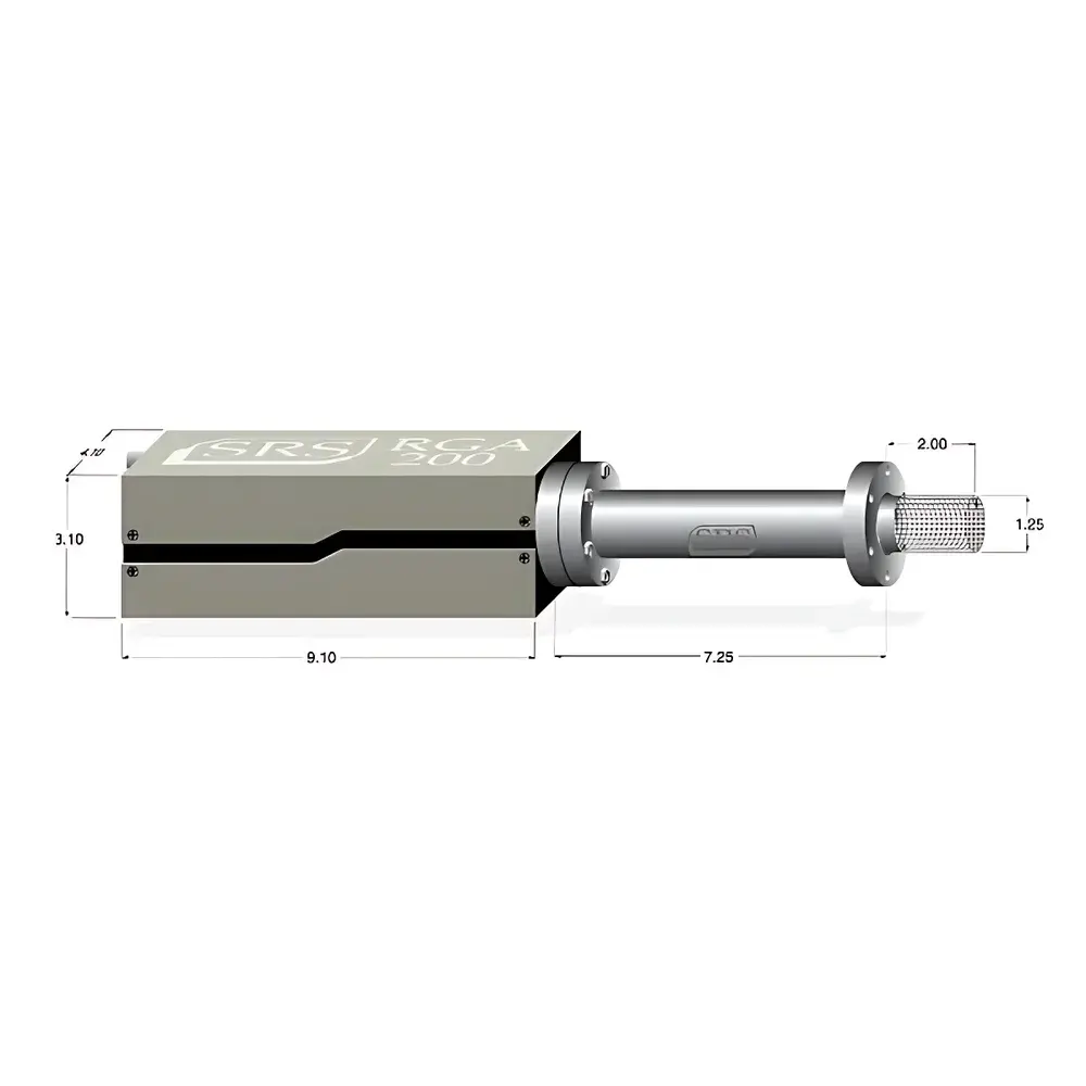
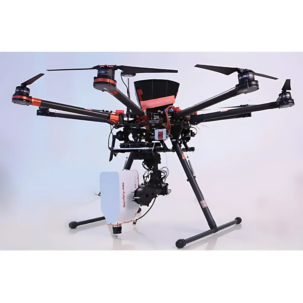
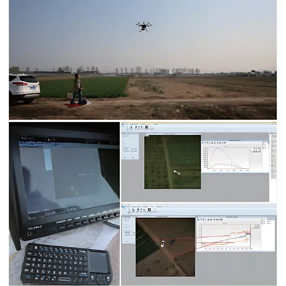
The GaiaSky-mini is a compact, UAV-optimized push-broom hyperspectral imaging system engineered for high-fidelity spectral data acquisition from low-altitude aerial platforms. It operates on the principle of spatial-spectral scanning: as the platform moves forward, an internal precision scanning mechanism synchronizes line-by-line image capture with real-time motion compensation—eliminating geometric distortion and radiometric degradation typically induced by micro-vibrations in lightweight rotary-wing UAVs. Its dispersive optical architecture employs a high-efficiency transmission grating and optimized F/2.8 fore-optics to deliver consistent throughput (>50% average across 400–1000 nm) while maintaining spectral fidelity. Designed for operational robustness in field-deployable environments, the system integrates inertial stabilization, automatic exposure control, and adaptive scan-speed matching—enabling reliable acquisition without reliance on high-grade INS or ground-control infrastructure.
Key Features
- Integrated active stabilization: Proprietary gimbal-coupled scanning compensates for UAV-induced jitter, ensuring sub-pixel registration stability during hover-based acquisition.
- Real-time adaptive exposure: Dynamically determines optimal integration time via pre-scan luminance analysis—maximizing SNR while preventing saturation; includes live overexposure warning overlay.
- Intelligent scan-speed synchronization: Automatically calculates line rate based on measured frame latency and exposure duration—preventing spatial stretching or compression artifacts in final hypercubes.
- Dual-camera workflow: Co-aligned auxiliary visible-light camera enables true WYSIWYG framing, real-time preview, and geo-referenced metadata tagging.
- Onboard radiometric preprocessing: Supports batch-mode radiance calibration, reflectance normalization (via reference panel), and region-of-interest correction—all executed prior to export.
- Cross-platform software compatibility: Native support for ENVI, ERDAS IMAGINE, and Evince formats (BIL/BIP/BSQ); includes SpecView acquisition suite with remote command interface and scriptable acquisition protocols.
Sample Compatibility & Compliance
The GaiaSky-mini is compatible with rotary-wing UAV platforms capable of stable hover flight—including DJI S1000-class octocopters and similar airframes with ≥330 mm vertical clearance and ≥200 × 260 mm payload bay dimensions. It operates within Class I safety limits per IEC 62471 for optical radiation exposure. Data acquisition workflows align with FAO’s Guidelines for Remote Sensing in Agriculture and EPA’s Protocol for Airborne Spectral Surveying (EPA/600/R-19/123). While not certified under FDA 21 CFR Part 11 or ISO/IEC 17025, its raw data structure (16-bit signed integer, IEEE 754-compliant metadata headers) supports traceable GLP/GMP-aligned processing pipelines when integrated with validated third-party analysis environments.
Software & Data Management
SpecView v3.x serves as the primary acquisition and preliminary processing engine. It runs natively on Windows 7/10 (32- and 64-bit) and provides full hardware abstraction for USB 2.0 communication with the Sony ICX285 CCD sensor (1392 × 1040 pixels, 6.45 µm pitch). Key capabilities include: automated dark-current subtraction, non-uniformity correction (NUC), spectral response normalization, and geotagging via optional Ellipse-N INS/GPS module. Export outputs adhere to standard ENVI header conventions (.hdr + .raw), preserving wavelength vectors, FWHM metadata, and radiometric scaling factors. All calibration files (radiance, reflectance, flat-field) are stored in human-readable XML format with versioned timestamps—facilitating audit trails in regulated research contexts.
Applications
- Agricultural phenotyping: Quantitative assessment of chlorophyll content, nitrogen status, water stress, and disease onset via narrowband indices (e.g., NDVI, PRI, MCARI) derived from contiguous spectral sampling.
- Environmental monitoring: Detection and mapping of algal blooms, suspended sediment loads, and submerged aquatic vegetation in inland and coastal waters using spectral unmixing algorithms.
- Military reconnaissance: Camouflage detection through material-specific spectral signature divergence in visible-near-infrared bands; supports spectral library matching against known target classes.
- Geological surveying: Discrimination of mineral assemblages (e.g., clays, carbonates, iron oxides) based on diagnostic absorption features between 400–1000 nm.
- Urban infrastructure inspection: Identification of roofing material degradation, thermal emissivity anomalies, and pavement composition shifts via hyperspectral texture-spectral fusion.
FAQ
What UAV platforms are officially validated for GaiaSky-mini integration?
The system has been tested and verified with DJI S1000 octocopters equipped with A2 flight controllers and BGC IG-500N inertial modules. Integration with other rotary-wing platforms requires mechanical mounting verification and electrical interface validation (5 V DC, USB 2.0, TTL trigger lines).
Is real-time georeferencing supported without external GNSS/INS?
Basic GPS-tagged metadata is available via optional 900 MHz telemetry link (GaiaSky-Datalink); however, centimeter-level geolocation accuracy requires integration with a certified INS/GNSS unit such as the Ellipse-N.
Can the system operate in continuous forward-flight mode?
Yes—though hover-based acquisition is recommended for highest radiometric consistency. Forward-flight operation necessitates precise velocity synchronization and may require post-acquisition orthorectification depending on terrain relief and flight altitude.
What is the effective spatial resolution at 300 m altitude using the 23 mm lens?
At 300 m AGL, the instantaneous field of view yields approximately 0.10 m GSD (ground sample distance) in cross-track direction; along-track resolution depends on scan line density and forward speed.
Does the system support radiometric calibration traceable to NIST standards?
Calibration is performed using factory-characterized quartz-halogen lamps and diffuse reflectance standards (Spectralon®). Full NIST-traceable recalibration services are available through authorized service centers upon request.
Related Products

")