TriOS AWRAMS Above-Water Radiance Auto-Measuring System
| Brand | TriOS |
|---|---|
| Origin | Germany |
| Model | AWRAMS |
| Sensor Type | Hyperspectral Radiometric System |
| Spectral Range | 280–950 nm |
| Detector | 256-channel silicon photodiode array |
| Spectral Sampling | 2.2–3.3 nm/pixel |
| Spectral Accuracy | ±0.2–0.3 nm |
| Field of View (LW) | 7° (air) |
| Cosine Response Accuracy | <10% deviation |
| IP Rating | IP67 |
| Operating Temperature | −10 °C to +50 °C |
| Power Supply | 24 VDC (18–30 V range) |
| Communication | RS-232 (TriOS protocol), 4G LTE |
| Data Storage | Onboard SD card + cloud upload |
| Positioning | GPS/BeiDou (±2 m accuracy, <0.5 s time sync) |
| Enclosure Material | 316L stainless steel |
| Weight | ~0.9 kg (stainless), ~0.7 kg (titanium) |
| Calibration Interval | 24 months |
Overview
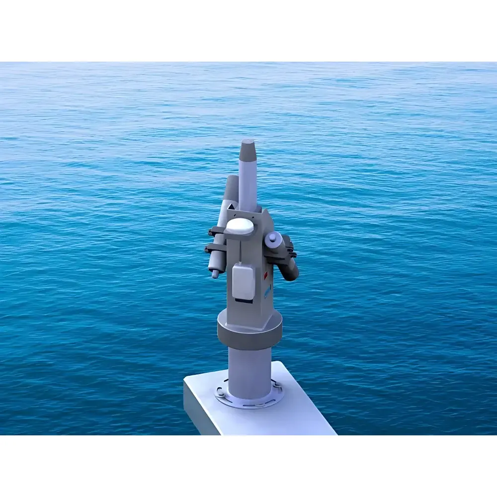
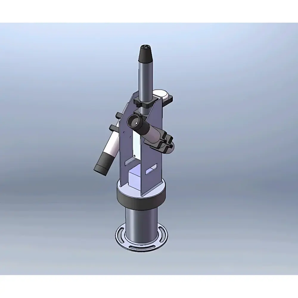
The TriOS AWRAMS (Above-Water Radiance Auto-Measuring System) is a field-deployable, automated hyperspectral radiometric platform engineered for rigorous above-water optical measurements in aquatic remote sensing applications. It implements the standard three-sensor configuration—comprising one downward-facing cosine-corrected irradiance sensor (RAMSES-ACC) and two radiance sensors (RAMSES-ARC)—to simultaneously acquire spectral downwelling solar irradiance (Es), water-leaving radiance (Lw), and sky radiance (Ls) at fixed or dynamically aligned viewing geometries. The system operates on the physical principles of radiative transfer in optically shallow and deep waters, enabling derivation of fundamental apparent optical properties (AOPs), including remote-sensing reflectance (Rrs) and normalized water-leaving radiance (nLw). Its design conforms to the CEOS/WGCV Ocean Color Radiometry (OCR) validation protocols and supports compliance with NASA’s Ocean Biology Processing Group (OBPG) and ESA’s Sentinel-3 OLCI calibration/validation requirements.
Key Features
- Automated azimuthal pan-tilt positioning synchronized with real-time solar geometry calculation using onboard GPS/BeiDou geolocation and precise time synchronization (±0.5 s)
- TriOS RAMSES hyperspectral sensor suite with factory-calibrated, traceable NIST-traceable spectral response across UV-VIS-NIR (280–950 nm), featuring 256-channel silicon photodiode arrays and spectral sampling resolutions from 2.2 to 3.3 nm/pixel
- Optimized dual-radiance geometry: upward-looking Lw sensor and downward-looking Ls sensor mounted at identical zenith angles relative to the water surface—critical for robust atmospheric correction and Rrs computation
- IP67-rated 316L stainless steel mechanical architecture with corrosion-resistant bearings and sealed electronics, validated for continuous operation in marine, lacustrine, and fluvial environments
- Low-power architecture (<0.85 W typical sensor draw) supporting extended autonomous deployment via 24 VDC input (18–30 V tolerance), compatible with solar-charged battery banks and wind-solar hybrid power systems
- Integrated wide-angle camera for contextual image capture of water surface and sky conditions—time-stamped and georeferenced for co-registration with spectral data
- Onboard SD card buffering with failover capability during intermittent 4G LTE connectivity; automatic encrypted upload to user-defined cloud servers via TLS 1.2
Sample Compatibility & Compliance
The AWRAMS system is designed for unattended, long-term deployment on fixed coastal towers, offshore buoys, riverbanks, lake piers, and ice platforms. Its spectral coverage (280–950 nm) supports measurement of key bio-optical constituents—including chlorophyll-a, phycocyanin (as a proxy for cyanobacteria), colored dissolved organic matter (CDOM), and total suspended matter (TSM)—across diverse water types: oligotrophic oceanic, eutrophic inland lakes, turbid estuaries, and polar sea-ice margins. All sensors meet ISO 17025-accredited calibration traceability standards, and the system architecture supports audit-ready data provenance required under GLP-compliant environmental monitoring programs. Firmware and software comply with IEC 62443-4-2 for secure embedded devices and enable full 21 CFR Part 11-compliant electronic records when deployed with TriOS’ optional audit trail module.
Software & Data Management
The TriOS OceanTools processing suite provides a GUI-driven workflow for batch ingestion of raw binary sensor files (.rad, .irr), automatic application of dark-current subtraction, nonlinearity correction, temperature compensation, and sensor-specific responsivity normalization. Outputs include standardized NetCDF-4/HDF5 files compliant with CF-1.8 conventions, containing georeferenced, time-tagged Es, Lw, Ls, Rrs, and nLw spectra with uncertainty propagation per band. The software includes built-in atmospheric correction modules (e.g., QAA, NIR-SWIR iterative methods) and supports export to SeaDAS, ENVI, and Python-based analysis pipelines (xarray, PySpectral). All processing steps are logged with immutable metadata, including GPS position, UTC timestamp, sensor ID, integration time, and calibration certificate expiry date—enabling full reproducibility and regulatory traceability.
Applications
- Ground-truthing and vicarious calibration of satellite ocean color sensors (e.g., Sentinel-3 OLCI, Landsat 9 OLI-2, PACE HARP2, NASA’s OCI)
- Time-series monitoring of phytoplankton bloom dynamics, harmful algal bloom (HAB) onset detection, and primary productivity estimation via photosynthetically active radiation (PAR) and spectral absorption modeling
- Development and validation of regional bio-optical algorithms for inland and coastal waters, particularly in optically complex environments affected by CDOM, mineral sediments, or ice-algal interactions
- Atmospheric correction algorithm intercomparison studies, especially under variable cloud cover, aerosol loading, and sun-glint conditions
- Long-term climate-relevant optical monitoring in polar regions, including snow-on-ice transmittance studies and under-ice phytoplankton bloom characterization
- Integration into national and international observing networks such as IOCCG, AERONET-OC, and GEO Blue Planet initiatives
FAQ
What spectral resolution and wavelength ranges does the AWRAMS support?
The system integrates TriOS RAMSES sensors covering UV (280–500 nm), VIS (320–950 nm), and extended VIS/NIR (320–950 nm) bands, with spectral sampling intervals of 2.2 nm/pixel (UV/VIS) and 3.3 nm/pixel (VIS/NIR), and spectral accuracy better than ±0.3 nm.
How is geometric alignment maintained between the upward and downward radiance sensors?
Both ARC sensors are manually pre-aligned to identical zenith angles (typically 40° ±10°) relative to the water surface plane during installation; mechanical rigidity and stainless-steel mounting ensure long-term angular stability without drift.
Can AWRAMS operate autonomously for extended periods without maintenance?
Yes—designed for unattended operation up to 12 months per service cycle, with 24-month calibration intervals, low-power consumption (48 h runtime during grid failure.
Does the system support real-time quality control of acquired spectra?
Yes—onboard firmware performs real-time signal-to-noise ratio (SNR) assessment, saturation flagging, and dark-signal consistency checks; flagged spectra are automatically excluded from cloud upload and marked in metadata.
Is the software compatible with third-party modeling environments like MATLAB or Python?
Yes—OceanTools exports NetCDF-4 files with CF-compliant metadata, and TriOS provides documented APIs and sample scripts for MATLAB, Python (netCDF4, xarray), and R integration.
Related Products