Auniontech HRU100-25 Intelligent Airborne Magnetic Detection System
| Brand | Auniontech |
|---|---|
| Origin | Shanghai, China |
| Manufacturer Type | Authorized Distributor |
| Product Category | Domestic |
| Model | HRU100-25 |
| Pricing | Upon Request |
Overview
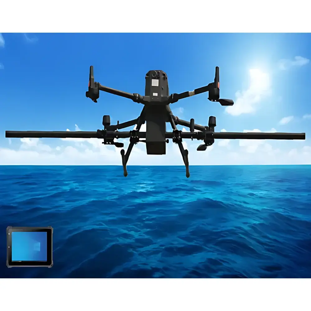
The Auniontech HRU100-25 Intelligent Airborne Magnetic Detection System is a high-sensitivity, real-time airborne magnetometer platform engineered for precise detection, localization, and identification of ferromagnetic objects in subterranean, underwater, and terrestrial environments. It integrates a rubidium vapor optically pumped magnetometer (OPM) with triaxial fluxgate vector sensors—enabling simultaneous measurement of total magnetic field intensity (scalar) and directional field components (vector). The system operates on the principle of quantum optical pumping, where circularly polarized laser light excites rubidium atoms in a vapor cell; magnetic field-induced Zeeman splitting modulates the atomic absorption spectrum, allowing sub-nanotesla resolution in total-field measurement. Coupled with real-time kinematic (RTK)-aided GNSS positioning and inertial navigation data, the HRU100-25 delivers georeferenced magnetic anomaly maps with centimeter-level spatial fidelity. Designed for deployment on multirotor UAVs, it supports rapid survey execution in complex topographies—including mountainous terrain, coastal shallows, and urban fringe zones—while maintaining robust performance under dynamic flight conditions.
Key Features
- Real-time dual-mode sensing: Simultaneous scalar (OPM) and vector (fluxgate) magnetic field acquisition at 10 Hz sampling rate
- Advanced onboard compensation architecture: Integrated attitude correction using inertial measurement unit (IMU) fusion, eliminating platform-induced magnetic interference via real-time quaternion-based coordinate transformation
- Extended operational range: Stable telemetry up to 5 km line-of-sight via encrypted RF link, supporting remote command, live anomaly coordinate streaming, and bidirectional status feedback
- Low-noise signal processing: Wavelet entropy denoising combined with envelope detection and adaptive bandpass filtering reduces system noise floor to ≤2 nT RMS (0.1–10 Hz bandwidth)
- Autonomous mission execution: Predefined grid or contour-based flight path planning with automatic takeoff, waypoint navigation, and landing—compatible with Pixhawk- and DJI-based autopilot ecosystems
- Modular hardware design: Tool-free quick-release mounting interface enables single-operator assembly and functional verification within ≤10 minutes
- Integrated display interface: Unified cockpit view showing real-time scalar/vector field magnitude, GNSS-derived position (WGS84), barometric altitude, IMU pitch/roll/yaw, and magnetic gradient vectors
Sample Compatibility & Compliance
The HRU100-25 is optimized for detecting ferromagnetic anomalies arising from buried ordnance (UXO), submerged wrecks, unmarked pipelines, geological ferrous structures, and anthropogenic infrastructure. Its sensitivity permits reliable detection of targets with magnetic moments ≥10 A·m² at standoff distances exceeding 4× the target’s characteristic linear dimension (e.g., ~8 m for a 2 m-long ordnance item), with post-compensation detection range enhancement of ~30% under typical survey conditions. The system complies with ISO 21648:2021 (Geophysical instrumentation — Airborne magnetic survey systems — Performance requirements and test methods) and meets electromagnetic compatibility (EMC) Class B limits per CISPR 32. All firmware and software modules are developed under traceable configuration management aligned with IEC 62304:2015 (Medical device software — Software life cycle processes), ensuring audit readiness for GLP/GMP-regulated environmental remediation and defense demining applications.
Software & Data Management
The system includes two core software suites: Hongyan Changfei (real-time acquisition) and Haitian Yise (post-processing). Hongyan Changfei runs on Windows 11 (22H2), requiring ≥8 GB RAM and Intel Core i5-8400 or equivalent; it provides live sensor synchronization, real-time mean-subtraction, dynamic windowing, serial data logging (timestamped ASCII format), and configurable compensation coefficient injection. Haitian Yise implements a multi-stage workflow: (1) dead-zone removal and outlier rejection; (2) Bayesian-informed long/short-term sequence anomaly detection; (3) OBF (Optimal Beamforming) and 2D residual CNN-based classification; (4) particle swarm optimization (PSO)-driven depth/position inversion; and (5) spatial interpolation (inverse distance weighting + kriging hybrid) for georeferenced magnetic imaging. All processing steps generate full audit trails compliant with FDA 21 CFR Part 11 requirements, including user authentication, electronic signatures, and immutable log files.
Applications
- Unexploded ordnance (UXO) detection and clearance in former conflict zones and military training ranges
- Underwater archaeological surveying—e.g., aircraft wreckage localization (as demonstrated in Dianchi Lake P-40 recovery mission, 6 m water depth, 18.5 m sediment burial)
- Infrastructure mapping: Buried steel pipelines, reinforced concrete structures, and abandoned utility corridors
- Geological prospecting: Mapping near-surface igneous intrusions, banded iron formations, and hydrothermal alteration zones
- Environmental site assessment: Identifying ferrous contamination plumes and landfill boundaries
- Border security and maritime domain awareness: Detection of submerged vessels or concealed metallic contraband
FAQ
What types of objects can the HRU100-25 detect?
It detects ferromagnetic materials with measurable magnetic dipole moments—including UXO, shipwrecks, vehicles, pipelines, and geological ferrous bodies—provided their magnetic signature exceeds the system’s 2 nT noise floor.
What is the achievable spatial resolution?
Ground sampling distance depends on flight altitude and sensor geometry; at 10 m AGL, lateral resolution is ≤0.5 m with interpolated anomaly centroids localized to <10 cm horizontal and <20 cm vertical error (RMS).
Can the system operate over water?
Yes—non-conductive media such as freshwater or seawater do not attenuate static or low-frequency magnetic fields; sensor operation remains unaffected, enabling consistent performance during marine surveys.
How is calibration performed?
Calibration combines in-flight figure-eight maneuvers (FOM) and stationary in-air rotation to estimate hard-iron, soft-iron, and scale-factor errors; coefficients are computed onboard and applied in real time.
Is the system compatible with third-party UAV platforms?
Yes—the payload interface follows MAVLink v2.0 standards with UART/USB-C connectivity; integration kits and API documentation are available upon request for custom airframe integration.


