AZ-R0810 Field-deployable Online Canopy Spectral Monitoring System
| Brand | AZ (Beijing Aozuo) |
|---|---|
| Origin | United Kingdom |
| Manufacturer | AZ Instrument Co., Ltd. |
| Product Type | Import |
| Model | AZ-R0810 |
| Principle | Effective Radiation Measurement Method |
Overview
The AZ-R0810 Field-deployable Online Canopy Spectral Monitoring System is an engineered solution for continuous, unattended spectral observation of vegetation canopies and leaf-level optical properties in natural field environments. Based on the effective radiation measurement principle—quantifying incident, reflected, and transmitted solar irradiance across ultraviolet (UV), visible (VIS), near-infrared (NIR), shortwave infrared (SWIR), and far-infrared (FIR) spectral domains—the system enables high-temporal-resolution characterization of biophysical and biochemical canopy dynamics. Unlike portable or snapshot spectroradiometers, the AZ-R0810 operates autonomously under all weather conditions, delivering time-synchronized spectral data at user-defined intervals—from 10 ms to hourly—without manual intervention. Its architecture supports multi-scale ecological inference: from leaf pigment concentration and water content estimation to landscape-level phenological mapping and satellite validation. Designed specifically for plant physiology, agroecology, and environmental remote sensing research, the system complies with foundational radiometric traceability practices aligned with ISO 17025–accredited calibration frameworks and supports integration into GLP-compliant long-term monitoring programs.
Key Features
- Full-spectrum coverage: UV (280–400 nm), VIS (400–700 nm), NIR (700–1300 nm), SWIR (1300–2500 nm), and FIR (up to 14,000 nm), including total hemispherical irradiance, photosynthetically active radiation (PAR), UV index, and directional reflectance/transmittance.
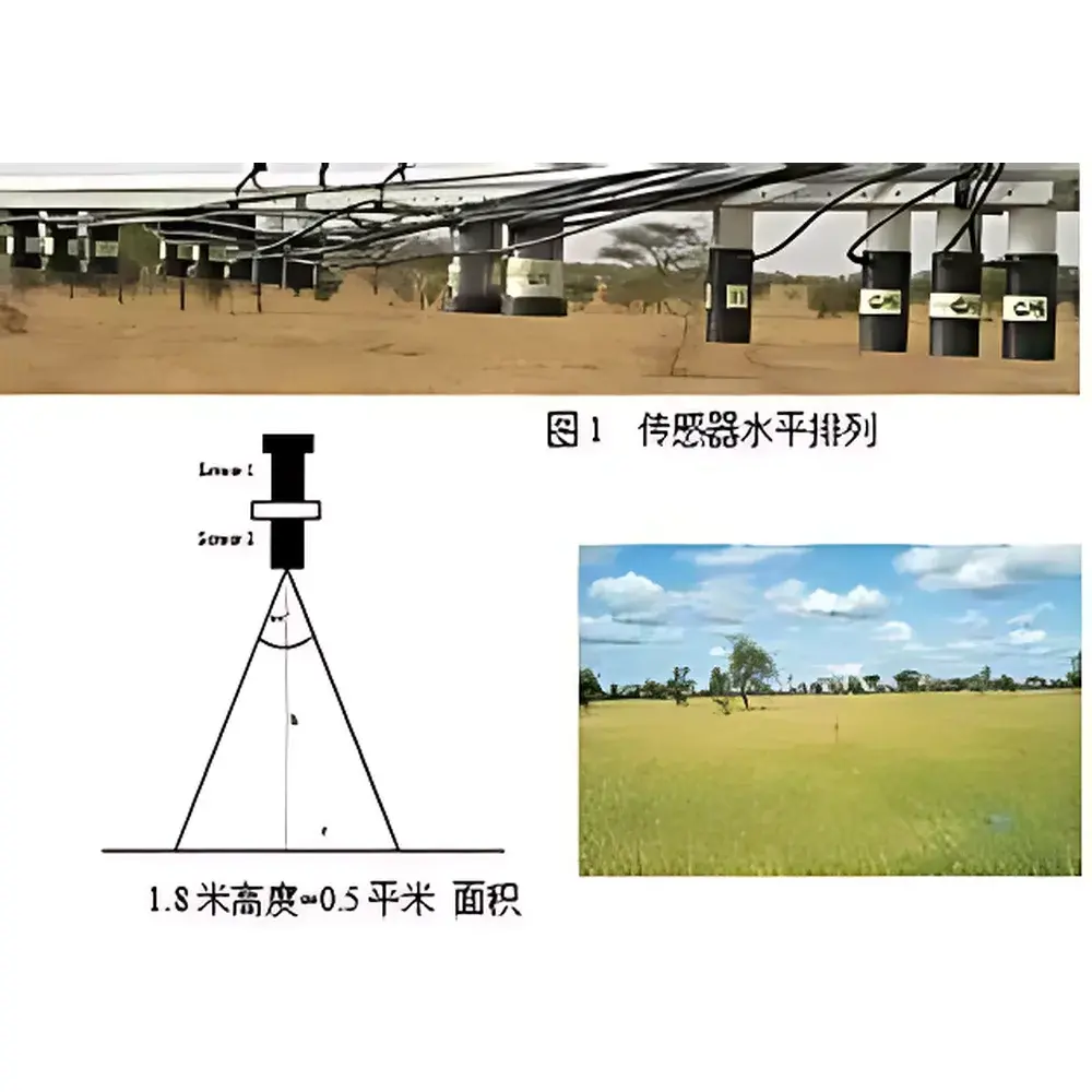
- Modular sensor configuration: Supports horizontal or arc-mounted deployment over heterogeneous canopies; field-of-view geometry optimized for 0.5 m² sampling area at 1.8 m height, with calibrated angular response per IEC 60904-9 standards.
- High-resolution temporal acquisition: Programmable sampling frequency from 10 ms to 60 min; synchronized multi-channel analog, pulse, and digital input logging (5–15 analog + 12 pulse + 12 digital channels).
- Robust field operation: IP67-rated enclosures, wide operating temperature range (−30 °C to +60 °C), integrated GPRS module for real-time data telemetry to ENVIdata cloud server.
- Onboard storage and redundancy: USB-based local data logging with automatic failover to remote transmission; timestamped metadata embedding (GPS, ambient T/RH, barometric pressure if optional sensors installed).
Sample Compatibility & Compliance
The AZ-R0810 is validated for non-destructive, in situ spectral monitoring of herbaceous and woody vegetation—including monocots (e.g., rice, maize, wheat) and dicots (e.g., tobacco, ginseng, pasture grasses)—under variable canopy architectures, LAI ranges (0.5–8.0), and stress conditions (drought, nutrient deficiency, heavy metal exposure). Sensor spectral responsivity is traceable to NIST-certified reference lamps and calibrated annually per ISO/IEC 17025 requirements. Data output conforms to CF Standard (Climate and Forecast Metadata Conventions) and NetCDF-4 format, ensuring interoperability with NASA’s LP DAAC, ESA’s Copernicus Ground Segment, and national agricultural monitoring platforms. The system meets electromagnetic compatibility (EMC) directives (EN 61326-1) and environmental protection standards (RoHS, WEEE) for deployment in protected ecological zones.
Software & Data Management
Data acquisition and processing are managed through two integrated software components: the embedded firmware of the AZ-R0810 data logger and the desktop/cloud-based Ecograph analysis suite. Ecograph computes standardized vegetation indices—including NDVI, RVI, EVI, SAVI, and Green Band Sum Index—with built-in atmospheric correction modules compliant with MODTRAN-based radiative transfer modeling. All index calculations adhere to ASTM E2922-21 (Standard Practice for Spectral Reflectance Measurements of Vegetation Canopies) and support batch processing of time-series datasets. ENVIdata serves as the secure, role-based cloud repository, offering audit-trail functionality per FDA 21 CFR Part 11 requirements, automated email alerts, RESTful API access, and TLS 1.3 encrypted data ingestion. Raw spectral files include full calibration coefficients, dark current subtraction, and cosine-corrected irradiance values.
Applications
- Phenological monitoring: Deriving start/end of season metrics via broadband greenness indices for climate impact assessment and land-use classification.
- Crop physiological diagnostics: Correlating spectral signatures (e.g., red-edge position, NIR plateau amplitude) with chlorophyll a/b ratio, nitrogen status, lignin/cellulose content, and grain protein yield.
- Stress detection: Quantifying anthocyanin accumulation (UV-B absorption), stomatal conductance proxies (thermal NIR slope), and canopy water content (970 nm and 1200 nm absorption features).
- Satellite validation: Providing ground-truth spectral time series for Sentinel-2, Landsat 9, and PlanetScope L1C/L2A product calibration and uncertainty quantification.
- Controlled-environment research: Integrating PAR and spectral irradiance feedback loops in growth chambers and vertical farms (as deployed at IGER, UK).
FAQ
What spectral resolution does the AZ-R0810 provide?
The system uses discrete-band filtered photodiodes—not scanning monochromators—therefore delivers broadband channel-integrated irradiance values rather than high-resolution spectra. Each channel corresponds to standardized wavebands defined by ISO 21348 and ASTM E2922-21.
Can the system operate without cellular connectivity?
Yes. Local data logging to USB flash memory continues uninterrupted during GPRS outages; synchronization resumes automatically upon network restoration.
Is calibration traceable to international standards?
All optical sensors are factory-calibrated against NIST-traceable tungsten-halogen and deuterium lamp sources, with certificate of calibration issued per ISO/IEC 17025.
Does Ecograph support custom index development?
Yes. Users may define new band ratios, normalized difference formulas, or regression models using raw channel outputs and export results in CSV, GeoTIFF, or NetCDF formats.
How is cosine error minimized for hemispherical irradiance measurements?
Each irradiance sensor incorporates a precision-ground diffuser meeting ISO 9060:2018 Class C cosine response specifications (<5% deviation up to 80° zenith angle).


