Arboradix AZ Pulse-Tree Tomography System
| Brand | AZ (Beijing AoZuo) |
|---|---|
| Origin | Germany |
| Manufacturer | Yes |
| Import Status | Imported |
| Model | AZ Pulse-Tree |
| Pricing | Upon Request |
| Power Supply | 12 V Rechargeable Battery |
| Software Options | 2D (Basic / Precision / Professional Editions), 3D Module |
| Communication | Bluetooth |
| Dimensions | 2D and 3D Configurable |
| Sensor Count | 2–24+ (scalable per application) |
| Spatial Resolution | Environment- and material-dependent |
| typical output resolutions | 2, 10, or 40 pixels (radial cross-section) |
| Data Output | Color-coded tomographic images (green = healthy wood, red = decay/cavities/fissures) |
| Compliance | Designed for field-deployable, non-invasive arboricultural assessment in accordance with ISO 17225-5 (wood quality evaluation), ASTM D6301 (acoustic methods for timber inspection), and EU Forest Health Monitoring Guidelines |
Overview
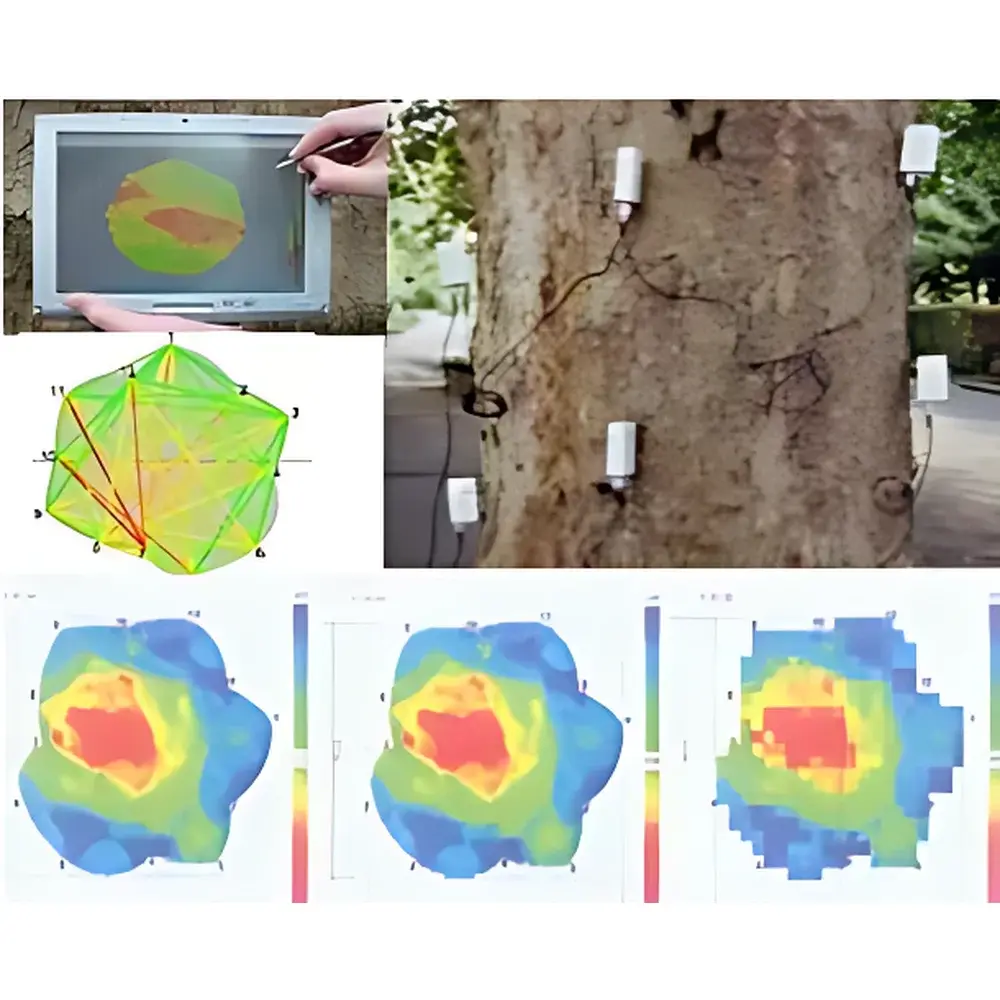
The Arboradix AZ Pulse-Tree Tomography System is a portable, non-destructive acoustic tomography instrument engineered for quantitative structural assessment of standing trees, felled logs, and urban forest assets. It operates on the principle of stress wave propagation time-of-flight (TOF) analysis: mechanical impulses generated by a calibrated impact hammer travel through woody tissue at velocities inversely correlated with local density, moisture content, and structural integrity. Sensors placed circumferentially around the trunk or log detect arrival times of these transient elastic waves. Using inverse reconstruction algorithms—based on generalized Radon transform principles—the system computes spatially resolved attenuation and velocity maps across radial sections. These are rendered as color-coded tomograms where green denotes regions of high acoustic velocity (intact xylem), yellow indicates transitional zones (early decay or moisture gradients), and red highlights low-velocity anomalies (cavities, rot, or fractures). Unlike conventional resistograph or drill-resistance methods, this technique requires no physical penetration, preserving tree viability and enabling repeated longitudinal monitoring.
Key Features
- Field-deployable modular architecture: scalable sensor arrays (2–24+ piezoelectric transducers) accommodate stem diameters from 200 cm without geometric constraint.
- Dual-mode acquisition: selectable 2D cross-sectional imaging (single-height ring) or 3D volumetric reconstruction via multi-level sensor deployment at defined vertical intervals (e.g., 0.5 m, 1.0 m, 1.5 m).
- Integrated hardware-software workflow: includes ruggedized handheld controller (Windows-based touchscreen tablet), Bluetooth-synchronized data acquisition, and real-time waveform visualization.
- Arboradix RootScan module optional: extends diagnostic capability to root plates using ground-coupled sensors and directional pulse excitation protocols.
- Battery-powered operation (12 V rechargeable Li-ion): supports ≥8 hours continuous field use with hot-swappable units.
- Calibration traceability: factory-certified sensor timing offsets and hammer energy consistency verified per ISO/IEC 17025-accredited procedures.
Sample Compatibility & Compliance
The system is validated for broadleaf and coniferous species including but not limited to Fagus sylvatica, Quercus robur, Picea abies, and Pinus sylvestris. Performance remains robust under ambient temperature ranges of −5 °C to +45 °C and relative humidity up to 95% (non-condensing). All firmware and software modules comply with EU Machinery Directive 2006/42/EC and EMC Directive 2014/30/EU. Data export formats (CSV, TIFF, PNG) support integration into GIS platforms and municipal tree inventory databases. Audit trails, user authentication, and electronic signature functionality align with GLP-compliant documentation requirements for municipal arboriculture departments and certified tree risk assessors (CTRA).
Software & Data Management
The proprietary Arboradix Suite provides tiered analytical capabilities: Basic Edition delivers real-time 2D tomogram generation and pass/fail thresholding; Precision Edition adds pixel-wise velocity calibration against reference wood samples and moisture correction algorithms; Professional Edition enables comparative longitudinal analysis across multiple measurement dates, automated cavity volume quantification, and report generation compliant with DIN EN 1995-1-1 (Eurocode 5) annexes for timber structural evaluation. All editions enforce FDA 21 CFR Part 11–compliant audit logging—including operator ID, timestamp, GPS metadata, sensor configuration, and raw waveform archives—with encrypted local storage and optional cloud backup via TLS 1.3–secured endpoints.
Applications
- Urban forestry risk assessment: identification of internal decay preceding external symptom manifestation in heritage or street trees.
- Timber quality grading: pre-harvest evaluation of log integrity prior to milling or veneer production.
- Ecological research: longitudinal monitoring of decay dynamics in old-growth forests or post-disturbance recovery studies.
- Root system diagnostics: detection of root collar rot, girdling roots, or mechanical damage using the Arboradix RootScan add-on.
- Insurance and legal forensics: objective, defensible documentation of structural compromise following storm events or construction-related root zone disturbance.
FAQ
What is the minimum and maximum trunk diameter supported?
No inherent lower or upper limit exists—the system adapts to any diameter via sensor spacing optimization and algorithmic interpolation. Practical field use spans 8 cm (young saplings) to 250 cm (ancient oaks).
Can measurements be performed in rainy conditions?
Yes—sensors feature IP67-rated housings; however, surface water film may attenuate signal coupling. Wiping bark surfaces before sensor placement is recommended.
Is training provided for certified arborists?
Yes—AZ offers ISO 17225-aligned operator certification courses accredited by the European Arboricultural Council (EAC), including hands-on field validation and report interpretation modules.
How is spatial resolution determined in practice?
Resolution depends on sensor count, angular distribution, and reconstruction grid density—not fixed pixel size. A 24-sensor array at 1.3 m height yields ~15° angular sampling, translating to effective radial resolution of ~2–5 mm in sound hardwoods under optimal coupling conditions.
Does the system meet requirements for municipal tree management compliance reporting?
Yes—output reports include metadata fields required by ISO 14001 environmental management systems and UK’s BS 5837:2012 Tree Surveys for Development, including georeferenced tomograms, measurement uncertainty estimates, and assessor credentials.